Home
Weather Dublin
WeatherRadar
RainfallRadar
TemperatureRadar
WindRadar
LightningRadar
Weather News
Editor's Pick
Discover the app
Weather widget
Contact us
Apps
    Home /

    Chilly but mostly settled days ahead

10:05
16 October 2026

Weekend weather
Chilly but mostly settled days ahead

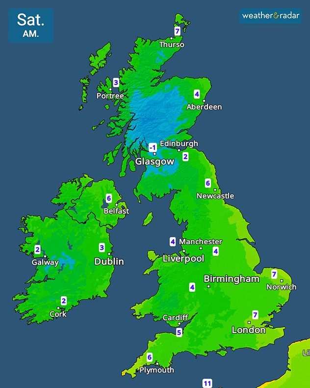
Saturday morning temperature map showing -1°C near Glasgow, 2 to 3°C across Ireland, and 4 to 7°C across much of England and Scotland.
A chilly start to Saturday morning may see patchy frost to the north.

The weekend is looking dry and settled for most of the UK and Ireland, though bringing a colder feel to the days.

After a warmer end to the week, more typical temperatures for this time of the year are set to return. Maybe requiring the winter coat in the mornings for the first time with lows around 4°C across central England and lower in parts of Ireland and Scotland where the Highlands wake to freezing conditions.

The cold evenings may lead to patchy frost in central to northern areas. Otherwise, the days are calm and settled, with only light winds. Just the North Sea coasts to the east and south-east are likely to see showers.

Sunday continues the largely dry theme for much of both countries. Through the day, showers may move further in-land from the east while cloud cover also builds to the far north, perhaps bringing patchy rain.

This is likely to change in the new week as high pressure fades, opening the door to lows and Atlantic systems to sweep back in. Initially this in the form of widespread rain risk across England and Wales.

Keep an eye on those showers with the WeatherRadar as you head out into the autumnal conditions this weekend!

London

Fr
12
15
Sa
8
14
Su
8
13
Mo
10
13
Tu
10
13
We
8
15
Th
8
13
Fr
11
15
Sa
14
16
Su
11
16
Mo
13
18
Tu
11
15
We
11
15
Th
11
15
Max (°C)
Min (°C)
moreless

Manchester

Fr
9
12
Sa
4
12
Su
3
11
Mo
7
13
Tu
11
12
We
9
12
Th
6
12
Fr
9
13
Sa
11
13
Su
9
13
Mo
10
13
Tu
8
12
We
8
13
Th
9
13
Max (°C)
Min (°C)
moreless

Dublin

Fr
7
13
Sa
3
12
Su
1
12
Mo
3
12
Tu
8
13
We
10
11
Th
6
13
Fr
8
14
Sa
9
13
Su
8
13
Mo
9
11
Tu
6
11
We
7
13
Th
8
14
Max (°C)
Min (°C)
moreless

Edinburgh

Fr
5
13
Sa
2
11
Su
1
11
Mo
1
11
Tu
11
13
We
9
12
Th
9
12
Fr
10
13
Sa
9
13
Su
8
14
Mo
9
12
Tu
7
10
We
8
13
Th
8
11
Max (°C)
Min (°C)
moreless

Cardiff

Fr
8
15
Sa
5
14
Su
4
13
Mo
8
12
Tu
7
14
We
10
14
Th
10
15
Fr
10
15
Sa
13
14
Su
11
16
Mo
12
15
Tu
10
13
We
10
15
Th
10
15
Max (°C)
Min (°C)
moreless

Weather & Radar editorial team
More on the topic
Gales build again for Ireland. Turbulent week ahead. . . Monday 12 October 2026
Wind map showing 40 mph winds near Galway, 30 mph near Cork, 25 mph near Dublin and 23 mph near Belfast, with a windsock symbol.
Monday 12 October 2026

Turbulent week ahead

Gales build again for Ireland
Thundery showers move through today. N. Ireland to Scotland. . . Tuesday 13 October 2026
Weather radar showing blue rain bands and lightning across western and central Scotland, with storms near Glasgow and northeast of Edinburgh.
Tuesday 13 October 2026

N. Ireland to Scotland

Thundery showers move through today
Former hurricane to record storm. Isaias affecting Europe. . . Wednesday 14 October 2026
WindRadar shows a powerful storm system south-west of Iceland. Red and purple colours indicate extreme wind speeds. Arrows show the direction of rotation, whilst a windsock symbol warns of a storm.
Wednesday 14 October 2026

Isaias affecting Europe

Former hurricane to record storm
All weather news
This might also interest you
Heavy rain builds through the day. Irish warnings issued. . . Thursday 8 October 2026
Weather map showing widespread heavy rain across western and central Ireland, with blue precipitation bands and a red triangular rain warning symbol.
Thursday 8 October 2026

Irish warnings issued

Heavy rain builds through the day
Hole punch cloud seen in Lincolnshire. Unique view in the sky. . . Thursday 8 October 2026
Oval-shaped fallstreak hole opens in a layer of small white clouds against a bright blue sky above rooftops and power lines.
Thursday 8 October 2026

Unique view in the sky

Hole punch cloud seen in Lincolnshire
Hurricane threatens the US coast. First storm of the season. . . Thursday 8 October 2026
The WindRadar shows a powerful hurricane off the US Gulf Coast. Wind speeds of 75 miles per hour are being recorded around the centre of the storm.
Thursday 8 October 2026

First storm of the season

Hurricane threatens the US coast
All articles
Weather & Radar

Weather & Radar is also available on

Google Play StoreApp Store

Company

Contact us Privacy Policy Legal info Accessibility statement

Services

Uploader

Socials

facebooktwitteryouTubelinkList