Home
Weather Dublin
WeatherRadar
RainfallRadar
TemperatureRadar
WindRadar
LightningRadar
Weather News
Editor's Pick
Discover the app
Weather widget
Contact us
Apps
    Home / Editor's Pick /

    N. Ireland to Scotland - Thundery showers move through today

07:55
13 October 2026

N. Ireland to Scotland
Thundery showers move through today

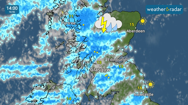
Weather radar at 14:00 on 13.10 showing widespread blue rain bands and lightning across western and central Scotland, with a thunderstorm symbol.
Heavy showers move through in the afternoon for Scotland bringing thunder too.

Tuesday brings heavy, thundery showers to parts of Ireland, Northern Ireland, and later on, Scotland.

Lightning strikes have already been seen in Co. Mayo, Ireland early in the morning where the heavy rain starts the day. This gradually move north-east through Northern Ireland towards Scotland in the afternoon.

While the rain will be heavy at times, the showers shouldn't persist for too long. Accumulations of up to 20 mm are expected north of Glasgow. There are no flood warnings active.

While the thundery showers are mostly in these areas, heavy showers do descend into northern England as far south as the Yorkshire Dales. Elsewhere it's a relatively bright, albeit gusty Tuesday.

Keep track of the showers and lightningWeatherRadar
Ryan Hathaway
More on the topic
Dull start to the week under cloud cover. Little sun to be seen. . . Monday 12 October 2026
Weather map showing extensive cloud over the UK and Ireland, a broad blue rain band approaching western Ireland and temperatures of 12–17°C.
Monday 12 October 2026

Little sun to be seen

Dull start to the week under cloud cover
Windswept Friday as gusts spread wide. Across the UK and Ireland. . . Thursday 8 October 2026
Wind map showing gusts of 40 mph near Dublin, Liverpool and Cardiff, 35 mph near Glasgow and London, and a strong wind warning symbol.
Thursday 8 October 2026

Across the UK and Ireland

Windswept Friday as gusts spread wide
Hurricane threatens the US coast. First storm of the season. . . Thursday 8 October 2026
The WindRadar shows a powerful hurricane off the US Gulf Coast. Wind speeds of 75 miles per hour are being recorded around the centre of the storm.
Thursday 8 October 2026

First storm of the season

Hurricane threatens the US coast
All weather news
This might also interest you
Long-term trends need a pinch of salt. 40 °C in July?. . . Tuesday 30 June 2026
Temperature radar of 2022 heatwave where the all-time temperature record in the UK was set. Warning symbol overlain.
Tuesday 30 June 2026

40 °C in July?

Long-term trends need a pinch of salt
Flooding, gales, and heavy snow. Storm Chandra. . . Tuesday 27 January 2026
Split image showing aerial flooding in a town with muddy water covering roads on the left, and a rural road on the right blocked by heavy snowfall with vans stopped and a person walking in snow.
Tuesday 27 January 2026

Storm Chandra

Flooding, gales, and heavy snow
Bright and warm conditions take hold. Spring-like outlook. . . Thursday 23 April 2026
Split UK map showing warm temperatures up to 21 degrees in orange on the left and clear sunny conditions with temperatures from 12 to 18 degrees on the right, with sun icons across the country.
Thursday 23 April 2026

Spring-like outlook

Bright and warm conditions take hold
All articles
Weather & Radar

Weather & Radar is also available on

Google Play StoreApp Store

Company

Contact us Privacy Policy Legal info Accessibility statement

Services

Uploader

Socials

facebooktwitteryouTubelinkList