Home
Weather Dublin
WeatherRadar
RainfallRadar
TemperatureRadar
WindRadar
LightningRadar
Weather News
Editor's Pick
Discover the app
Weather widget
Contact us
Apps
    Home / Editor's Pick /

    Former hurricane to record-breaking storm - Isaias affecting Europe

11:00
14 October 2026

Isaias affecting Europe
Former hurricane to record storm

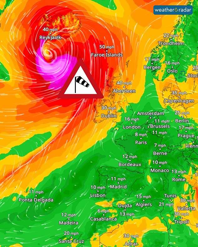
A massive storm system has developed over the North Atlantic. It has formed from the remnants of Hurricane Isaias, which made landfall on the US coast at the weekend.

Over the sea and along the southern coast of Iceland, the storm is reaching wind speeds of around 125 miles per hour.

Did you know?

Within just 24 hours, the air pressure associated with the low-pressure system has fallen by more than 50 hectopascals. We meteorologists call this ‘explosive cyclogenesis’. This is when a low-pressure system intensifies explosively within a short space of time.

The full force of the hurricane will not make landfall. However, Ireland and Scotland will feel the effects of the storm’s outer bands. At the same time, the low-pressure system is affecting wind patterns across large parts of central and south-western Europe.

Our global WindRadar shows the powerful storm system south of Iceland.

With the wind shifting to the south-west, warm air is flowing into Central Europe. As a result, temperatures are rising to around 20°C. In Spain and the south of France, it will get even warmer, with highs of around 30°C.

See the warmest temperatures todayTemperatureRadar
Weather & Radar editorial team
More on the topic
Rain warnings issued in parts of Ireland. North-west takes the brunt. . . Tuesday 13 October 2026
Weather map showing a broad blue rain band over western Ireland and Northern Ireland, with a red heavy rain warning symbol west of Galway.
Tuesday 13 October 2026

North-west takes the brunt

Rain warnings issued in parts of Ireland
Warnings for a windswept Wednesday. Coastal gales. . . Tuesday 13 October 2026
Wind map showing 45 mph near Aberdeen, 40 mph near Glasgow and Cork, and red strong wind warning symbols across western Scotland and Ireland.
Tuesday 13 October 2026

Coastal gales

Warnings for a windswept Wednesday
Severe storms expected in the Med. Risk of flooding. . . Tuesday 13 October 2026
The weather radar and warning map show severe thunderstorms and heavy rain in Greece and western Turkey.
Tuesday 13 October 2026

Risk of flooding

Severe storms expected in the Med
All weather news
This might also interest you
A frozen start to the weekend. Icy conditions. . . Friday 13 February 2026
UK temperature map dated 14.02 showing widespread subzero values in blue shading, with readings such as −4 in Glasgow, −3 in Dublin, and −2 in London, alongside a blue thermometer icon.
Friday 13 February 2026

Icy conditions

A frozen start to the weekend
Historic Storm Éowyn arrives. On this day.... . . Saturday 24 January 2026
Split image showing a person in a yellow jacket struggling against strong winds and heavy rain on a street at night on the left, and an Irish wind forecast map on the right with red and purple shading, gusts up to 75 mph, and a wind warning icon, divided by a curved white line.
Saturday 24 January 2026

On this day...

Historic Storm Éowyn arrives
Storm Chandra makes impact. Severe gales & heavy rain. . . Tuesday 27 January 2026
Split image showing strong winds over the UK on a forecast map and widespread rain and snow on a weather radar map.
Tuesday 27 January 2026

Severe gales & heavy rain

Storm Chandra makes impact
All articles
Weather & Radar

Weather & Radar is also available on

Google Play StoreApp Store

Company

Contact us Privacy Policy Legal info Accessibility statement

Services

Uploader

Socials

facebooktwitteryouTubelinkList