Home
Weather Dublin
WeatherRadar
RainfallRadar
TemperatureRadar
WindRadar
LightningRadar
Weather News
Editor's Pick
Discover the app
Weather widget
Contact us
Apps
    Home / Editor's Pick /

    First Atlantic hurricane: Storm threatens US coast

11:00
8 October 2026

First storm of the season
Hurricane threatens the US coast

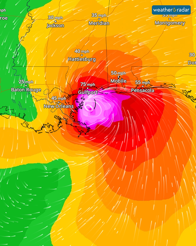
The Atlantic hurricane season, which has been relatively quiet so far, is now picking up pace. Hurricane Isaias has formed in the Gulf of Mexico. It is currently situated around 250 kilometres north of the Mexican coast and is heading towards the United States.

A hurricane warning is already in place for the coasts of Mississippi, Alabama, and north-west Florida. As things stand, Isaias is expected to make landfall in this region on Friday evening (local time) as a major hurricane.

The WindRadar forecast for Saturday night shows Isaias just east of New Orleans.

There is then a risk of gale-force winds, heavy downpours, and severe flooding. There may also be significant disruption to road and air travel.

It took more than four months after the start of the Atlantic hurricane season for Isaias to form, narrowly missing a 121-year-old record. According to the US National Weather Service, the latest first hurricane of a season on record occurred in 1905 – on October 8th that year.

Weather & Radar editorial team

More on the topic

Brazil: A spring full of storms. Rain and flooding. . . Friday 13 November 2026
Split. On the left, a weather map of Brazil showing clouds, rain and lightning. On the right, a thundercloud
Friday 13 November 2026

Rain and flooding

Brazil: A spring full of storms
Storm hits the Iberian Peninsula. Hurricane-force gusts. . . Wednesday 11 November 2026
WindRadar showing a storm warning symbol and areas of strong winds over Portugal, southern Spain and Morocco.
Wednesday 11 November 2026

Hurricane-force gusts

Storm hits the Iberian Peninsula
Why forecasting snow is so tricky. When will snow return?. . . Tuesday 17 November 2026
Split image showing pink snow bands across the Scottish Highlands on a weather map, beside snow-covered orange leaves on a branch.
Tuesday 17 November 2026

When will snow return?

Why forecasting snow is so tricky
All weather news

This might also interest you

Historic Storm Éowyn arrives. On this day.... . . Saturday 24 January 2026
Split image showing a person in a yellow jacket struggling against strong winds and heavy rain on a street at night on the left, and an Irish wind forecast map on the right with red and purple shading, gusts up to 75 mph, and a wind warning icon, divided by a curved white line.
Saturday 24 January 2026

On this day...

Historic Storm Éowyn arrives
A frozen start to the weekend. Icy conditions. . . Friday 13 February 2026
UK temperature map dated 14.02 showing widespread subzero values in blue shading, with readings such as −4 in Glasgow, −3 in Dublin, and −2 in London, alongside a blue thermometer icon.
Friday 13 February 2026

Icy conditions

A frozen start to the weekend
Bright and warm conditions take hold. Spring-like outlook. . . Thursday 23 April 2026
Split UK map showing warm temperatures up to 21 degrees in orange on the left and clear sunny conditions with temperatures from 12 to 18 degrees on the right, with sun icons across the country.
Thursday 23 April 2026

Spring-like outlook

Bright and warm conditions take hold
All articles
Weather & Radar

Weather & Radar is also available on

Google Play StoreApp Store

Company

Contact us Privacy Policy Legal info Accessibility statement

Services

Uploader

Socials

facebooktwitteryouTubelinkList