Home
Weather Dublin
WeatherRadar
RainfallRadar
TemperatureRadar
WindRadar
LightningRadar
Weather News
Editor's Pick
Discover the app
Weather widget
Contact us
Apps
    Home /

    Weekend outlook - More unsettled than the week behind

15:23
29 May 2026

Weekend outlook
More unsettled than the week behind

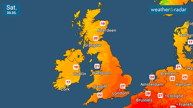
Cooler, but still above-average temperatures for the time of year on Saturday.

The outlook is much more unsettled than we've seen of late, with the heatwave breaking and more widespread rain falling.

On Saturday, it remains relatively cool in Ireland and Scotland with unsettled and often showery weather. Drier with sunny spells further north and east.

Temperatures will again reach around 25 °C and above, highs of around 28 °C expected in the Home Counties.

Into Sunday and it is changeable, and generally cooler, as Atlantic systems become more dominant. Regular and sometimes heavy showers fall in Ireland, into the north and west of the UK.

Away from this, to the east and south, temperatures are remaining above average for the time of year, again at their highest to the south-east of England.

Meanwhile, the north-west is cooler than average, feeling even chillier with that frequent rainfall as we head into June.

London

Th
19
25
Fr
15
27
Sa
15
22
Su
13
20
Mo
15
18
Tu
13
18
We
12
20
Th
12
20
Fr
14
22
Sa
14
22
Su
13
21
Mo
14
22
Tu
13
22
We
14
24
Max (°C)
Min (°C)
moreless

Manchester

Th
13
21
Fr
11
22
Sa
13
18
Su
13
18
Mo
14
16
Tu
13
16
We
11
19
Th
10
17
Fr
12
18
Sa
11
19
Su
11
19
Mo
12
20
Tu
12
20
We
12
20
Max (°C)
Min (°C)
moreless

Dublin

Th
14
22
Fr
12
18
Sa
13
20
Su
14
20
Mo
14
16
Tu
11
17
We
9
17
Th
10
16
Fr
10
17
Sa
9
17
Su
9
17
Mo
10
18
Tu
10
19
We
9
18
Max (°C)
Min (°C)
moreless

Cardiff

Th
14
21
Fr
9
21
Sa
14
19
Su
14
18
Mo
14
17
Tu
12
16
We
12
17
Th
11
17
Fr
13
18
Sa
12
17
Su
12
17
Mo
13
19
Tu
12
19
We
12
20
Max (°C)
Min (°C)
moreless

Edinburgh

Th
14
18
Fr
10
19
Sa
12
18
Su
9
16
Mo
12
18
Tu
12
16
We
10
16
Th
11
17
Fr
12
18
Sa
10
18
Su
10
17
Mo
11
19
Tu
9
18
We
11
17
Max (°C)
Min (°C)
moreless
Weather & Radar editorial team
More on the topic
Heat map centered on London showing intense red temperatures across southeast England, with Heathrow highlighted at 33.5°C and nearby cities around 30–32°C.
Monday 25 May 2026

33.5 °C and still rising

Hottest May day on record
Temperature map of southeast England showing overnight low temperatures, with Kenley highlighted at 21.3°C and surrounding areas in yellow-orange shades indicating mild nighttime conditions.
Tuesday 26 May 2026

May heatwave

Tropical night breaks overnight record
Split image showing a bright rainbow above a residential street on the left and a dramatic ocean sunrise with glowing clouds and reflections on the sea on the right.
Sunday 24 May 2026

Your weather - Your shots

From unsettled to warm and toasty
All weather news
This might also interest you
Temperature map of the UK and western Europe showing warm orange conditions with temperatures above 20°C, alongside thermometer and UV icons indicating strong sunshine and elevated UV levels.
Wednesday 20 May 2026

Sunday peak

UV levels soar over Bank Holiday weekend
Weather map of the USA showing an active thunderstorm front between Kansas City and Minneapolis. Numerous lightning symbols indicate severe thunderstorms, along with a severe weather warning symbol.
Monday 18 May 2026

Tornadoes possible

Dangerous thunderstorm front over the US
Weather map of Europe showing a high-pressure system over Central Europe, low-pressure systems over the Atlantic and Turkey, numerous sun symbols, and temperatures ranging from 4 to over 40 degrees.
Thursday 21 May 2026

Omega block

The weather in Europe is changing
All articles
Weather & Radar

Weather & Radar is also available on

Google Play StoreApp Store

Company

Contact us Privacy Policy Legal info Accessibility statement

Services

Uploader

Socials

facebooktwitteryouTubelinkList