Home
Weather Dublin
WeatherRadar
RainfallRadar
TemperatureRadar
WindRadar
LightningRadar
Weather News
Editor's Pick
Discover the app
Weather widget
Contact us
Apps
    Home / Editor's Pick /

    33.5 °C and still rising - Hottest May day on record

12:29
25 May 2026

33.5 °C and still rising
Hottest May day on record

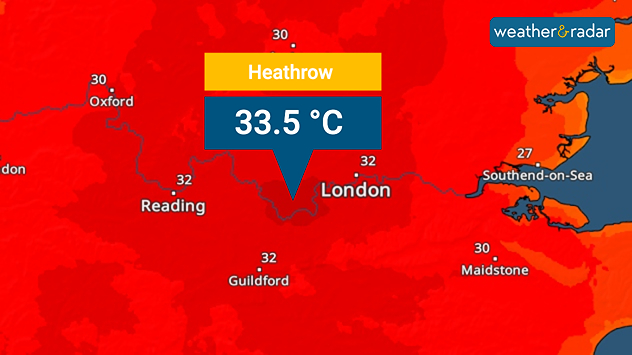
Heat map centered on London showing intense red temperatures across southeast England, with Heathrow highlighted at 33.5°C and nearby cities around 30–32°C.
A new record temperature for the month of May.

It's officially the hottest May day in recorded history after a reading of 33.5 °C in London on Monday.

This high was recorded just after midday, before temperatures reach their peak meaning the final record-high will inch even higher. This passes the existing high of 32.8 °C.

Not only is it the hottest day in May, it's also a new record for any bank holiday Monday, besting the high of 33.3 °C on the August bank holiday in 2019.

Across the UK, heatwave thresholds have been met. Despite the heat there, in Ireland highs are still lower with a high of around 27 °C in Limerick on Monday.

Temperatures must surpass 25 °C for five consecutive days on the Emerald Isle for a heatwave to be declared which is not going to happen. The warmth breaks there on Thursday.

To make the sticky conditions worse, there are water shortages in some areas. In Kent, bottled water stations have been set up with around 500 properties with no water supply.

Daily highs of around 33 °C are expected on the bank holiday Monday with many people out in the strong sunshine. Keep hydrated and apply plenty of sunscreen!

Staying sun safe in the heatwaveread more
Ryan Hathaway
More on the topic
Chance of thundery showers breaking out. Over the coming days. . . Tuesday 18 August 2026
Split weather graphic showing a yellow thunderstorm warning across eastern England alongside radar with heavy showers and lightning near Sheffield, Leicester and East Anglia.
Tuesday 18 August 2026

Over the coming days

Chance of thundery showers breaking out
Drought brings flash flood risks. As rain returns. . . Wednesday 19 August 2026
Weather radar map of the UK and Ireland showing widespread showers, with a rain icon and flood warning symbol highlighting the risk from rainfall.
Wednesday 19 August 2026

As rain returns

Drought brings flash flood risks
Late-summer views as shooting stars fly. Your weather - Your shots. . . Sunday 23 August 2026
Split image showing a meteor streaking through a star-filled night sky on the left and wispy white cirrus clouds sweeping across a vivid blue daytime sky on the right.
Sunday 23 August 2026

Your weather - Your shots

Late-summer views as shooting stars fly
All weather news
This might also interest you
Storm Chandra makes impact. Severe gales & heavy rain. . . Tuesday 27 January 2026
Split image showing strong winds over the UK on a forecast map and widespread rain and snow on a weather radar map.
Tuesday 27 January 2026

Severe gales & heavy rain

Storm Chandra makes impact
New records for England and Wales. Broken again tomorrow?. . . Thursday 25 June 2026
Temperature map of southwest Britain on 25.06 showing extreme heat across southern Wales and southwest England, with Bute Park in Cardiff highlighted at 34.2°C and Yeovilton at 36.4°C amid widespread deep red heat zones.
Thursday 25 June 2026

Broken again tomorrow?

New records for England and Wales
Historic Storm Éowyn arrives. On this day.... . . Saturday 24 January 2026
Split image showing a person in a yellow jacket struggling against strong winds and heavy rain on a street at night on the left, and an Irish wind forecast map on the right with red and purple shading, gusts up to 75 mph, and a wind warning icon, divided by a curved white line.
Saturday 24 January 2026

On this day...

Historic Storm Éowyn arrives
All articles
Weather & Radar

Weather & Radar is also available on

Google Play StoreApp Store

Company

Contact us Privacy Policy Legal info Accessibility statement

Services

Uploader

Socials

facebooktwitteryouTubelinkList