Home
Weather Dublin
WeatherRadar
RainfallRadar
TemperatureRadar
WindRadar
LightningRadar
Weather News
Editor's Pick
Discover the app
Weather widget
Contact us
Apps
    Home /

    Weather outlook - Much cloudier week with rain in parts

04:11
21 July 2026

Weather outlook
Much cloudier week with rain in parts

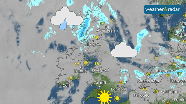
Satellite weather map of the UK and Ireland showing rain and showers across northern Scotland and nearby Atlantic waters, increasing cloud over eastern Britain, and sunny conditions across southern England and much of Ireland. Temperatures range from 17°C in Ireland and northeast Scotland to 23°C in southeast England.

The week ahead brings a much duller outlook compared to the bright sunshine of the month so far, with showers and drizzle in parts.

From Tuesday, varying cloud cover spreads across the UK and Ireland. In parts, there will be sunny spells, particularly for the morning and late afternoon.

Ireland remains almost completely covered up to Friday with only bright spells towards the south and east coasts.

Aside from the cloud cover, conditions remain relatively settled thanks to the continued influence of high pressure. The occassional shower may form, particularly over Scotland and Northern Ireland later in the week.

Temperatures have finally fallen below heatwave thresholds for many, remaining around the low to mid-20s quite widely, but the upper-teens across Scotland.

Meanwhile, winds remain calm and move into a northerly flow bringing cooler air south from the Arctic. This keeps temperatures around the northern coastlines a little lower than elsewhere.

London

Tu
16
24
We
16
26
Th
15
25
Fr
17
27
Sa
17
25
Su
17
25
Mo
17
26
Tu
17
27
We
17
27
Th
17
28
Fr
18
29
Sa
17
26
Su
17
28
Mo
18
29
Max (°C)
Min (°C)
moreless

Manchester

Tu
13
23
We
15
23
Th
15
22
Fr
13
21
Sa
15
19
Su
14
22
Mo
14
21
Tu
14
22
We
14
22
Th
14
22
Fr
14
22
Sa
14
22
Su
13
22
Mo
14
23
Max (°C)
Min (°C)
moreless

Dublin

Tu
14
20
We
14
20
Th
14
20
Fr
12
23
Sa
16
20
Su
14
21
Mo
13
21
Tu
12
21
We
12
20
Th
11
20
Fr
12
21
Sa
12
20
Su
12
20
Mo
13
21
Max (°C)
Min (°C)
moreless

Edinburgh

Tu
11
25
We
14
22
Th
14
22
Fr
14
20
Sa
14
21
Su
13
20
Mo
13
21
Tu
13
21
We
14
20
Th
13
22
Fr
12
20
Sa
12
20
Su
13
21
Mo
13
21
Max (°C)
Min (°C)
moreless

Cardiff

Tu
15
26
We
14
25
Th
15
25
Fr
13
24
Sa
15
21
Su
15
23
Mo
16
24
Tu
15
23
We
15
23
Th
14
23
Fr
15
23
Sa
16
24
Su
14
22
Mo
15
23
Max (°C)
Min (°C)
moreless
Weather & Radar editorial team
More on the topic
Sea fog rolls into Pembrokeshire. Unique summer scene. . . Tuesday 14 July 2026
Thick sea fog rolling inland over a sunlit bay, with sparkling water, trees and garden in the foreground, and a hill rising above the fog under a clear blue sky.
Tuesday 14 July 2026

Unique summer scene

Sea fog rolls into Pembrokeshire
Marine heatwave could affect our weather too. Wetter days to come?. . . Wednesday 15 July 2026
Wednesday 15 July 2026

Wetter days to come?

Marine heatwave could affect our weather too
Fiery summer snaps and video moments. Your weather - Your shots. . . Sunday 19 July 2026
Split image showing vivid orange clouds glowing at sunset on the left and bright sunbeams streaming through scattered clouds above a rocky coastline and calm sea on the right.
Sunday 19 July 2026

Your weather - Your shots

Fiery summer snaps and video moments
All weather news
This might also interest you
Heatwave versus storm system. Contrasts in Europe. . . Tuesday 7 July 2026
A temperature map of Europe showing a major heatwave in the south-west and significantly cooler air in the north. Two thermometer symbols illustrate the stark contrast in temperature.
Tuesday 7 July 2026

Contrasts in Europe

Heatwave versus storm system
Heatwave keeps a firm grip on Europe. Around 40°C in places. . . Monday 13 July 2026
A collage featuring a temperature radar map of Europe and a fire-fighting aircraft in action over a forest fire. In the centre, a heat symbol warns of persistently high temperatures.
Monday 13 July 2026

Around 40°C in places

Heatwave keeps a firm grip on Europe
Very high UV levels during the heatwave. Sun cream at the ready!. . . Wednesday 8 July 2026
Split graphic showing a UK temperature map with hot conditions across England and Wales, temperatures reaching 32 °C near London, and a UV warning icon on the left, alongside a person applying sunscreen in bright sunshine on the right.
Wednesday 8 July 2026

Sun cream at the ready!

Very high UV levels during the heatwave
All articles
Weather & Radar

Weather & Radar is also available on

Google Play StoreApp Store

Company

Contact us Privacy Policy Legal info Accessibility statement

Services

Uploader

Socials

facebooktwitteryouTubelinkList