Home
Weather Dublin
WeatherRadar
RainfallRadar
TemperatureRadar
WindRadar
LightningRadar
Weather News
Editor's Pick
Discover the app
Weather widget
Contact us
Apps
    Home / Editor's Pick /

    Wetter days to come? - Marine heatwave could affect our weather

09:23
15 July 2026

Wetter days to come?
Marine heatwave could affect our weather too

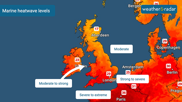
Marine heatwave map showing waters around the UK and Ireland alongside nearby Europe, with sea heatwave levels ranging from around northern Britain to moderate to strong west of Ireland, severe to extreme in the English Channel, and strong to severe in the southern North Sea.
Early July marine heatwave levels around the UK and Ireland.

Sea temperatures around the UK are higher than usual, with some areas seeing an extreme marine heatwave. This deviation from the norm will have consequences for our weather too.

Since early July, sea surface temperatures across north-western Europe, including the UK and Ireland, have been experiencing strong to severe marine heatwaves.

Sea surface anomalies off the coasts of Wales and England have reached as high as 5°C above average, while more widely temperatures are around 2°C above normal for the time of year.

How does a marine heatwave affect our weather?

While the immediate impacts of heatwaves in the water are felt by the marine life around our coasts, the unusually warm seas can also have a knock-on effect on our weather.

Over the coming weeks, elevated sea surface temperatures can result in higher humidity, warmer nights without as cooling sea breezes become less effective, heavier rainfall when frontal systems return, and stronger thunderstorms if conditions are right.

While there is little rainfall in the forecast right now, any system that does arrive will likely be enhanced thanks to the warmer and more humid air it travels over en-route to the UK and Ireland.

June heatwave also warmed the watersread more
Ryan Hathaway
More on the topic
Cooler nights on the horizon. For parts of Europe. . . Thursday 6 August 2026
Temperature Radar showing the night-time lows in Central Europe. Cooler air is reaching the west and north in particular, whilst the south-east remains significantly warmer.
Thursday 6 August 2026

For parts of Europe

Cooler nights on the horizon
Japan braces itself for Typhoon Dolphin. Landslides feared. . . Wednesday 5 August 2026
Weather map showing a typhoon south of Japan. The centre of the storm is over the Pacific and is moving westwards. The coloured wind fields indicate its high intensity.
Wednesday 5 August 2026

Landslides feared

Japan braces itself for Typhoon Dolphin
Huge hailstones in Poland. Severe weather hits towns. . . Friday 7 August 2026
Friday 7 August 2026

Severe weather hits towns

Huge hailstones in Poland
All weather news
This might also interest you
Long-term trends need a pinch of salt. 40 °C in July?. . . Tuesday 30 June 2026
Temperature radar of 2022 heatwave where the all-time temperature record in the UK was set. Warning symbol overlain.
Tuesday 30 June 2026

40 °C in July?

Long-term trends need a pinch of salt
Flooding, gales, and heavy snow. Storm Chandra. . . Tuesday 27 January 2026
Split image showing aerial flooding in a town with muddy water covering roads on the left, and a rural road on the right blocked by heavy snowfall with vans stopped and a person walking in snow.
Tuesday 27 January 2026

Storm Chandra

Flooding, gales, and heavy snow
Turbulent weather in the Canary Islands. Storm and rain. . . Friday 12 December 2025
Weather graphic showing rain and wind fields over the Canary Islands and a central warning symbol.
Friday 12 December 2025

Storm and rain

Turbulent weather in the Canary Islands
All articles
Weather & Radar

Weather & Radar is also available on

Google Play StoreApp Store

Company

Contact us Privacy Policy Legal info Accessibility statement

Services

Uploader

Socials

facebooktwitteryouTubelinkList