Home
Weather Dublin
WeatherRadar
RainfallRadar
TemperatureRadar
WindRadar
LightningRadar
Weather News
Editor's Pick
Discover the app
Weather widget
Contact us
Apps
    Home / Editor's Pick /

    Your weather - Your shots - Fiery summer snaps and video moments

14:00
19 July 2026

Your weather - Your shots
Fiery summer snaps and video moments

Orange and pink sunset clouds glowing above a rural landscape, with silhouetted trees, rolling hills, and evergreen branches framing the colourful evening sky.
Dramatic orange and gold mammatus clouds glowing at sunset above rooftops, with pouch-shaped cloud formations, layered storm clouds, and vivid evening light illuminating the underside of the sky.
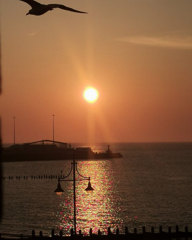
Golden sun setting over the sea beside a harbor breakwater and lighthouse, with shimmering reflections on the water, silhouetted lamp posts, and a seagull flying across the glowing evening sky.
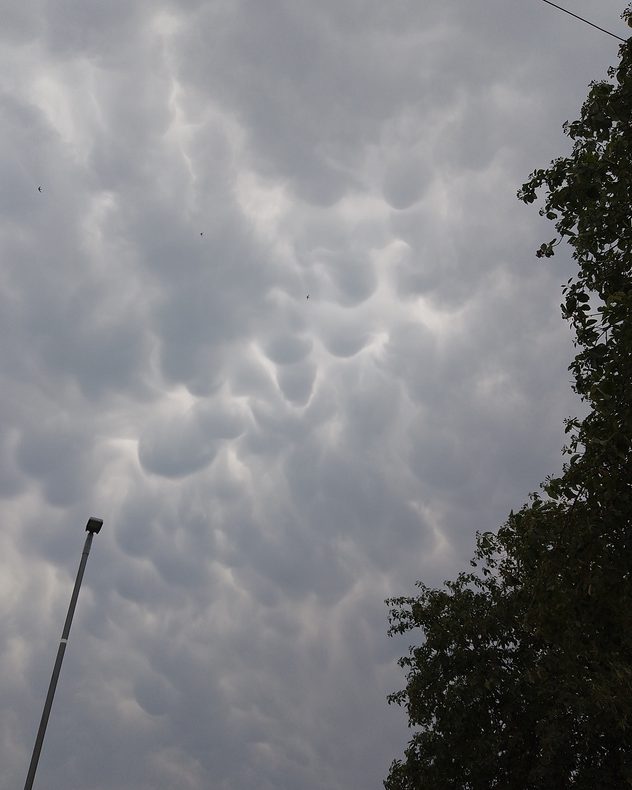
Dark gray mammatus clouds hanging beneath a thunderstorm, with rounded pouch-like formations covering the sky above trees and a streetlight, creating a dramatic severe weather scene.
Bright sun shining through scattered altocumulus clouds above a rocky coastline, with crepuscular rays illuminating the calm sea, rugged cliffs, and a large offshore sea stack.
Soft pink and orange twilight sky above silhouetted trees and rooftops, with wispy high clouds stretching across the fading evening light over a quiet residential area.
Calm lake reflecting lush green trees beneath a clear blue sky, with reeds and overhanging branches framing the water, sunlit grass, and a few white waterbirds on the far bank.
1/7
The last of the daylight at sunset in Templemartin, Co. Cork. - © Jacky Quirke

Vibrant sunsets, fascinating clouds, and calm summer shots, the temperatures have fallen and the pleasant days are back on camera.

Of course, it's not just the stills that caught the eye but the weather moments captured on video too!

Want to get involved? Send in your pictures via the Uploader, or record your own weather moment with our video feature and submit directly to us, or share with your friends and family.

Weather & Radar editorial team
More on the topic
Severe weather spreads across Europe. Lightning, hail, gales. . . Wednesday 15 July 2026
Split image showing a dramatic supercell thunderstorm with dark rotating clouds over open countryside on the left, and a severe thunderstorm warning map on the right highlightning elevated storm risk across parts of central Europe, including northern Italy, Switzerland, eastern France, and southern Germany.
Wednesday 15 July 2026

Lightning, hail, gales

Severe weather spreads across Europe
Sea fog rolls into Pembrokeshire. Unique summer scene. . . Tuesday 14 July 2026
Thick sea fog rolling inland over a sunlit bay, with sparkling water, trees and garden in the foreground, and a hill rising above the fog under a clear blue sky.
Tuesday 14 July 2026

Unique summer scene

Sea fog rolls into Pembrokeshire
Violent storms impacting northern Italy. Hail and storm damage. . . Thursday 16 July 2026
A weather map showing thunderstorms over northern Italy and a photograph of large hailstones in a hand.
Thursday 16 July 2026

Hail and storm damage

Violent storms impacting northern Italy
All weather news
This might also interest you
Flooding, gales, and heavy snow. Storm Chandra. . . Tuesday 27 January 2026
Split image showing aerial flooding in a town with muddy water covering roads on the left, and a rural road on the right blocked by heavy snowfall with vans stopped and a person walking in snow.
Tuesday 27 January 2026

Storm Chandra

Flooding, gales, and heavy snow
New records for England and Wales. Broken again tomorrow?. . . Thursday 25 June 2026
Temperature map of southwest Britain on 25.06 showing extreme heat across southern Wales and southwest England, with Bute Park in Cardiff highlighted at 34.2°C and Yeovilton at 36.4°C amid widespread deep red heat zones.
Thursday 25 June 2026

Broken again tomorrow?

New records for England and Wales
Super Typhoon Bavi threatens Taiwan. Up to 1,000 mm of rain. . Weather Videos. Wednesday 8 July 2026
The image shows an intense tropical cyclone over the western Pacific, east of Taiwan and the Philippines. The centre of the system is depicted as a light purple and white vortex with a clearly visible eye, surrounded by a ring of red and orange areas indicating the strongest wind speeds. A white arrow marks the typhoon’s predicted track towards the north-west, in the direction of Taiwan. To the west of the storm lie the Philippines, with the cities of Manila and Cebu; to the north of these lies Taiwan, with Taipei. Further west, the Chinese coast, including Hong Kong, and parts of Vietnam can be seen. The coloured wind map shows predominantly green areas outside the storm’s core, indicating significantly weaker winds. White streamlines illustrate the typhoon’s anti-clockwise circulation in the Northern Hemisphere. The highest wind speeds are concentrated around the eye of the cyclone.
Weather VideosWednesday 8 July 2026

Up to 1,000 mm of rain

Super Typhoon Bavi threatens Taiwan
All articles
Weather & Radar

Weather & Radar is also available on

Google Play StoreApp Store

Company

Contact us Privacy Policy Legal info Accessibility statement

Services

Uploader

Socials

facebooktwitteryouTubelinkList