Home
Weather Dublin
WeatherRadar
RainfallRadar
TemperatureRadar
WindRadar
LightningRadar
Weather News
Editor's Pick
Discover the app
Weather widget
Contact us
Apps
    Home / Editor's Pick /

    Stormy day in parts of the UK & Ireland

10:18
4 August 2026

Lightning potential
Stormy day in parts of the UK & Ireland

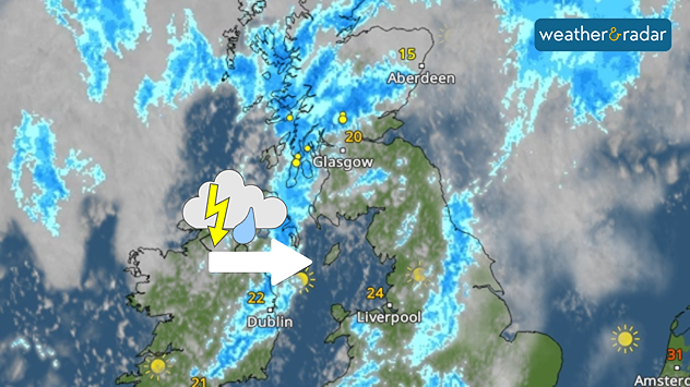
Satellite weather map of the UK and Ireland showing thunderstorms moving east from Ireland into western Scotland, highlighted by a thunderstorm icon and directional arrow. Heavy rain and lightning affect western Scotland, while temperatures range from 15°C in northeast Scotland to 24°C in northwest England and 22°C in Dublin.
Thundery outbreaks start in Ireland Tuesday morning before pushing east.

Tuesday sees heavy showers which turn thundery at times through the day, mostly through parts of Scotland after passing Ireland in the morning.

In Northern Ireland, between 20 to 30 mm of rain could fall in heavy showers lasting a couple of hours. The responsible band is moving east into the UK later in the day.

The showers can also turn thundery. North-west Ireland into Northern Ireland saw thunderstorms to start the day.

From the afternoon, the thundery potential moves into Scotland and parts of central England.

Weather warnings cover eastern Scotland in a stretch from Glasgow to Aberdeen with Wednesday warnings also issued for central to eastern Scotland. Both with low likelihoods.

Responsible for the shift in conditions is an area of low pressure situated just to the west of Scotland.

Ryan Hathaway
More on the topic
Europe’s seas are unusually warm. Up to 30 degrees. . . Friday 31 July 2026
Friday 31 July 2026

Up to 30 degrees

Europe’s seas are unusually warm
June records rise after verification. Multiple new highs. . . Thursday 30 July 2026
Temperature map of the UK and Ireland highlighting verified June temperature records, with 38°C in England, 35.1°C in Wales, and 30.8°C in Ireland. A large thermometer icon emphasizes record-breaking June heat across the UK.
Thursday 30 July 2026

Multiple new highs

June records rise after verification
Heavier rainfall over the week for some. Ireland & Scotland. . . Tuesday 28 July 2026
Split image showing a Europe rainfall accumulation forecast map on the left with the highest totals across the UK, Ireland, and Scandinavia, and a satellite weather map on the right with a broad band of rain stretching across Ireland, Scotland, and northern Britain, highlighted by a rain cloud icon.
Tuesday 28 July 2026

Ireland & Scotland

Heavier rainfall over the week for some
All weather news
This might also interest you
Long-term trends need a pinch of salt. 40 °C in July?. . . Tuesday 30 June 2026
Temperature radar of 2022 heatwave where the all-time temperature record in the UK was set. Warning symbol overlain.
Tuesday 30 June 2026

40 °C in July?

Long-term trends need a pinch of salt
Flooding, gales, and heavy snow. Storm Chandra. . . Tuesday 27 January 2026
Split image showing aerial flooding in a town with muddy water covering roads on the left, and a rural road on the right blocked by heavy snowfall with vans stopped and a person walking in snow.
Tuesday 27 January 2026

Storm Chandra

Flooding, gales, and heavy snow
Super Typhoon Bavi threatens Taiwan. Up to 1,000 mm of rain. . Weather Videos. Wednesday 8 July 2026
The image shows an intense tropical cyclone over the western Pacific, east of Taiwan and the Philippines. The centre of the system is depicted as a light purple and white vortex with a clearly visible eye, surrounded by a ring of red and orange areas indicating the strongest wind speeds. A white arrow marks the typhoon’s predicted track towards the north-west, in the direction of Taiwan. To the west of the storm lie the Philippines, with the cities of Manila and Cebu; to the north of these lies Taiwan, with Taipei. Further west, the Chinese coast, including Hong Kong, and parts of Vietnam can be seen. The coloured wind map shows predominantly green areas outside the storm’s core, indicating significantly weaker winds. White streamlines illustrate the typhoon’s anti-clockwise circulation in the Northern Hemisphere. The highest wind speeds are concentrated around the eye of the cyclone.
Weather VideosWednesday 8 July 2026

Up to 1,000 mm of rain

Super Typhoon Bavi threatens Taiwan
All articles
Weather & Radar

Weather & Radar is also available on

Google Play StoreApp Store

Company

Contact us Privacy Policy Legal info Accessibility statement

Services

Uploader

Socials

facebooktwitteryouTubelinkList