Home
Weather Dublin
WeatherRadar
RainfallRadar
TemperatureRadar
WindRadar
LightningRadar
Weather News
Editor's Pick
Discover the app
Weather widget
Contact us
Apps
    Home / Editor's Pick /

    Wettest week in England for two years

15:23
29 October 2026

Stormy assistance
Wettest week in England for two years

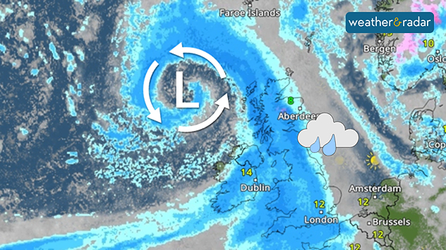
Weather map showing a swirling Atlantic low north-west of Scotland, with blue rain bands across the UK, Ireland, and North Sea and temperatures of 8 to 14°C
Storm Boelo helped fuel the wettest week in England for two years.

Storms Austen and Boelo helped deliver the wettest week in two years, according to provisional data from the Environment Agency.

Between Wednesday, October 21st and Tuesday, October 27th, an average of 55 mm of rainfall accumulated across England. Most notably, the south-west saw 87 mm within the week, marking the wettest reporting week since October 2024.

River flows increased at all but two of the Environment Agency's reporting sites compared to the previous week with rainfall across England as a whole now 111% of the long-term average for October.

Despite the heavy rain, it is not enough to lift drought conditions which still cover much of the country, with a severe drought status still covering swathes of the south-west.

The autumn and winter months provide time for reservoirs and groundwater to replenish, but with three droughts in five years, the period of recovery is increasingly no longer sufficient before the next summer arrives, especially increasingly hotter ones.

For now, a more settled period appears to be on the horizon as high-pressure takes over. Keep an eye on showers via the WeatherRadar, but more sustained rainfall is beginning to move away again.

Ryan Hathaway

More on the topic

Widespread fog grips Thursday morning. Take care on the roads. . . Wednesday 28 October 2026
Split image showing a fog forecast across southern England with temperatures of 8–9°C, alongside cars driving through dense mist on a sunlit road.
Wednesday 28 October 2026

Take care on the roads

Widespread fog grips Thursday morning
Stormy winds finally easing. By the end of the week. . . Tuesday 27 October 2026
Split wind maps showing winds of 25–40 mph across the UK and Ireland easing to 7–15 mph, with a white arrow indicating the change.
Tuesday 27 October 2026

By the end of the week

Stormy winds finally easing
Preparing for the storms. What to do now. . . Thursday 22 October 2026
Split image showing Storm Austen winds up to 65 mph near Brest and 55 mph near Plymouth, alongside fallen tree branches on a cordoned-off park path.
Thursday 22 October 2026

What to do now

Preparing for the storms
All weather news

This might also interest you

Seasonal warmth between spring thunder. Your weather - Your shots. . . Sunday 19 April 2026
Split image showing coastal sunset with layered lenticular clouds over rooftops and palm trees on the left, and a green valley with river and hills under soft daylight on the right.
Sunday 19 April 2026

Your weather - Your shots

Seasonal warmth between spring thunder
Bright and warm conditions take hold. Spring-like outlook. . . Thursday 23 April 2026
Split UK map showing warm temperatures up to 21 degrees in orange on the left and clear sunny conditions with temperatures from 12 to 18 degrees on the right, with sun icons across the country.
Thursday 23 April 2026

Spring-like outlook

Bright and warm conditions take hold
New records for England and Wales. Broken again tomorrow?. . . Thursday 25 June 2026
Temperature map of southwest Britain on 25.06 showing extreme heat across southern Wales and southwest England, with Bute Park in Cardiff highlighted at 34.2°C and Yeovilton at 36.4°C amid widespread deep red heat zones.
Thursday 25 June 2026

Broken again tomorrow?

New records for England and Wales
All articles
Weather & Radar

Weather & Radar is also available on

Google Play StoreApp Store

Company

Contact us Privacy Policy Legal info Accessibility statement

Services

Uploader

Socials

facebooktwitteryouTubelinkList