Home
Weather Dublin
WeatherRadar
RainfallRadar
TemperatureRadar
WindRadar
LightningRadar
Weather News
Editor's Pick
Discover the app
Weather widget
Contact us
Apps
    Home / Editor's Pick /

    Overnight low drops - More comfortable night's sleep

10:09
5 August 2026

Overnight low drops
More comfortable night's sleep

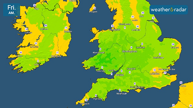
Friday morning temperature map of the UK and Ireland showing cool early conditions, with temperatures generally between 7°C and 13°C. Lowest values are around 7°C in parts of southwest England and South Wales, while Ireland ranges from 9°C to 11°C and northern Scotland reaches around 10°C.
Single digits seen on the TemperatureRadar's lows reflects the cooler night into Friday.

While we didn't quite reach the threshold for tropical nights this time, it has been quite uncomfortable for many recently. Now, overnight temperatures are cooling.

From Wednesday evening, daily lows fall to single digits across large parts of Wales, central to south-western England, and the south of Ireland.

Further north, overnight temperatures did not reach the same uncomfortable highs as elsewhere but still sees lows drop from the mid-teens to around 10°C.

The drop reflects a general trend for the rest of the week with a slightly cooler feel in the air.

Into the weekend, conditions change again with temperatures rising by Saturday into the new week with a renewed burst of heat.

Keep an eye on the TemperatureRadar as we get closer, and check the 14-day weather on the home screen for a longer outlook.

London

We
19
25
Th
14
23
Fr
13
26
Sa
15
27
Su
19
26
Mo
15
24
Tu
17
26
We
19
28
Th
18
28
Fr
18
28
Sa
18
28
Su
18
27
Mo
18
27
Tu
17
25
Max (°C)
Min (°C)
moreless

Manchester

We
14
18
Th
13
17
Fr
9
20
Sa
10
22
Su
15
20
Mo
12
21
Tu
12
23
We
16
26
Th
17
25
Fr
15
23
Sa
14
23
Su
14
22
Mo
15
23
Tu
13
21
Max (°C)
Min (°C)
moreless

Dublin

We
14
18
Th
10
19
Fr
11
21
Sa
11
19
Su
14
19
Mo
10
18
Tu
12
21
We
15
24
Th
14
23
Fr
12
21
Sa
13
21
Su
13
21
Mo
12
22
Tu
12
20
Max (°C)
Min (°C)
moreless

Edinburgh

We
15
18
Th
12
17
Fr
11
19
Sa
13
20
Su
14
19
Mo
12
17
Tu
12
20
We
14
22
Th
15
23
Fr
13
21
Sa
14
22
Su
13
21
Mo
13
21
Tu
12
20
Max (°C)
Min (°C)
moreless

Cardiff

We
17
21
Th
11
21
Fr
7
22
Sa
11
24
Su
17
22
Mo
12
20
Tu
14
24
We
16
25
Th
16
24
Fr
15
23
Sa
16
24
Su
16
24
Mo
16
24
Tu
15
23
Max (°C)
Min (°C)
moreless
Ryan Hathaway
More on the topic
Vibrant skies for the last week of July. Your weather - Your shots. . . Sunday 2 August 2026
Split image showing a golden-orange countryside sunset with silhouetted trees and birds on the left, and glowing blue-white noctilucent clouds rippling across the twilight sky above trees and a lake on the right.
Sunday 2 August 2026

Your weather - Your shots

Vibrant skies for the last week of July
Stormy day in parts of the UK & Ireland. Lightning potential. . . Tuesday 4 August 2026
Satellite and lightning map of Scotland showing widespread rain and thunderstorms across the Highlands and western Scotland, with lightning strikes around the west coast and Hebrides. A thunderstorm icon highlights the active weather, while temperatures range from 15°C in Aberdeen to 24°C in Newcastle.
Tuesday 4 August 2026

Lightning potential

Stormy day in parts of the UK & Ireland
Stronger winds make a return. Low pressure influence. . . Tuesday 4 August 2026
Wind forecast map of the UK and Ireland showing a low-pressure system north of Scotland, a windsock icon highlighting blustery conditions, and widespread winds of 30–40 mph across the British Isles, with the strongest winds around Ireland and northern Britain.
Tuesday 4 August 2026

Low pressure influence

Stronger winds make a return
All weather news
This might also interest you
Long-term trends need a pinch of salt. 40 °C in July?. . . Tuesday 30 June 2026
Temperature radar of 2022 heatwave where the all-time temperature record in the UK was set. Warning symbol overlain.
Tuesday 30 June 2026

40 °C in July?

Long-term trends need a pinch of salt
Storm Chandra makes impact. Severe gales & heavy rain. . . Tuesday 27 January 2026
Split image showing strong winds over the UK on a forecast map and widespread rain and snow on a weather radar map.
Tuesday 27 January 2026

Severe gales & heavy rain

Storm Chandra makes impact
Flooding, gales, and heavy snow. Storm Chandra. . . Tuesday 27 January 2026
Split image showing aerial flooding in a town with muddy water covering roads on the left, and a rural road on the right blocked by heavy snowfall with vans stopped and a person walking in snow.
Tuesday 27 January 2026

Storm Chandra

Flooding, gales, and heavy snow
All articles
Weather & Radar

Weather & Radar is also available on

Google Play StoreApp Store

Company

Contact us Privacy Policy Legal info Accessibility statement

Services

Uploader

Socials

facebooktwitteryouTubelinkList