Home
Weather Dublin
WeatherRadar
RainfallRadar
TemperatureRadar
WindRadar
LightningRadar
Weather News
Editor's Pick
Discover the app
Weather widget
Contact us
Apps
    Home / Editor's Pick /

    Low pressure influence - Stronger winds make a return

14:00
4 August 2026

Low pressure influence
Stronger winds make a return

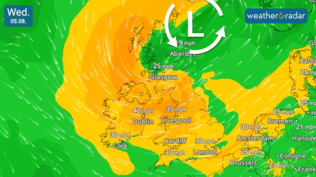
Wind forecast map of the UK and Ireland on Wednesday 05.08 showing a low-pressure system north of Scotland, with widespread winds of 25–40 mph across the British Isles. Strongest winds reach around 40 mph in Ireland and 35 mph across northern England, highlighted by airflow streamlines.
Stronger winds spread on Wednesday thanks to influence from a low-pressure system.

Gusting winds spread across parts of the UK and Ireland this week, with gusts potentially reaching up to 50 mph for some.

Stronger winds begin to build overnight into Wednesday as a low-pressure system moves from the west of Scotland to a position off the north-east coast.

By midday Wednesday, gusts of around 40 mph (65 km/h) are expected around the Irish Sea, possibly stronger in exposed coastal areas.

Later, similarly powerful gusts extend further, up to 45 mph in northern England and stronger still over higher ground including the Lake District and the North York Moors.

The blustery day ends with winds easing from the west as the responsible low continues its trajectory towards Norway, bringing its stronger gusts to Scandinavia and north-west Europe.

Have plans outdoors? Keep an eye on the WindRadar for the latest outlook, and the WeatherRadar for rainfall also falling.

Ryan Hathaway
More on the topic
Heavier rainfall over the week for some. Ireland & Scotland. . . Tuesday 28 July 2026
Split image showing a Europe rainfall accumulation forecast map on the left with the highest totals across the UK, Ireland, and Scandinavia, and a satellite weather map on the right with a broad band of rain stretching across Ireland, Scotland, and northern Britain, highlighted by a rain cloud icon.
Tuesday 28 July 2026

Ireland & Scotland

Heavier rainfall over the week for some
June records rise after verification. Multiple new highs. . . Thursday 30 July 2026
Temperature map of the UK and Ireland highlighting verified June temperature records, with 38°C in England, 35.1°C in Wales, and 30.8°C in Ireland. A large thermometer icon emphasizes record-breaking June heat across the UK.
Thursday 30 July 2026

Multiple new highs

June records rise after verification
Half of England now in drought. Joining North Wales. . . Wednesday 29 July 2026
Dry section of the River Thames beneath a small stone bridge, with the riverbed exposed and cracked after prolonged, dry weather, while a person walks along the roadside above.
Wednesday 29 July 2026

Joining North Wales

Half of England now in drought
All weather news
This might also interest you
Bright and warm conditions take hold. Spring-like outlook. . . Thursday 23 April 2026
Split UK map showing warm temperatures up to 21 degrees in orange on the left and clear sunny conditions with temperatures from 12 to 18 degrees on the right, with sun icons across the country.
Thursday 23 April 2026

Spring-like outlook

Bright and warm conditions take hold
Seasonal warmth between spring thunder. Your weather - Your shots. . . Sunday 19 April 2026
Split image showing coastal sunset with layered lenticular clouds over rooftops and palm trees on the left, and a green valley with river and hills under soft daylight on the right.
Sunday 19 April 2026

Your weather - Your shots

Seasonal warmth between spring thunder
Long-term trends need a pinch of salt. 40 °C in July?. . . Tuesday 30 June 2026
Temperature radar of 2022 heatwave where the all-time temperature record in the UK was set. Warning symbol overlain.
Tuesday 30 June 2026

40 °C in July?

Long-term trends need a pinch of salt
All articles
Weather & Radar

Weather & Radar is also available on

Google Play StoreApp Store

Company

Contact us Privacy Policy Legal info Accessibility statement

Services

Uploader

Socials

facebooktwitteryouTubelinkList