Home
Weather Dublin
WeatherRadar
RainfallRadar
TemperatureRadar
WindRadar
LightningRadar
Weather News
Editor's Pick
Discover the app
Weather widget
Contact us
Apps
    Home / Editor's Pick /

    Japan braces for Typhoon Dolphin

10:00
5 August 2026

Landslides feared
Japan braces itself for Typhoon Doplhin

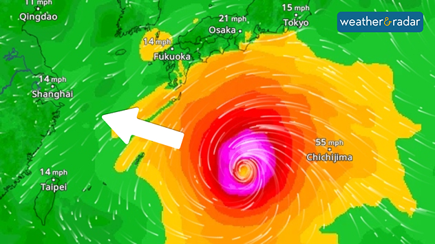
Typhoon Dolphin is heading towards the Ryukyu Islands in southern Japan. From Thursday onwards, Okinawa and the Amami Islands in particular are at risk of wind gusts exceeding 125 miles per hour, torrential rain and waves several metres high.

Further north, in the region affected by last week’s earthquake, heavy rain and storms are also expected.

Our global WindRadar shows the powerful typhoon in the Western Pacific.

In the area around Kumamoto, even small amounts of rain could trigger landslides with soil severely loosened by the earthquake.

Rapid intensification of the storm

Typhoon Dolphin has intensified from a tropical storm to a Category 5 super typhoon in the space of just two days. This rapid intensification was facilitated by very warm sea water and low wind shear.

Did you know?

Wind shear describes the change in wind speed and wind direction with altitude. If the wind direction and wind speed change significantly compared with ground level, the wind shear is high.

Although the cyclone has now weakened slightly, it remains very dangerous.

Weather & Radar editorial team
More on the topic
Stronger winds make a return. Low pressure influence. . . Tuesday 4 August 2026
Wind forecast map of the UK and Ireland showing a low-pressure system north of Scotland, a windsock icon highlighting blustery conditions, and widespread winds of 30–40 mph across the British Isles, with the strongest winds around Ireland and northern Britain.
Tuesday 4 August 2026

Low pressure influence

Stronger winds make a return
Vibrant skies for the last week of July. Your weather - Your shots. . . Sunday 2 August 2026
Split image showing a golden-orange countryside sunset with silhouetted trees and birds on the left, and glowing blue-white noctilucent clouds rippling across the twilight sky above trees and a lake on the right.
Sunday 2 August 2026

Your weather - Your shots

Vibrant skies for the last week of July
Stormy day in parts of the UK & Ireland. Lightning potential. . . Tuesday 4 August 2026
Satellite and lightning map of Scotland showing widespread rain and thunderstorms across the Highlands and western Scotland, with lightning strikes around the west coast and Hebrides. A thunderstorm icon highlights the active weather, while temperatures range from 15°C in Aberdeen to 24°C in Newcastle.
Tuesday 4 August 2026

Lightning potential

Stormy day in parts of the UK & Ireland
All weather news
This might also interest you
Long-term trends need a pinch of salt. 40 °C in July?. . . Tuesday 30 June 2026
Temperature radar of 2022 heatwave where the all-time temperature record in the UK was set. Warning symbol overlain.
Tuesday 30 June 2026

40 °C in July?

Long-term trends need a pinch of salt
Super Typhoon Bavi threatens Taiwan. Up to 1,000 mm of rain. . Weather Videos. Wednesday 8 July 2026
The image shows an intense tropical cyclone over the western Pacific, east of Taiwan and the Philippines. The centre of the system is depicted as a light purple and white vortex with a clearly visible eye, surrounded by a ring of red and orange areas indicating the strongest wind speeds. A white arrow marks the typhoon’s predicted track towards the north-west, in the direction of Taiwan. To the west of the storm lie the Philippines, with the cities of Manila and Cebu; to the north of these lies Taiwan, with Taipei. Further west, the Chinese coast, including Hong Kong, and parts of Vietnam can be seen. The coloured wind map shows predominantly green areas outside the storm’s core, indicating significantly weaker winds. White streamlines illustrate the typhoon’s anti-clockwise circulation in the Northern Hemisphere. The highest wind speeds are concentrated around the eye of the cyclone.
Weather VideosWednesday 8 July 2026

Up to 1,000 mm of rain

Super Typhoon Bavi threatens Taiwan
A frozen start to the weekend. Icy conditions. . . Friday 13 February 2026
UK temperature map dated 14.02 showing widespread subzero values in blue shading, with readings such as −4 in Glasgow, −3 in Dublin, and −2 in London, alongside a blue thermometer icon.
Friday 13 February 2026

Icy conditions

A frozen start to the weekend
All articles
Weather & Radar

Weather & Radar is also available on

Google Play StoreApp Store

Company

Contact us Privacy Policy Legal info Accessibility statement

Services

Uploader

Socials

facebooktwitteryouTubelinkList