Home
Weather Dublin
WeatherRadar
RainfallRadar
TemperatureRadar
WindRadar
LightningRadar
Weather News
Editor's Pick
Discover the app
Weather widget
Contact us
Apps
    Home / Editor's Pick /

    Widespread thunderstorm risk in the UK, heavy rain and hail too

12:18
25 August 2026

Heavy rain and hail too
Widespread thunderstorm risk in the UK

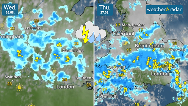
Split weather maps for Wednesday 26.08 and Thursday 27.08 showing showers and thunderstorms spreading across England and Wales, with frequent lightning around London and southeast England on Thursday.
Thunderstorms are likely to break out from Wednesday.

Weather warnings for thunderstorms have been issued for Wednesday and Thursday with a risk of flooding also rising.

Yellow thunderstorm warnings come into effect early Wednesday morning, covering large parts of England from East Anglia through to the West Midlands. Eastern Wales is also included before the warning area expands on Thursday across Wales.

The area of heavy rain moves northwards from the early hours of Wednesday bringing rainfall accumulation of up to 50 mm in parts. Large hailstones are also possible before the first bout of the stormy conditions eases in the evening.

Thursday sees potential for heavier rainfall, potentially up to 75 mm in areas at altitude. More widely rain accumulation of up to 30 mm is likely.

Thundery outbreaks continue along with conditions ripe for more large hail. With much of England and Wales still in drought, parched ground is likely to increase run-off resulting in flash flooding.

The conditions will help alleviate the overall drought, with some 29 million people still under a form of water use restriction, despite presenting immediate flooding issues.

Keep an eye on the conditionsWeatherRadar
Ryan Hathaway
More on the topic
Stormy weather in parts of Europe. Low-pressure system. . . Friday 21 August 2026
Weather radar showing a low-pressure system over the Alps and its track towards the Baltic States. Next to it, a flooded road.
Friday 21 August 2026

Low-pressure system

Stormy weather in parts of Europe
Drought brings flash flood risks. As rain returns. . . Wednesday 19 August 2026
Weather radar map of the UK and Ireland showing widespread showers, with a rain icon and flood warning symbol highlighting the risk from rainfall.
Wednesday 19 August 2026

As rain returns

Drought brings flash flood risks
Flood alerts after heavy showers. Risk in northern England. . . Thursday 20 August 2026
Weather radar map showing persistent heavy rain across northern England around Liverpool, Manchester and Newcastle, with a flood warning symbol highlighting the risk.
Thursday 20 August 2026

Risk in northern England

Flood alerts after heavy showers
All weather news
This might also interest you
Historic Storm Éowyn arrives. On this day.... . . Saturday 24 January 2026
Split image showing a person in a yellow jacket struggling against strong winds and heavy rain on a street at night on the left, and an Irish wind forecast map on the right with red and purple shading, gusts up to 75 mph, and a wind warning icon, divided by a curved white line.
Saturday 24 January 2026

On this day...

Historic Storm Éowyn arrives
Long-term trends need a pinch of salt. 40 °C in July?. . . Tuesday 30 June 2026
Temperature radar of 2022 heatwave where the all-time temperature record in the UK was set. Warning symbol overlain.
Tuesday 30 June 2026

40 °C in July?

Long-term trends need a pinch of salt
Bright and warm conditions take hold. Spring-like outlook. . . Thursday 23 April 2026
Split UK map showing warm temperatures up to 21 degrees in orange on the left and clear sunny conditions with temperatures from 12 to 18 degrees on the right, with sun icons across the country.
Thursday 23 April 2026

Spring-like outlook

Bright and warm conditions take hold
All articles
Weather & Radar

Weather & Radar is also available on

Google Play StoreApp Store

Company

Contact us Privacy Policy Legal info Accessibility statement

Services

Uploader

Socials

facebooktwitteryouTubelinkList