Home
Weather Dublin
WeatherRadar
RainfallRadar
TemperatureRadar
WindRadar
LightningRadar
Weather News
Editor's Pick
Discover the app
Weather widget
Contact us
Apps
    Home / Editor's Pick /

    Wettest week in England for two years

15:23
29 October 2026

Stormy assistance
Wettest week in England for two years

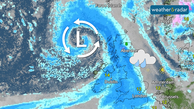
Weather map showing a swirling Atlantic low north-west of Scotland, with blue rain bands across the UK, Ireland, and North Sea and temperatures of 8 to 14°C
Storm Boelo helped fuel the wettest week in England for two years.

Storms Austen and Boelo helped deliver the wettest week in two years, according to provisional data from the Environment Agency.

Between Wednesday, October 21st and Tuesday, October 27th, an average of 55 mm of rainfall accumulated across England. Most notably, the south-west saw 87 mm within the week, marking the wettest reporting week since October 2024.

River flows increased at all but two of the Environment Agency's reporting sites compared to the previous week with rainfall across England as a whole now 111% of the long-term average for October.

Despite the heavy rain, it is not enough to lift drought conditions which still cover much of the country, with a severe drought status still covering swathes of the south-west.

The autumn and winter months provide time for reservoirs and groundwater to replenish, but with three droughts in five years, the period of recovery is increasingly no longer sufficient before the next summer arrives, especially increasingly hotter ones.

For now, a more settled period appears to be on the horizon as high-pressure takes over. Keep an eye on showers via the WeatherRadar, but more sustained rainfall is beginning to move away again.

Ryan Hathaway

More on the topic

Autumn storms sweep across Europe. Boelo and more. . . Monday 26 October 2026
Split image showing a wind forecast with 60 mph near Aberdeen and 50 mph near Dublin, beside a fallen tree blocking a pavement near parked cars.
Monday 26 October 2026

Boelo and more

Autumn storms sweep across Europe
Staying fairly blustery across Ireland. Autumn greetings. . . Thursday 29 October 2026
Wind map showing 35 mph winds near Galway and Cork, 25 mph near Dublin and Belfast, and lighter winds across western Britain, with a windsock symbol.
Thursday 29 October 2026

Autumn greetings

Staying fairly blustery across Ireland
Overnight impacts as Austen hits. Power cuts, travel issues. . . Friday 23 October 2026
Split image showing floodwater surging beneath a railway bridge at night and a wind map with low pressure over the English Channel and 60 mph near Brest.
Friday 23 October 2026

Power cuts, travel issues

Overnight impacts as Austen hits
All weather news

This might also interest you

Flooding, gales, and heavy snow. Storm Chandra. . . Tuesday 27 January 2026
Split image showing aerial flooding in a town with muddy water covering roads on the left, and a rural road on the right blocked by heavy snowfall with vans stopped and a person walking in snow.
Tuesday 27 January 2026

Storm Chandra

Flooding, gales, and heavy snow
A stormy week in the skies above. Your weather - Your shots. . . Sunday 30 August 2026
Split image showing lightning branching beneath dark storm clouds above rooftops on the left and an orange-pink sunset over a calm sea on the right.
Sunday 30 August 2026

Your weather - Your shots

A stormy week in the skies above
Super Typhoon Bavi threatens Taiwan. Up to 1,000 mm of rain. . Weather Videos. Wednesday 8 July 2026
The image shows an intense tropical cyclone over the western Pacific, east of Taiwan and the Philippines. The centre of the system is depicted as a light purple and white vortex with a clearly visible eye, surrounded by a ring of red and orange areas indicating the strongest wind speeds. A white arrow marks the typhoon’s predicted track towards the north-west, in the direction of Taiwan. To the west of the storm lie the Philippines, with the cities of Manila and Cebu; to the north of these lies Taiwan, with Taipei. Further west, the Chinese coast, including Hong Kong, and parts of Vietnam can be seen. The coloured wind map shows predominantly green areas outside the storm’s core, indicating significantly weaker winds. White streamlines illustrate the typhoon’s anti-clockwise circulation in the Northern Hemisphere. The highest wind speeds are concentrated around the eye of the cyclone.
Weather VideosWednesday 8 July 2026

Up to 1,000 mm of rain

Super Typhoon Bavi threatens Taiwan
All articles
Weather & Radar

Weather & Radar is also available on

Google Play StoreApp Store

Company

Contact us Privacy Policy Legal info Accessibility statement

Services

Uploader

Socials

facebooktwitteryouTubelinkList