Home
Weather Dublin
WeatherRadar
RainfallRadar
TemperatureRadar
WindRadar
LightningRadar
Weather News
Editor's Pick
Discover the app
Weather widget
Contact us
Apps
    Home /

    Weekend outlook - Cooler and changeable in parts

12:11
31 July 2026

Weekend outlook
Cooler and changeable in parts

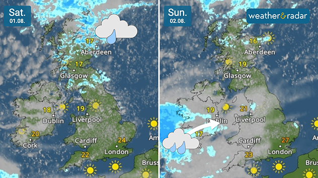
Split satellite weather maps comparing Saturday 01.08 and Sunday 02.08 across the UK and Ireland. Saturday brings widespread showers across Scotland with brighter weather elsewhere, while Sunday sees rain moving into southwest Ireland and scattered showers across western Britain, with sunshine developing in northern Scotland and southern England.
Showers move through parts of the UK and Ireland this weekend.

The coming weekend remains rather cool and changeable across northern and western parts of the UK and Ireland, but still hot and dry in the south-east.

Much like the week behind us, there is little change this weekend. The warmest regions remain in the south-east of England, though cooler than the mid-30s peak on Wednesday.

This means very little help with half of the country in drought, and as of Thursday, all of Wales also officially in drought.

Showers move through parts of Scotland on Saturday, before heavier rainfall pushes in from the Atlantic on Sunday into western Ireland moving eastwards.

Later in the day, this could reach Wales towards midnight, while it remains generally overcast throughout the UK.

The strongest winds are mostly confined to higher altitudes in Scotland this weekend, remaining calm with north-westerly winds bringing a cooler feel.

London

Fr
17
24
Sa
15
25
Su
16
27
Mo
19
28
Tu
19
29
We
20
27
Th
19
28
Fr
19
27
Sa
19
27
Su
18
27
Mo
18
27
Tu
19
28
We
17
26
Th
18
26
Max (°C)
Min (°C)
moreless

Manchester

Fr
8
19
Sa
11
19
Su
10
23
Mo
16
23
Tu
17
25
We
18
23
Th
15
23
Fr
15
22
Sa
15
23
Su
15
24
Mo
16
24
Tu
16
24
We
15
23
Th
14
22
Max (°C)
Min (°C)
moreless

Dublin

Fr
10
20
Sa
10
19
Su
8
19
Mo
15
19
Tu
15
20
We
17
19
Th
13
21
Fr
14
21
Sa
15
22
Su
13
21
Mo
15
23
Tu
13
22
We
13
22
Th
13
21
Max (°C)
Min (°C)
moreless

Edinburgh

Fr
7
17
Sa
10
18
Su
10
20
Mo
11
15
Tu
13
15
We
13
14
Th
13
19
Fr
13
19
Sa
12
20
Su
13
21
Mo
14
21
Tu
14
22
We
14
22
Th
12
20
Max (°C)
Min (°C)
moreless

Cardiff

Fr
9
22
Sa
11
22
Su
11
24
Mo
15
28
Tu
18
24
We
18
24
Th
16
24
Fr
17
25
Sa
17
25
Su
16
24
Mo
17
24
Tu
17
25
We
16
24
Th
16
24
Max (°C)
Min (°C)
moreless
Weather & Radar editorial team
More on the topic
Fourth heatwave of the year. Peaking Wednesday. . . Tuesday 28 July 2026
Temperature map of England and Wales on Wednesday 29.07 showing widespread hot conditions, with temperatures reaching 33°C near Cambridge, 32°C around London, Norwich, and Southend-on-Sea, and a large heat warning symbol highlighting elevated heat risk.
Tuesday 28 July 2026

Peaking Wednesday

Fourth heatwave of the year
Forest fires spread to south-east Europe. Heat and strong winds. . . Thursday 30 July 2026
Split image showing an active wildfire with flames and thick smoke on the left, and a wind forecast map of Greece on the right with gusts of 25–35 mph around the Aegean Sea, alongside a wildfire warning symbol highlighting elevated fire danger.
Thursday 30 July 2026

Heat and strong winds

Forest fires spread to south-east Europe
Icy spells in the Southern Hemisphere. Snow in the Andes. . . Tuesday 28 July 2026
A composite image showing a temperature radar map of South America and a snow-covered town in Chile. The winter cold is bringing heavy snowfall to the Andes and, in some areas, snow down to lower altitudes.
Tuesday 28 July 2026

Snow in the Andes

Icy spells in the Southern Hemisphere
All weather news
This might also interest you
Heat becoming a bigger factor in drought. New study. . . Thursday 23 July 2026
A hand holds dry, dusty earth above a parched field. The ground is cracked and covered with plant debris – a sign of prolonged drought.
Thursday 23 July 2026

New study

Heat becoming a bigger factor in drought
Rain returns to end dry spell in places. Jet stream delivery. . . Thursday 23 July 2026
Split weather graphic showing widespread showers across the UK and Ireland on the left, and a wind forecast map on the right with a windsock icon and gusts of 25 to 35 mph, highlighting breezy conditions across the two countries.
Thursday 23 July 2026

Jet stream delivery

Rain returns to end dry spell in places
Long-term trends need a pinch of salt. Heading over 40°C?. . . Tuesday 21 July 2026
Temperature radar of 2022 heatwave where the all-time temperature record in the UK was set. Warning symbol overlain.
Tuesday 21 July 2026

Heading over 40°C?

Long-term trends need a pinch of salt
All articles
Weather & Radar

Weather & Radar is also available on

Google Play StoreApp Store

Company

Contact us Privacy Policy Legal info Accessibility statement

Services

Uploader

Socials

facebooktwitteryouTubelinkList