Home /

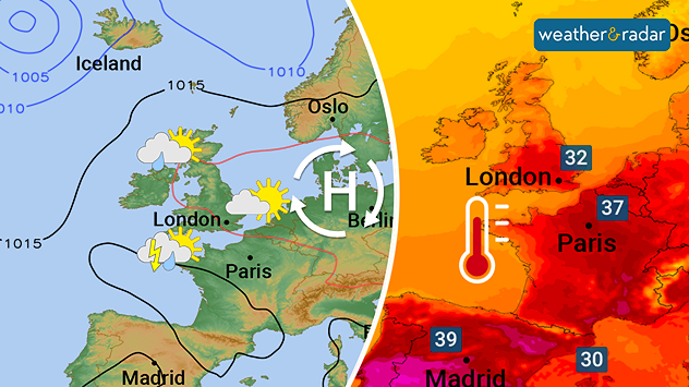
Weather trend: Fine for many, though with some rain in the northwest, hot at times in the south

14:33
11 August 2025

Weather trend
Fine for many, hot at times in the south

High pressure building into central Europe will bring fine and increasingly hot weather for many, though the northwest may remain more unsettled.

The new week starts off with some cloud and showery outbreaks of rain across parts of Ireland, northern England, and Scotland.

Further south and east however, conditions will be very warm and mainly dry on Monday as temperatures could already get close to 30 °C in southeastern England.

The hot continental air may spark off a few showers and thunderstorms Monday night into Tuesday, but the hot air remains across the south and east in particular, where up to 33 °C are possible on Tuesday.

Slightly more changeable weather is then likely around mid-week as winds switch to a more westerly or northwesterly quarter for a while.

Temperatures should fall back a little, at least for a while, before another ridge of high pressure could bring more fine and warm weather for many towards the end of next week.

Western and northern areas should remain slightly cooler and cloudier overall, with some rain or showers at times.

More southern parts of the UK in particular will not see any significant rain away from localised showers and storms.

Looking ahead and generally fine and rather warm weather may continue in the south beyond the middle of the month, while the north and west could see more of a mix of bright spells and some rainier spells.

London

Su
16
29
Mo
18
32
Tu
17
28
We
17
27
Th
19
30
Fr
17
27
Sa
16
26
Su
17
25
Mo
17
26
Tu
15
24
We
16
25
Th
16
24
Fr
15
23
Sa
15
24
Max (°C)
Min (°C)
moreless

Sheffield

Su
15
27
Mo
16
29
Tu
16
31
We
17
27
Th
17
26
Fr
15
27
Sa
14
25
Su
15
23
Mo
15
23
Tu
12
21
We
12
23
Th
13
21
Fr
11
21
Sa
12
21
Max (°C)
Min (°C)
moreless

Glasgow

Su
15
20
Mo
12
25
Tu
12
27
We
14
23
Th
14
21
Fr
11
21
Sa
12
23
Su
12
23
Mo
14
22
Tu
11
21
We
10
20
Th
11
20
Fr
8
20
Sa
9
20
Max (°C)
Min (°C)
moreless

Dublin

Su
16
23
Mo
12
24
Tu
13
26
We
16
23
Th
12
22
Fr
14
22
Sa
14
23
Su
13
23
Mo
13
22
Tu
12
21
We
11
21
Th
12
21
Fr
11
20
Sa
12
21
Max (°C)
Min (°C)
moreless

Belfast

Su
17
22
Mo
12
25
Tu
12
25
We
15
22
Th
12
23
Fr
12
23
Sa
13
22
Su
13
22
Mo
13
22
Tu
13
21
We
12
21
Th
12
21
Fr
11
19
Sa
12
20
Max (°C)
Min (°C)
moreless

Cardiff

Su
13
27
Mo
15
32
Tu
16
26
We
17
24
Th
13
28
Fr
16
29
Sa
17
26
Su
15
24
Mo
16
24
Tu
14
22
We
14
23
Th
14
22
Fr
13
21
Sa
13
21
Max (°C)
Min (°C)
moreless
Lars Lowinski
More on the topic
Friday 1 August 2025

Main impacts in the north

Storm Floris named for Monday
Warning map for strong winds during Storm Floris. Red, level three, warnings across northern Scotland, orange, level two, warnings elsewhere in Scotland and north-west Ireland. Yellow, level one, across Ireland and much of England. Only East Anglia with no warnings. On the right, a wind map showing gusts of up to 55 mph.
Sunday 3 August 2025

Gusts up to 85 mph

Widespread warnings for Storm Floris
Image of a field surrounded by trees. All in full leaf as sunlight shines down from the sky.
Thursday 7 August 2025

Daylight decreases

Up to 2 hour shift in sunset for some
All weather news
This might also interest you
Temperature radar showing the UK and Ireland. A red thermometer is seen next to southern England where highs in the upper-20s can be seen.
Monday 11 August 2025

Breakfast brief

Beginning of the fourth heatwave
Temperature map showing Engand and Wales with a red thermometer. Map is widely red, indicating hot temperatures. Highs of 31 degrees in London, Cardiff, and Birmingham are visible.
Monday 11 August 2025

Heat-health warnings live

Fourth heatwave of the summer
Wind map showing the UK and Ireland showing an area of low pressure to the north-west which brings stronger winds to northern areas of the UK.
Wednesday 6 August 2025

After a brief pause

Fresh low brings renewed winds
All articles
Weather & Radar

www.weatherandradar.ie

facebooktwitteryouTubeContact uslinkList
Privacy Policy | Legal info | Accessibility statement