Home
Weather Dublin
WeatherRadar
RainfallRadar
TemperatureRadar
WindRadar
LightningRadar
Weather News
Editor's Pick
Discover the app
Weather widget
Contact us
Apps
    Home / Editor's Pick /

    Violent thunderstorms mark summer's end - Hail and gusts of wind

12:02
27 August 2026

Hail and gusts of wind
Violent thunderstorms mark summer's end

As the summer draws to a close, the weather is becoming unsettled not just here, but across Europe too.

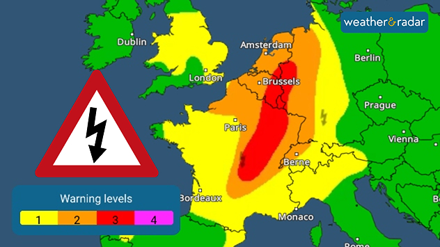
The warm, humid summer air will be swept away across much of Europe by severe thunderstorms. Conditions are set to become particularly extreme on Thursday in the eastern half of France, the Benelux countries and parts of Germany, where large hailstones, heavy downpours, and severe gusts of wind are expected.

Thunderstorm warning map showing level 3 red alerts across eastern France, level 2 orange areas extending into Belgium, and level 1 yellow warnings across surrounding regions.
Widespread thunderstorm warnings cover the region.

On Friday, violent thunderstorms will then also break out in the eastern half of Germany, the Alpine region and the Czech Republic.

After the thunderstorms, the situation will settle down again on Saturday. You can use the WeatherRadar to see when the first thunderstorms are due to reach your area with outbreaks also continuing in parts of the UK.

Click here for the WeatherRadarThunderstorms in sight
Weather & Radar editorial team
More on the topic
Turbulent conditions in southern Europe. Severe thunderstorms. . . Monday 24 August 2026
Weather map shows a risk of severe weather in parts of France and Italy, amongst other places
Monday 24 August 2026

Severe thunderstorms

Turbulent conditions in southern Europe
Slow moving rain brings flooding. More alerts live. . . Thursday 27 August 2026
Weather radar at 11:00 on 27.08 showing widespread heavy rain from Liverpool through the Midlands to eastern England, with an arrow indicating rain moving north.
Thursday 27 August 2026

More alerts live

Slow moving rain brings flooding
Flood alerts after heavy showers. Risk in northern England. . . Thursday 20 August 2026
Weather radar map showing persistent heavy rain across northern England around Liverpool, Manchester and Newcastle, with a flood warning symbol highlighting the risk.
Thursday 20 August 2026

Risk in northern England

Flood alerts after heavy showers
All weather news
This might also interest you
Seasonal warmth between spring thunder. Your weather - Your shots. . . Sunday 19 April 2026
Split image showing coastal sunset with layered lenticular clouds over rooftops and palm trees on the left, and a green valley with river and hills under soft daylight on the right.
Sunday 19 April 2026

Your weather - Your shots

Seasonal warmth between spring thunder
A frozen start to the weekend. Icy conditions. . . Friday 13 February 2026
UK temperature map dated 14.02 showing widespread subzero values in blue shading, with readings such as −4 in Glasgow, −3 in Dublin, and −2 in London, alongside a blue thermometer icon.
Friday 13 February 2026

Icy conditions

A frozen start to the weekend
Historic Storm Éowyn arrives. On this day.... . . Saturday 24 January 2026
Split image showing a person in a yellow jacket struggling against strong winds and heavy rain on a street at night on the left, and an Irish wind forecast map on the right with red and purple shading, gusts up to 75 mph, and a wind warning icon, divided by a curved white line.
Saturday 24 January 2026

On this day...

Historic Storm Éowyn arrives
All articles
Weather & Radar

Weather & Radar is also available on

Google Play StoreApp Store

Company

Contact us Privacy Policy Legal info Accessibility statement

Services

Uploader

Socials

facebooktwitteryouTubelinkList