Home
Weather Dublin
WeatherRadar
RainfallRadar
TemperatureRadar
WindRadar
LightningRadar
Weather News
Editor's Pick
Discover the app
Weather widget
Contact us
Apps
    Home / Editor's Pick /

    Severe storms expected in the Mediterranean - Risk of flooding

10:00
13 October 2026

Risk of flooding
Severe storms expected in the Med

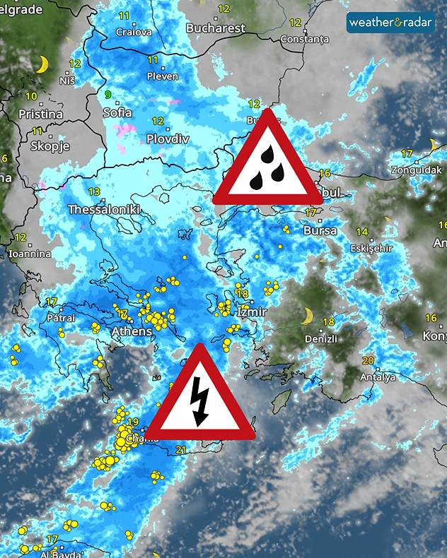
Turbulent days lie ahead for Greece and Turkey. A low-pressure system over the eastern Mediterranean is causing a significant risk of severe weather.

As early as Tuesday, severe thunderstorms accompanied by heavy rain and gusts of wind will develop from Crete and the Peloponnese, passing through Athens and reaching as far as western Turkey.

The WeatherRadar forecast shows the storms over the Aegean Sea.

The situation is also set to become particularly dangerous, with a risk of flooding, in the region around Istanbul. More than 250 mm of rain could fall there by the weekend. In the Aegean Sea and along the coasts, conditions will also become very stormy, with gusts of up to 65 mph.

On Wednesday, the area of bad weather will spread. The Turkish Mediterranean coast and Cyprus will be affected.

Follow the severe weather liveWeatherRadar
Weather & Radar editorial team
More on the topic
Gales build again for Ireland. Turbulent week ahead. . . Monday 12 October 2026
Wind map showing 40 mph winds near Galway, 30 mph near Cork, 25 mph near Dublin and 23 mph near Belfast, with a windsock symbol.
Monday 12 October 2026

Turbulent week ahead

Gales build again for Ireland
Hurricane threatens the US coast. First storm of the season. . . Thursday 8 October 2026
The WindRadar shows a powerful hurricane off the US Gulf Coast. Wind speeds of 75 miles per hour are being recorded around the centre of the storm.
Thursday 8 October 2026

First storm of the season

Hurricane threatens the US coast
Tornadoes rage across Sicily. Cars sent flying. . Weather Videos. Saturday 10 October 2026
A split image showing a tornado off the coast of Sicily on the left-hand side. A dark cloud funnel extends down to the ground or the water’s surface; houses and palm trees can be seen in the foreground. On the right, a weather map near Marsala shows heavy rainfall in pink and blue, numerous flashes of lightning as yellow dots, and a white whirlwind symbol.
Weather VideosSaturday 10 October 2026

Cars sent flying

Tornadoes rage across Sicily
All weather news
This might also interest you
Historic Storm Éowyn arrives. On this day.... . . Saturday 24 January 2026
Split image showing a person in a yellow jacket struggling against strong winds and heavy rain on a street at night on the left, and an Irish wind forecast map on the right with red and purple shading, gusts up to 75 mph, and a wind warning icon, divided by a curved white line.
Saturday 24 January 2026

On this day...

Historic Storm Éowyn arrives
Flooding, gales, and heavy snow. Storm Chandra. . . Tuesday 27 January 2026
Split image showing aerial flooding in a town with muddy water covering roads on the left, and a rural road on the right blocked by heavy snowfall with vans stopped and a person walking in snow.
Tuesday 27 January 2026

Storm Chandra

Flooding, gales, and heavy snow
Storm Chandra makes impact. Severe gales & heavy rain. . . Tuesday 27 January 2026
Split image showing strong winds over the UK on a forecast map and widespread rain and snow on a weather radar map.
Tuesday 27 January 2026

Severe gales & heavy rain

Storm Chandra makes impact
All articles
Weather & Radar

Weather & Radar is also available on

Google Play StoreApp Store

Company

Contact us Privacy Policy Legal info Accessibility statement

Services

Uploader

Socials

facebooktwitteryouTubelinkList