Home
Weather Dublin
WeatherRadar
RainfallRadar
TemperatureRadar
WindRadar
LightningRadar
Weather News
Editor's Pick
Discover the app
Weather widget
Contact us
Apps
    Home / Editor's Pick /

    Rain remains scarce - Poor harvest expected after drought

15:22
6 August 2026

Rain remains scarce
Poor harvest expected after drought

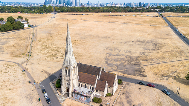
Aerial view of a church surrounded by parched yellow-brown fields with a city skyline in the distance, highlighting widespread drought and dry grass under clear summer skies.
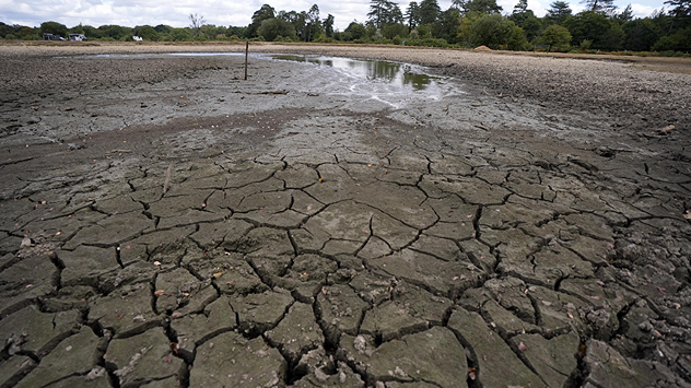
Cracked mud covering the floor of a dried-up pond with a small pool of remaining water, exposed shoreline, and trees in the background, illustrating severe drought conditions.
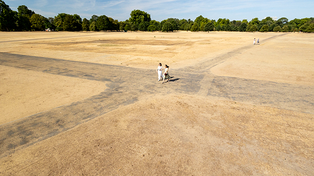
Aerial view of a large park with dry yellow-brown grass, intersecting footpaths, and a few people walking across the parched landscape beneath clear summer skies.
1/4
Blackheath's All Saints' Church stands amid scorched fields in south-east London. - © picture alliance

England and Wales' drought situation continues to worsen with rain still nowhere to be seen.

After the driest July on record in both countries, the non-profit Energy & Climate Intelligence Unit say this year's harvest is set to be the worst since records began in 1984.

Oat, wheat, and spring barley supplies are expected to be below the ten-year average, if current figures become reality it would surpass 2020 as the worst harvest ever. Even if yields are slightly better, it would still result in four of the five worse harvests taking place over the past decade.

The situation is similar across Europe with yields expected to fall, potentially leading to shortages and price increases of some foods.

These warnings come ahead of the fifth heatwave of the year with temperatures passing 30°C again next week.

Ahead of the heat's return, yellow heat-health alerts have been issued for all parts of England aside from the north-west and north-east.

Extreme heat in eastern Europeread more

Ryan Hathaway

More on the topic

Blocking high brings anticyclonic gloom. Overcast days. . . Tuesday 3 November 2026
Split weather maps showing widespread cloud across the UK and Ireland alongside a high-pressure system centred over Britain, with isobars near 1035 hPa.
Tuesday 3 November 2026

Overcast days

Blocking high brings anticyclonic gloom
Wettest week in England for two years. Stormy assistance. . . Thursday 29 October 2026
Weather map for Saturday 24.10 showing a swirling Atlantic low, Storm Boelo, west of Scotland and widespread blue rain bands across the UK, Ireland and northern France.
Thursday 29 October 2026

Stormy assistance

Wettest week in England for two years
From late summer to storm warnings. Contrasts in Europe. . Weather Videos. Thursday 29 October 2026
Split image: On the left, the temperature radar for Spain and Portugal shows readings of up to 28 degrees. On the right, waves crash onto a flooded beach dotted with parasols and sun loungers amid stormy weather.
Weather VideosThursday 29 October 2026

Contrasts in Europe

From late summer to storm warnings
All weather news

This might also interest you

New records for England and Wales. Broken again tomorrow?. . . Thursday 25 June 2026
Temperature map of southwest Britain on 25.06 showing extreme heat across southern Wales and southwest England, with Bute Park in Cardiff highlighted at 34.2°C and Yeovilton at 36.4°C amid widespread deep red heat zones.
Thursday 25 June 2026

Broken again tomorrow?

New records for England and Wales
Seasonal warmth between spring thunder. Your weather - Your shots. . . Sunday 19 April 2026
Split image showing coastal sunset with layered lenticular clouds over rooftops and palm trees on the left, and a green valley with river and hills under soft daylight on the right.
Sunday 19 April 2026

Your weather - Your shots

Seasonal warmth between spring thunder
Super Typhoon Bavi threatens Taiwan. Up to 1,000 mm of rain. . Weather Videos. Wednesday 8 July 2026
The image shows an intense tropical cyclone over the western Pacific, east of Taiwan and the Philippines. The centre of the system is depicted as a light purple and white vortex with a clearly visible eye, surrounded by a ring of red and orange areas indicating the strongest wind speeds. A white arrow marks the typhoon’s predicted track towards the north-west, in the direction of Taiwan. To the west of the storm lie the Philippines, with the cities of Manila and Cebu; to the north of these lies Taiwan, with Taipei. Further west, the Chinese coast, including Hong Kong, and parts of Vietnam can be seen. The coloured wind map shows predominantly green areas outside the storm’s core, indicating significantly weaker winds. White streamlines illustrate the typhoon’s anti-clockwise circulation in the Northern Hemisphere. The highest wind speeds are concentrated around the eye of the cyclone.
Weather VideosWednesday 8 July 2026

Up to 1,000 mm of rain

Super Typhoon Bavi threatens Taiwan
All articles
Weather & Radar

Weather & Radar is also available on

Google Play StoreApp Store

Company

Contact us Privacy Policy Legal info Accessibility statement

Services

Uploader

Socials

facebooktwitteryouTubelinkList