Home
Weather Dublin
WeatherRadar
RainfallRadar
TemperatureRadar
WindRadar
LightningRadar
Weather News
Editor's Pick
Discover the app
Weather widget
Contact us
Apps
    Home / Editor's Pick /

    Photos from across Europe - Night sky in the spotlight

09:00
14 August 2025

Photos from across Europe
Night sky in the spotlight

Dark sky full of stars. Several shooting stars fly in different directions – typical of a meteor shower.
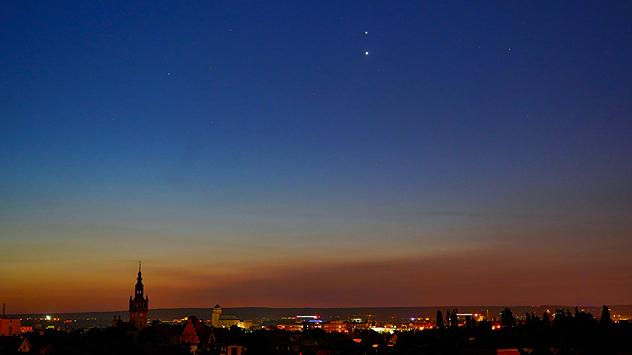
Evening sky over a city with churches and lights. Two bright planets shine in the darkening sky.
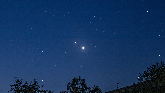
Black sky with two bright points of light close together – Jupiter and Venus.
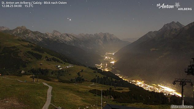
View of an illuminated mountain region at night. Above the mountains, a clear starry sky with visible constellations.
Blue night sky with many stars. Two strikingly bright planets shine above the outlines of trees and rooftops.
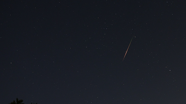
Dark night sky with lots of stars. A bright shooting star shoots diagonally from the top right to the bottom left.
An orange full moon rises above a dark tree. In the background, gentle hills in the twilight.
1/7
Bright shooting stars from the Perseids were snapped over the Czech Republic in this composite of 800 pictures. - © Miloslav Rohacek

Don't miss out on a collection of remarkable astronomical sights over head right now.

The night and morning sky are bringing awe-inspiring views: the Perseids are shining in all their glory, while Jupiter and Venus are shining close together in the firmament. Impressive images of this celestial spectacle are reaching us from many regions of Europe.

The Perseids will be visible until around August 24th. With the waning moon and clear skies, conditions are now even better than they were at their peak a few days ago.

In our astro info section, you will find everything you need to plan your stargazing, including moon phases and current sunrise and sunset times.

Annika Jacob
Ryan Hathaway
More on the topic
Severe weather risk in holiday spots. Hail and heavy rain. . . Wednesday 19 August 2026
Split weather graphic showing intense thunderstorms and widespread lightning across northern Italy and Switzerland on the left, with severe warning zones from yellow to red around Milan and the southern Alps on the right.
Wednesday 19 August 2026

Hail and heavy rain

Severe weather risk in holiday spots
Flood alerts after heavy showers. Risk in northern England. . . Thursday 20 August 2026
Weather radar map showing persistent heavy rain across northern England around Liverpool, Manchester and Newcastle, with a flood warning symbol highlighting the risk.
Thursday 20 August 2026

Risk in northern England

Flood alerts after heavy showers
Stormy weather in parts of Europe. Low-pressure system. . . Friday 21 August 2026
Weather radar showing a low-pressure system over the Alps and its track towards the Baltic States. Next to it, a flooded road.
Friday 21 August 2026

Low-pressure system

Stormy weather in parts of Europe
All weather news
This might also interest you
Super Typhoon Bavi threatens Taiwan. Up to 1,000 mm of rain. . Weather Videos. Wednesday 8 July 2026
The image shows an intense tropical cyclone over the western Pacific, east of Taiwan and the Philippines. The centre of the system is depicted as a light purple and white vortex with a clearly visible eye, surrounded by a ring of red and orange areas indicating the strongest wind speeds. A white arrow marks the typhoon’s predicted track towards the north-west, in the direction of Taiwan. To the west of the storm lie the Philippines, with the cities of Manila and Cebu; to the north of these lies Taiwan, with Taipei. Further west, the Chinese coast, including Hong Kong, and parts of Vietnam can be seen. The coloured wind map shows predominantly green areas outside the storm’s core, indicating significantly weaker winds. White streamlines illustrate the typhoon’s anti-clockwise circulation in the Northern Hemisphere. The highest wind speeds are concentrated around the eye of the cyclone.
Weather VideosWednesday 8 July 2026

Up to 1,000 mm of rain

Super Typhoon Bavi threatens Taiwan
Bright and warm conditions take hold. Spring-like outlook. . . Thursday 23 April 2026
Split UK map showing warm temperatures up to 21 degrees in orange on the left and clear sunny conditions with temperatures from 12 to 18 degrees on the right, with sun icons across the country.
Thursday 23 April 2026

Spring-like outlook

Bright and warm conditions take hold
Historic Storm Éowyn arrives. On this day.... . . Saturday 24 January 2026
Split image showing a person in a yellow jacket struggling against strong winds and heavy rain on a street at night on the left, and an Irish wind forecast map on the right with red and purple shading, gusts up to 75 mph, and a wind warning icon, divided by a curved white line.
Saturday 24 January 2026

On this day...

Historic Storm Éowyn arrives
All articles
Weather & Radar

Weather & Radar is also available on

Google Play StoreApp Store

Company

Contact us Privacy Policy Legal info Accessibility statement

Services

Uploader

Socials

facebooktwitteryouTubelinkList