Home
Weather Dublin
WeatherRadar
RainfallRadar
TemperatureRadar
WindRadar
LightningRadar
Weather News
Editor's Pick
Discover the app
Weather widget
Contact us
Apps
    Home / Editor's Pick /

    Hail and heavy rain - Severe weather risk in holiday spots

12:00
19 August 2026

Hail and heavy rain
Severe weather risk in holiday spots

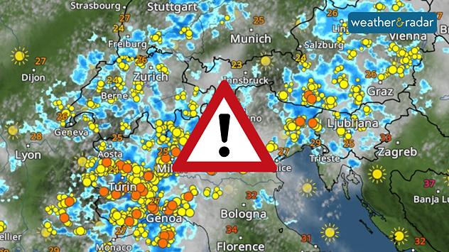
Holidaymakers take note: Severe thunderstorms are forecast for tomorrow from northern Italy as far as the Alps. Outbreaks were already forming Wednesday morning in the Western Alps.

By the evening, the focus will have shifted to the northern Adriatic and Austria. The thunderstorms may, in some places, bring large hailstones, torrential rain, and gale-force gusts. Even isolated tornadoes cannot be ruled out.

Important to know

Not everyone is directly affected by a thunderstorm. In one place, it may only rain lightly or remain dry, whilst in another place the storm rages.

In any case, you should keep a close eye on the sky and the WeatherRadar if you're in the area.

WeatherRadar: There’ll be some heavy localised storms on Thursday.
Always keep an eye on the situationLive WeatherRadar
Weather & Radar editorial team
More on the topic
Hurricane POLO remains dangerous. Many storms in the Pacific. . . Thursday 24 September 2026
Thursday 24 September 2026

Many storms in the Pacific

Hurricane POLO remains dangerous
Weather contrasts over Europe. Low versus high. . . Tuesday 29 September 2026
A powerful low-pressure system off Iceland is clashing with a stable high-pressure system over Scandinavia. Central Europe lies between them.
Tuesday 29 September 2026

Low versus high

Weather contrasts over Europe
First taste of winter in the Alps. White mountain peaks. . Weather Videos. Friday 25 September 2026
Winter scenery in the Alps along the Großglockner High Alpine Road
Weather VideosFriday 25 September 2026

White mountain peaks

First taste of winter in the Alps
All weather news
This might also interest you
Super Typhoon Bavi threatens Taiwan. Up to 1,000 mm of rain. . Weather Videos. Wednesday 8 July 2026
The image shows an intense tropical cyclone over the western Pacific, east of Taiwan and the Philippines. The centre of the system is depicted as a light purple and white vortex with a clearly visible eye, surrounded by a ring of red and orange areas indicating the strongest wind speeds. A white arrow marks the typhoon’s predicted track towards the north-west, in the direction of Taiwan. To the west of the storm lie the Philippines, with the cities of Manila and Cebu; to the north of these lies Taiwan, with Taipei. Further west, the Chinese coast, including Hong Kong, and parts of Vietnam can be seen. The coloured wind map shows predominantly green areas outside the storm’s core, indicating significantly weaker winds. White streamlines illustrate the typhoon’s anti-clockwise circulation in the Northern Hemisphere. The highest wind speeds are concentrated around the eye of the cyclone.
Weather VideosWednesday 8 July 2026

Up to 1,000 mm of rain

Super Typhoon Bavi threatens Taiwan
Historic Storm Éowyn arrives. On this day.... . . Saturday 24 January 2026
Split image showing a person in a yellow jacket struggling against strong winds and heavy rain on a street at night on the left, and an Irish wind forecast map on the right with red and purple shading, gusts up to 75 mph, and a wind warning icon, divided by a curved white line.
Saturday 24 January 2026

On this day...

Historic Storm Éowyn arrives
Seasonal warmth between spring thunder. Your weather - Your shots. . . Sunday 19 April 2026
Split image showing coastal sunset with layered lenticular clouds over rooftops and palm trees on the left, and a green valley with river and hills under soft daylight on the right.
Sunday 19 April 2026

Your weather - Your shots

Seasonal warmth between spring thunder
All articles
Weather & Radar

Weather & Radar is also available on

Google Play StoreApp Store

Company

Contact us Privacy Policy Legal info Accessibility statement

Services

Uploader

Socials

facebooktwitteryouTubelinkList