Home
Weather Dublin
WeatherRadar
RainfallRadar
TemperatureRadar
WindRadar
LightningRadar
Weather News
Editor's Pick
Discover the app
Weather widget
Contact us
Apps
    Home / Editor's Pick /

    Latest heatwave - UV levels peak with the heat today

08:34
29 July 2026

Latest heatwave
UV levels peak with the heat today

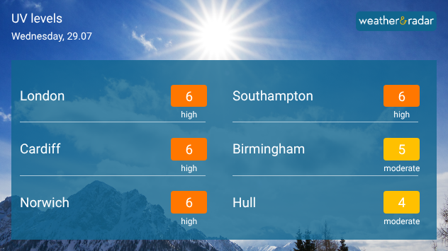
UV level forecast for Wednesday 29.07 showing high UV index varlues of 6 in London, Cardiff, Norwich, and Southampton, with moderate levels of 5 in Birmingham and 4 in Hull beaneath bright sunshine.
High to moderate UV levels across parts of England and Wales.

The latest heatwave in parts of England and Wales sees its peak temperatures today, and as the heat rises, so do the UV levels.

Temperatures will hit the low-30s widely in central to eastern England on Wednesday, perhaps as high as 35°C locally.

With these temperatures, UV levels are also at high to moderate levels across the UK.

The UV risk in Ireland is not comparable, with the whole country seeing low levels between 0 to 2 (in Galway and Cork) today.

When the UV intensifies, it's important to regularly reapply sun cream, try and seek shade during the peak sunlight hours, and stay hydrated in the heat.

You can find the UV feature on the app's homescreen, and keep an eye on the heat on the TemperatureRadar.

Ryan Hathaway

More on the topic

Storm Austen approaches. What to expect tonight. . Weather Videos. Thursday 22 October 2026
Split image showing a wind map with 65 mph near Brest and a swirling storm south of England, beside a man wearing glasses and holding a microphone.
Weather VideosThursday 22 October 2026

What to expect tonight

Storm Austen approaches
Preparing for the storms. What to do now. . . Thursday 22 October 2026
Split image showing Storm Austen winds up to 65 mph near Brest and 55 mph near Plymouth, alongside fallen tree branches on a cordoned-off park path.
Thursday 22 October 2026

What to do now

Preparing for the storms
Shooting stars from the Orionids peak. Mixed visibility overnight. . . Wednesday 21 October 2026
Split image showing a bright green meteor streaking across a starry night sky beside a UK weather map with rain over Scotland and southern England.
Wednesday 21 October 2026

Mixed visibility overnight

Shooting stars from the Orionids peak
All weather news

This might also interest you

Storm Chandra makes impact. Severe gales & heavy rain. . . Tuesday 27 January 2026
Split image showing strong winds over the UK on a forecast map and widespread rain and snow on a weather radar map.
Tuesday 27 January 2026

Severe gales & heavy rain

Storm Chandra makes impact
Seasonal warmth between spring thunder. Your weather - Your shots. . . Sunday 19 April 2026
Split image showing coastal sunset with layered lenticular clouds over rooftops and palm trees on the left, and a green valley with river and hills under soft daylight on the right.
Sunday 19 April 2026

Your weather - Your shots

Seasonal warmth between spring thunder
Bright and warm conditions take hold. Spring-like outlook. . . Thursday 23 April 2026
Split UK map showing warm temperatures up to 21 degrees in orange on the left and clear sunny conditions with temperatures from 12 to 18 degrees on the right, with sun icons across the country.
Thursday 23 April 2026

Spring-like outlook

Bright and warm conditions take hold
All articles
Weather & Radar

Weather & Radar is also available on

Google Play StoreApp Store

Company

Contact us Privacy Policy Legal info Accessibility statement

Services

Uploader

Socials

facebooktwitteryouTubelinkList