Home
Weather Dublin
WeatherRadar
RainfallRadar
TemperatureRadar
WindRadar
LightningRadar
Weather News
Editor's Pick
Discover the app
Weather widget
Contact us
Apps
    Home / Editor's Pick /

    Mixed visibility overnight as shooting stars from the Orionids peak

17:00
21 October 2026

Mixed visibility overnight
Shooting stars from the Orionids peak

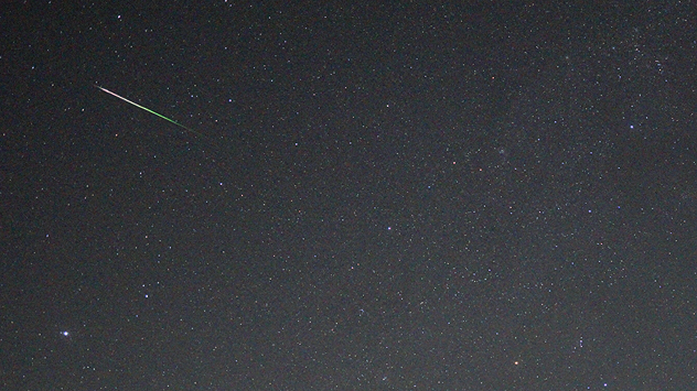
Bright meteor with a white and green trail streaks diagonally across a dark, star-filled night sky.
A shooting star from the Orionids pictured over Harzgerode, Germany this week. - © Torsten Brehme

The annual Orionid Meteor Shower peaks overnight, and despite the unsettled weather, there are good viewing conditions on offer in much of the UK and Ireland.

Produced by debris left behind by the famous Halley's Comet, skywatchers have a chance of seeing up to 20 shooting stars an hour from the Orionids.

The overnight peak of activity is expected between midnight and dawn, though they will be easier to spot after the moon sets around 01:30 am.

Despite the unpleasant weather, a valley of better visibility stretches across England into south-west Scotland, while much of Ireland and Northern Ireland will have a good chance of seeing the display.

As with any astronomical display, the best chance to spot a shooting star will lay away from cities and their light pollution. No telescope is needed when the meteors begin to appear, but be sure to keep an eye on the rain via the WeatherRadar.

If you do miss out because of the weather, the Orionids will still be on display until November 7th, with lowering frequency until next year's arrival.

Ryan Hathaway

More on the topic

Severe flooding in the south of France. Roads become rivers. . Weather Videos. Wednesday 21 October 2026
Weather radar shows heavy rainfall over southern France, northern Italy, Corsica and Sardinia. A warning symbol indicates a risk of flooding.
Weather VideosWednesday 21 October 2026

Roads become rivers

Severe flooding in the south of France
High-pressure shifts the weather pattern. Change in Europe. . . Friday 16 October 2026
Split European weather maps showing low pressure near Norway shifting to high pressure over Scandinavia, with arrows indicating changing airflow patterns.
Friday 16 October 2026

Change in Europe

High-pressure shifts the weather pattern
Autumn colours and aurora displays. Your weather - Your shots. . . Sunday 18 October 2026
Split image showing an orange coastal sunset over a winding tidal stream and jagged rocks beside purple northern lights above houses at night.
Sunday 18 October 2026

Your weather - Your shots

Autumn colours and aurora displays
All weather news

This might also interest you

Storm Chandra makes impact. Severe gales & heavy rain. . . Tuesday 27 January 2026
Split image showing strong winds over the UK on a forecast map and widespread rain and snow on a weather radar map.
Tuesday 27 January 2026

Severe gales & heavy rain

Storm Chandra makes impact
A frozen start to the weekend. Icy conditions. . . Friday 13 February 2026
UK temperature map dated 14.02 showing widespread subzero values in blue shading, with readings such as −4 in Glasgow, −3 in Dublin, and −2 in London, alongside a blue thermometer icon.
Friday 13 February 2026

Icy conditions

A frozen start to the weekend
Super Typhoon Bavi threatens Taiwan. Up to 1,000 mm of rain. . Weather Videos. Wednesday 8 July 2026
The image shows an intense tropical cyclone over the western Pacific, east of Taiwan and the Philippines. The centre of the system is depicted as a light purple and white vortex with a clearly visible eye, surrounded by a ring of red and orange areas indicating the strongest wind speeds. A white arrow marks the typhoon’s predicted track towards the north-west, in the direction of Taiwan. To the west of the storm lie the Philippines, with the cities of Manila and Cebu; to the north of these lies Taiwan, with Taipei. Further west, the Chinese coast, including Hong Kong, and parts of Vietnam can be seen. The coloured wind map shows predominantly green areas outside the storm’s core, indicating significantly weaker winds. White streamlines illustrate the typhoon’s anti-clockwise circulation in the Northern Hemisphere. The highest wind speeds are concentrated around the eye of the cyclone.
Weather VideosWednesday 8 July 2026

Up to 1,000 mm of rain

Super Typhoon Bavi threatens Taiwan
All articles
Weather & Radar

Weather & Radar is also available on

Google Play StoreApp Store

Company

Contact us Privacy Policy Legal info Accessibility statement

Services

Uploader

Socials

facebooktwitteryouTubelinkList