Home
Weather Dublin
WeatherRadar
RainfallRadar
TemperatureRadar
WindRadar
LightningRadar
Weather News
Editor's Pick
Discover the app
Weather widget
Contact us
Apps
    Home / Editor's Pick /

    Heavy rain and storms - Severe weather on the Canary Islands

11:05
18 March 2026

Heavy rain and storms
Severe weather on the Canary Islands

It’s not something you see every day: a powerful Atlantic low-pressure system is bringing unusually wet and stormy weather to the Canary Islands.

There is a risk of torrential rain, gale-force winds and dangerous sea conditions.

Did you know?

The Canary Islands are renowned for their mild, stable trade wind climate all year round, with plenty of sunshine and only rare extreme weather events.

Over the next few days, heavy showers and thunderstorms will continue to sweep across the archipelago. By the weekend, some areas will have received over 100 mm of rain per square metre, with significantly higher amounts in places.

The western coasts of La Palma and Tenerife are particularly affected, with rainfall of up to 200 mm possible there.

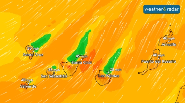
WindRadar: On Thursday, there will be a strong to gale-force south-westerly wind.

There will also be strong winds, with gusts expected particularly on Thursday and Friday. Consequently, dangerous, high waves are set to hit the coasts. The weather will remain unpleasant on the islands over the weekend.

The weekend remains turbulentCanary Islands WeatherRadar
Tommy Kühnlein
More on the topic
Forest fires spread to south-east Europe. Heat and strong winds. . . Thursday 30 July 2026
Split image showing an active wildfire with flames and thick smoke on the left, and a wind forecast map of Greece on the right with gusts of 25–35 mph around the Aegean Sea, alongside a wildfire warning symbol highlighting elevated fire danger.
Thursday 30 July 2026

Heat and strong winds

Forest fires spread to south-east Europe
Fourth heatwave of the year. Peaking Wednesday. . . Tuesday 28 July 2026
Temperature map of England and Wales on Wednesday 29.07 showing widespread hot conditions, with temperatures reaching 33°C near Cambridge, 32°C around London, Norwich, and Southend-on-Sea, and a large heat warning symbol highlighting elevated heat risk.
Tuesday 28 July 2026

Peaking Wednesday

Fourth heatwave of the year
Europe’s seas are unusually warm. Up to 30 degrees. . . Friday 31 July 2026
Friday 31 July 2026

Up to 30 degrees

Europe’s seas are unusually warm
All weather news
This might also interest you
Storm Chandra makes impact. Severe gales & heavy rain. . . Tuesday 27 January 2026
Split image showing strong winds over the UK on a forecast map and widespread rain and snow on a weather radar map.
Tuesday 27 January 2026

Severe gales & heavy rain

Storm Chandra makes impact
Historic Storm Éowyn arrives. On this day.... . . Saturday 24 January 2026
Split image showing a person in a yellow jacket struggling against strong winds and heavy rain on a street at night on the left, and an Irish wind forecast map on the right with red and purple shading, gusts up to 75 mph, and a wind warning icon, divided by a curved white line.
Saturday 24 January 2026

On this day...

Historic Storm Éowyn arrives
Long-term trends need a pinch of salt. 40 °C in July?. . . Tuesday 30 June 2026
Temperature radar of 2022 heatwave where the all-time temperature record in the UK was set. Warning symbol overlain.
Tuesday 30 June 2026

40 °C in July?

Long-term trends need a pinch of salt
All articles
Weather & Radar

Weather & Radar is also available on

Google Play StoreApp Store

Company

Contact us Privacy Policy Legal info Accessibility statement

Services

Uploader

Socials

facebooktwitteryouTubelinkList