Home
Weather Dublin
WeatherRadar
RainfallRadar
TemperatureRadar
WindRadar
LightningRadar
Weather News
Editor's Pick
Discover the app
Weather widget
Contact us
Apps
    Home / Editor's Pick /

    Hail and storm damage - Violent storms impacting northern Italy

12:00
16 July 2026

Hail and storm damage
Violent storms impacting northern Italy

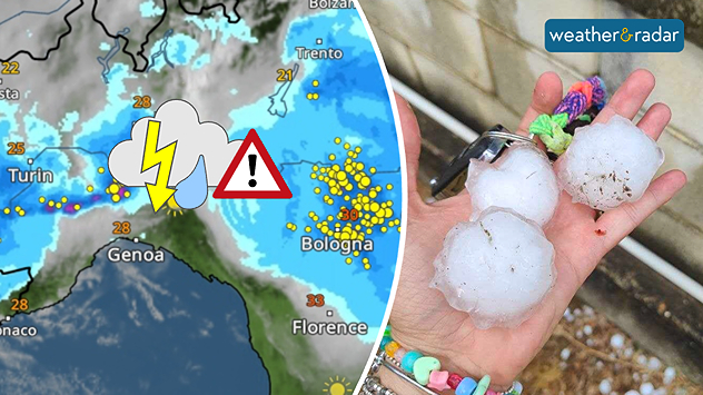
Severe thunderstorms swept through northern Italy on Wednesday afternoon. So-called supercells moved from Piedmont through Emilia-Romagna to Friuli-Venezia Giulia.

Did you know?

Supercells are among the most dangerous thunderstorms. They often bring large hailstones, torrential rain, and severe gusts of wind. The risk of tornadoes is also higher than with other types of thunderstorm.

In Piedmont, hailstones the size of golf balls fell in some places; near Turin, hail measuring up to 9 centimetres were reported. Around Bologna, gale-force winds of around 75 mph uprooted trees and damaged roofs, causing widespread disruption on the roads.

The WeatherRadar shows yesterday’s storms, which brought large to very large hailstones in some areas.

There is a risk of further severe localised thunderstorms in Italy today and tomorrow, particularly near the borders with France, Switzerland, and Austria. Keep an eye on the situation with the WeatherRadar.

Track thunderstorms liveGlobal WeatherRadar

Weather & Radar editorial team
More on the topic
More comfortable night's sleep. Overnight low drops. . . Wednesday 5 August 2026
Morning temperature map of the UK and Ireland showing cool conditions, with temperatures ranging from 7°C in South Wales to 13°C in southeast England. Ireland records 9–12°C, while much of England and Wales is between 8°C and 10°C. A blue thermometer icon highlights the cooler weather.
Wednesday 5 August 2026

Overnight low drops

More comfortable night's sleep
Cooler nights on the horizon. For parts of Europe. . . Thursday 6 August 2026
Temperature Radar showing the night-time lows in Central Europe. Cooler air is reaching the west and north in particular, whilst the south-east remains significantly warmer.
Thursday 6 August 2026

For parts of Europe

Cooler nights on the horizon
Stronger winds make a return. Low pressure influence. . . Tuesday 4 August 2026
Wind forecast map of the UK and Ireland showing a low-pressure system north of Scotland, a windsock icon highlighting blustery conditions, and widespread winds of 30–40 mph across the British Isles, with the strongest winds around Ireland and northern Britain.
Tuesday 4 August 2026

Low pressure influence

Stronger winds make a return
All weather news
This might also interest you
Turbulent weather in the Canary Islands. Storm and rain. . . Friday 12 December 2025
Weather graphic showing rain and wind fields over the Canary Islands and a central warning symbol.
Friday 12 December 2025

Storm and rain

Turbulent weather in the Canary Islands
Long-term trends need a pinch of salt. 40 °C in July?. . . Tuesday 30 June 2026
Temperature radar of 2022 heatwave where the all-time temperature record in the UK was set. Warning symbol overlain.
Tuesday 30 June 2026

40 °C in July?

Long-term trends need a pinch of salt
Bright and warm conditions take hold. Spring-like outlook. . . Thursday 23 April 2026
Split UK map showing warm temperatures up to 21 degrees in orange on the left and clear sunny conditions with temperatures from 12 to 18 degrees on the right, with sun icons across the country.
Thursday 23 April 2026

Spring-like outlook

Bright and warm conditions take hold
All articles
Weather & Radar

Weather & Radar is also available on

Google Play StoreApp Store

Company

Contact us Privacy Policy Legal info Accessibility statement

Services

Uploader

Socials

facebooktwitteryouTubelinkList