Home
Weather Dublin
WeatherRadar
RainfallRadar
TemperatureRadar
WindRadar
LightningRadar
Weather News
Editor's Pick
Discover the app
Weather widget
Contact us
Apps
    Home / Editor's Pick /

    El Niño is gaining momentum – record temperatures are possible

17:00
6 May 2026

Temperature records?
El Niño is gaining momentum

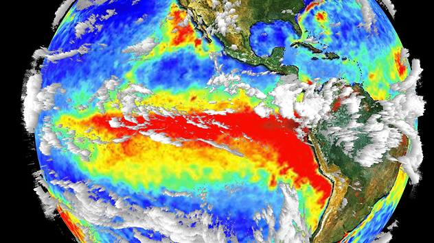
The image shows the central Pacific in a computer model. A striking feature is the ocean coloured red, which indicates very warm seawater.
Exceptionally warm sea water in the equatorial Pacific is a characteristic feature of the El Niño climate phenomenon. - © dpa

An exceptionally strong El Niño may be on the horizon in the Pacific. At the same time, sea temperatures in many parts of the world are above the long-term average.

It is precisely this combination that is considered particularly concerning.

The El Niño climate phenomenon has an additional warming effect on the atmosphere and oceans. Experts are therefore warning not so much about El Niño itself, but rather about its interaction with oceans that are already exceptionally warm, and the long-term warming trend.

The presence of a strong El Niño us likely to lead to droughts, heavy rainfall, and heatwaves becoming more severe in certain regions than in the past.

The Pacific region is particularly affected by these typical impacts. Western South America faces the threat of heavy rainfall, whilst in Australia, Indonesia and parts of Brazil the risk of drought and forest fires is increasing.

The Atlantic also plays an important role in this. El Niño usually weakens the conditions for powerful hurricanes there.

More concerning, however, is the potential trend in global temperatures. New heat records in the coming months cannot be ruled out. How badly Europe will be affected, however, remains to be to be seen.

Current temperatures worldwideTemperatureRadar

Weather & Radar editorial team
More on the topic
Low delivers days of gusty conditions. Into the weekend. . . Thursday 17 September 2026
Wind map showing low pressure near the Faroe Islands, with winds reaching 35 mph around Aberdeen and Dublin and stronger Atlantic winds west of the UK.
Thursday 17 September 2026

Into the weekend

Low delivers days of gusty conditions
Severe weather rolls on in Europe. Heavy rain and hail. . . Thursday 17 September 2026
Weather radar showing severe thunderstorms and frequent lightning over northern Italy.
Thursday 17 September 2026

Heavy rain and hail

Severe weather rolls on in Europe
Record ocean heat halting hurricanes. Strong El Niño influence. . . Friday 11 September 2026
A weather map shows a calm Atlantic Ocean with no hurricanes, alongside a picture of the sea.
Friday 11 September 2026

Strong El Niño influence

Record ocean heat halting hurricanes
All weather news
This might also interest you
Long-term trends need a pinch of salt. 40 °C in July?. . . Tuesday 30 June 2026
Temperature radar of 2022 heatwave where the all-time temperature record in the UK was set. Warning symbol overlain.
Tuesday 30 June 2026

40 °C in July?

Long-term trends need a pinch of salt
Seasonal warmth between spring thunder. Your weather - Your shots. . . Sunday 19 April 2026
Split image showing coastal sunset with layered lenticular clouds over rooftops and palm trees on the left, and a green valley with river and hills under soft daylight on the right.
Sunday 19 April 2026

Your weather - Your shots

Seasonal warmth between spring thunder
Super Typhoon Bavi threatens Taiwan. Up to 1,000 mm of rain. . Weather Videos. Wednesday 8 July 2026
The image shows an intense tropical cyclone over the western Pacific, east of Taiwan and the Philippines. The centre of the system is depicted as a light purple and white vortex with a clearly visible eye, surrounded by a ring of red and orange areas indicating the strongest wind speeds. A white arrow marks the typhoon’s predicted track towards the north-west, in the direction of Taiwan. To the west of the storm lie the Philippines, with the cities of Manila and Cebu; to the north of these lies Taiwan, with Taipei. Further west, the Chinese coast, including Hong Kong, and parts of Vietnam can be seen. The coloured wind map shows predominantly green areas outside the storm’s core, indicating significantly weaker winds. White streamlines illustrate the typhoon’s anti-clockwise circulation in the Northern Hemisphere. The highest wind speeds are concentrated around the eye of the cyclone.
Weather VideosWednesday 8 July 2026

Up to 1,000 mm of rain

Super Typhoon Bavi threatens Taiwan
All articles
Weather & Radar

Weather & Radar is also available on

Google Play StoreApp Store

Company

Contact us Privacy Policy Legal info Accessibility statement

Services

Uploader

Socials

facebooktwitteryouTubelinkList