Home
Weather Dublin
WeatherRadar
RainfallRadar
TemperatureRadar
WindRadar
LightningRadar
Weather News
Editor's Pick
Discover the app
Weather widget
Contact us
Apps
    Home / Editor's Pick /

    First major storm of the season - Storm Austen named

10:00
20 October 2026

Storm Austen named
First major storm of the season

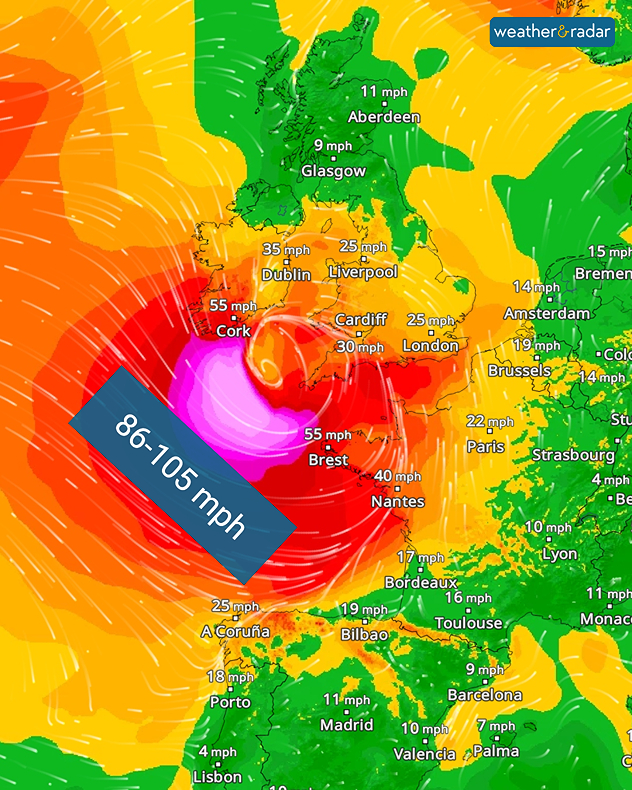
Storm Austen is set to bring severe weather from Thursday evening. Gale-force gusts and heavy rain is expected.

The storm system is currently expected to move through southern England, with gusts of up to 70 mph in the south-west, including Plymouth. The conditions will also reach western Europe, keep an eye on that if you have a holiday planned this half-term.

Trees may topple, damaging properties and vehicles. It will also cause problems for travellers: flights and ferries may be cancelled, and rail services are likely to be disrupted.

WindRadar: Severe gale-force winds are forecast over the Atlantic on Thursday evening.

The change begins on Thursday evening, with stormy weather stretching from Ireland, through the UK, into Brittany. Northern Spain will also feel the effects of the storm. On Friday, it will mainly affect the UK, the English Channel and northern France.

In isolated cases, hurricane-force gusts of around 95 miles per hour are even possible. Rainfall accumulations of 20 to 30 mm are also expected widely. Weather warnings for wind and rain are already live.

Severe weather warnings are activeread more
Weather & Radar editorial team
More on the topic
South-east saw a record-breaking drought. Rain coming but not enough. . . Thursday 15 October 2026
Split graphic showing yellow rainfall deficit areas across the UK and Ireland beside a dry, parched landscape with two people walking.
Thursday 15 October 2026

Rain coming but not enough

South-east saw a record-breaking drought
Former hurricane to record storm. Isaias affecting Europe. . . Wednesday 14 October 2026
WindRadar shows a powerful storm system south-west of Iceland. Red and purple colours indicate extreme wind speeds. Arrows show the direction of rotation, whilst a windsock symbol warns of a storm.
Wednesday 14 October 2026

Isaias affecting Europe

Former hurricane to record storm
Severe weather brings disruption. Gales and rain. . . Wednesday 14 October 2026
Split weather graphic showing winds up to 45 mph near Aberdeen and red, orange and yellow wind warning zones across Scotland and Ireland.
Wednesday 14 October 2026

Gales and rain

Severe weather brings disruption
All weather news
This might also interest you
Super Typhoon Bavi threatens Taiwan. Up to 1,000 mm of rain. . Weather Videos. Wednesday 8 July 2026
The image shows an intense tropical cyclone over the western Pacific, east of Taiwan and the Philippines. The centre of the system is depicted as a light purple and white vortex with a clearly visible eye, surrounded by a ring of red and orange areas indicating the strongest wind speeds. A white arrow marks the typhoon’s predicted track towards the north-west, in the direction of Taiwan. To the west of the storm lie the Philippines, with the cities of Manila and Cebu; to the north of these lies Taiwan, with Taipei. Further west, the Chinese coast, including Hong Kong, and parts of Vietnam can be seen. The coloured wind map shows predominantly green areas outside the storm’s core, indicating significantly weaker winds. White streamlines illustrate the typhoon’s anti-clockwise circulation in the Northern Hemisphere. The highest wind speeds are concentrated around the eye of the cyclone.
Weather VideosWednesday 8 July 2026

Up to 1,000 mm of rain

Super Typhoon Bavi threatens Taiwan
Historic Storm Éowyn arrives. On this day.... . . Saturday 24 January 2026
Split image showing a person in a yellow jacket struggling against strong winds and heavy rain on a street at night on the left, and an Irish wind forecast map on the right with red and purple shading, gusts up to 75 mph, and a wind warning icon, divided by a curved white line.
Saturday 24 January 2026

On this day...

Historic Storm Éowyn arrives
A frozen start to the weekend. Icy conditions. . . Friday 13 February 2026
UK temperature map dated 14.02 showing widespread subzero values in blue shading, with readings such as −4 in Glasgow, −3 in Dublin, and −2 in London, alongside a blue thermometer icon.
Friday 13 February 2026

Icy conditions

A frozen start to the weekend
All articles
Weather & Radar

Weather & Radar is also available on

Google Play StoreApp Store

Company

Contact us Privacy Policy Legal info Accessibility statement

Services

Uploader

Socials

facebooktwitteryouTubelinkList