Home
Weather Dublin
WeatherRadar
RainfallRadar
TemperatureRadar
WindRadar
LightningRadar
Weather News
Editor's Pick
Discover the app
Weather widget
Contact us
Apps
    Home / Editor's Pick /

    Frosty nights on the horizon in Europe

12:00
3 November 2026

Cold autumn air
Frosty nights on the horizon in Europe

Autumn is showing its chilly side this week. After a few windy and cloudy days, many parts of Europe are experiencing frosty nights.

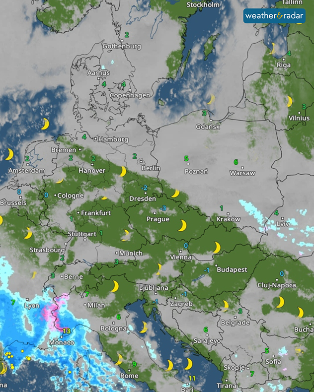
The night leading into Thursday, in particular, will be frosty from eastern Germany through Poland and into Ukraine.

Cold mornings on the continentread more

Overnight on Friday, the frost will continue to spread. Temperatures will then drop below 0°C across a wide swathe of land stretching from the Benelux countries to the Czech Republic, Austria, and Hungary. For many motorists, this means it will be time to get their ice scrapers out in the morning.

Reasons for the cold nights

WeatherRadar: Friday will be clear to slightly cloudy in many places allowing temperatures to drop below 0°C in some areas.

The clear skies and light breeze are the main reasons for the cold autumn nights.

Without the protective cloud cover, the ground can cool down particularly sharply at night. If there is hardly any wind, the air is mixed very little. This allows the cold air to accumulate directly above the ground. In addition, cooler air is flowing in from Eastern Europe, causing temperatures to drop further.

Weather & Radar editorial team

More on the topic

Severe weather risk at holiday spots. Across the Mediterranean. . Weather Videos. Friday 30 October 2026
Weather Radar shows a risk of flooding in Greece and Turkey. Meanwhile, the Wind Radar shows a storm system off Sicily with gusts of up to 50 miles per hour.
Weather VideosFriday 30 October 2026

Across the Mediterranean

Severe weather risk at holiday spots
Cyclone Arnab makes landfall in India. 100,000 people evacuated. . Weather Videos. Wednesday 28 October 2026
Split weather maps showing an intense cyclone off India's east coast near Visakhapatnam, with red-purple wind zones, heavy blue rain and warning symbols.
Weather VideosWednesday 28 October 2026

100,000 people evacuated

Cyclone Arnab makes landfall in India
Staying fairly blustery across Ireland. Autumn greetings. . . Thursday 29 October 2026
Wind map showing 35 mph winds near Galway and Cork, 25 mph near Dublin and Belfast, and lighter winds across western Britain, with a windsock symbol.
Thursday 29 October 2026

Autumn greetings

Staying fairly blustery across Ireland
All weather news

This might also interest you

Historic Storm Éowyn arrives. On this day.... . . Saturday 24 January 2026
Split image showing a person in a yellow jacket struggling against strong winds and heavy rain on a street at night on the left, and an Irish wind forecast map on the right with red and purple shading, gusts up to 75 mph, and a wind warning icon, divided by a curved white line.
Saturday 24 January 2026

On this day...

Historic Storm Éowyn arrives
Super Typhoon Bavi threatens Taiwan. Up to 1,000 mm of rain. . Weather Videos. Wednesday 8 July 2026
The image shows an intense tropical cyclone over the western Pacific, east of Taiwan and the Philippines. The centre of the system is depicted as a light purple and white vortex with a clearly visible eye, surrounded by a ring of red and orange areas indicating the strongest wind speeds. A white arrow marks the typhoon’s predicted track towards the north-west, in the direction of Taiwan. To the west of the storm lie the Philippines, with the cities of Manila and Cebu; to the north of these lies Taiwan, with Taipei. Further west, the Chinese coast, including Hong Kong, and parts of Vietnam can be seen. The coloured wind map shows predominantly green areas outside the storm’s core, indicating significantly weaker winds. White streamlines illustrate the typhoon’s anti-clockwise circulation in the Northern Hemisphere. The highest wind speeds are concentrated around the eye of the cyclone.
Weather VideosWednesday 8 July 2026

Up to 1,000 mm of rain

Super Typhoon Bavi threatens Taiwan
A frozen start to the weekend. Icy conditions. . . Friday 13 February 2026
UK temperature map dated 14.02 showing widespread subzero values in blue shading, with readings such as −4 in Glasgow, −3 in Dublin, and −2 in London, alongside a blue thermometer icon.
Friday 13 February 2026

Icy conditions

A frozen start to the weekend
All articles
Weather & Radar

Weather & Radar is also available on

Google Play StoreApp Store

Company

Contact us Privacy Policy Legal info Accessibility statement

Services

Uploader

Socials

facebooktwitteryouTubelinkList