Home
Weather Dublin
WeatherRadar
RainfallRadar
TemperatureRadar
WindRadar
LightningRadar
Weather News
Editor's Pick
Discover the app
Weather widget
Contact us
Apps
    Home / Editor's Pick /

    Across the Mediterranean - Severe weather risk at holiday spots

11:00
30 October 2026

Across the Mediterranean
Severe weather risk at holiday spots

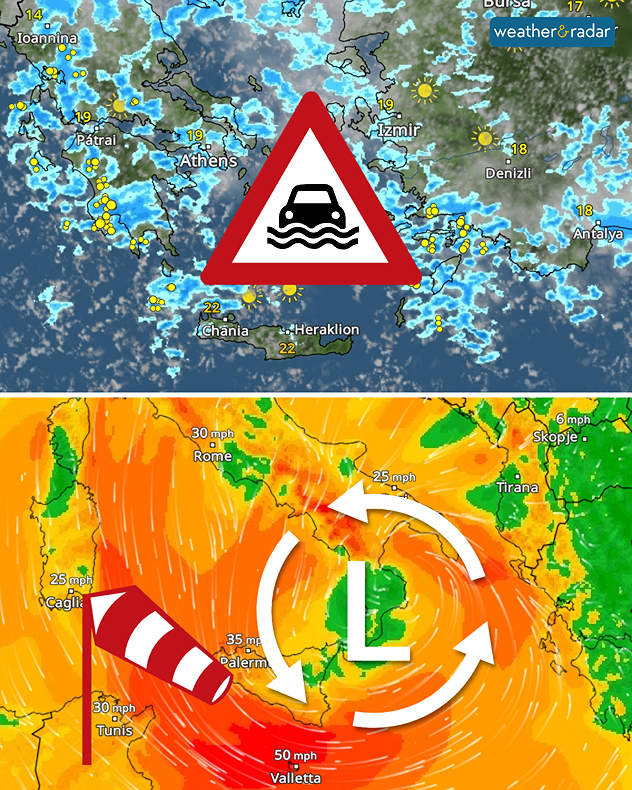
The Mediterranean region is experiencing no respite. From this weekend onwards, heavy rain and thunderstorms are once again expected, particularly in the Balkans, Greece, and western Turkey. Locally, rainfall could exceed 100 mm, and in some places even significantly more.

Popular holiday destinations such as Corfu, Rhodes and the Aegean islands are also affected. The heavy rainfall may lead to flooding.

Heavy rain with a risk of flooding in Greece and Turkey, and gale-force winds across southern Italy and Sicily.

The weather is also becoming increasingly unpleasant in southern Italy. There, too, around 100 mm of rain is forecast over the next few days. On top of that, stormy winds are expected from Monday, particularly in Sicily.

Are you currently travelling in the region, living there, or on holiday? Keep an eye on developments over the next few days on the WeatherRadar.

Click here for the latest weather radarread more

Weather & Radar editorial team

More on the topic

Autumn storms sweep across Europe. Boelo and more. . . Monday 26 October 2026
Split image showing a wind forecast with 60 mph near Aberdeen and 50 mph near Dublin, beside a fallen tree blocking a pavement near parked cars.
Monday 26 October 2026

Boelo and more

Autumn storms sweep across Europe
Overnight impacts as Austen hits. Power cuts, travel issues. . . Friday 23 October 2026
Split image showing floodwater surging beneath a railway bridge at night and a wind map with low pressure over the English Channel and 60 mph near Brest.
Friday 23 October 2026

Power cuts, travel issues

Overnight impacts as Austen hits
Stormy winds finally easing. By the end of the week. . . Tuesday 27 October 2026
Split wind maps showing winds of 25–40 mph across the UK and Ireland easing to 7–15 mph, with a white arrow indicating the change.
Tuesday 27 October 2026

By the end of the week

Stormy winds finally easing
All weather news

This might also interest you

Storm Chandra makes impact. Severe gales & heavy rain. . . Tuesday 27 January 2026
Split image showing strong winds over the UK on a forecast map and widespread rain and snow on a weather radar map.
Tuesday 27 January 2026

Severe gales & heavy rain

Storm Chandra makes impact
Seasonal warmth between spring thunder. Your weather - Your shots. . . Sunday 19 April 2026
Split image showing coastal sunset with layered lenticular clouds over rooftops and palm trees on the left, and a green valley with river and hills under soft daylight on the right.
Sunday 19 April 2026

Your weather - Your shots

Seasonal warmth between spring thunder
Flooding, gales, and heavy snow. Storm Chandra. . . Tuesday 27 January 2026
Split image showing aerial flooding in a town with muddy water covering roads on the left, and a rural road on the right blocked by heavy snowfall with vans stopped and a person walking in snow.
Tuesday 27 January 2026

Storm Chandra

Flooding, gales, and heavy snow
All articles
Weather & Radar

Weather & Radar is also available on

Google Play StoreApp Store

Company

Contact us Privacy Policy Legal info Accessibility statement

Services

Uploader

Socials

facebooktwitteryouTubelinkList