Home
Weather Dublin
WeatherRadar
RainfallRadar
TemperatureRadar
WindRadar
LightningRadar
Weather News
Editor's Pick
Discover the app
Weather widget
Contact us
Apps
    Home / Weather News /

    Breakfast brief - Hot & humid with thunderstorms

04:00
1 August 2024

Breakfast brief
Hot & humid with thunderstorms

Thunderstorm risk through Thursday.

Another very warm or hot day to come, humid too, with a risk of thunderstorms, especially later.

Kickstarting your morning

Welcome to the breakfast brief, preparing you for the day's weather, and offering a sneak peek at today's articles.

Weather outlook

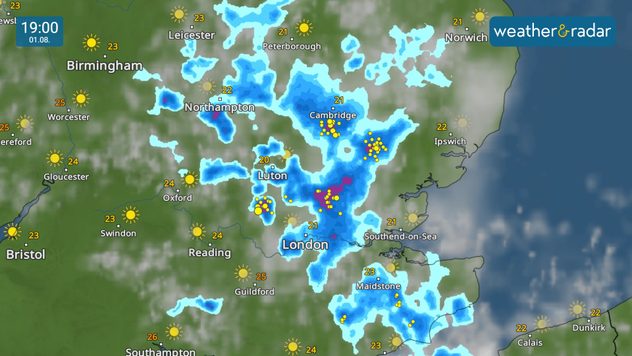
Following overnight and early morning thunderstorms across south-east England, the risk of thunderstorms continues into Thursday, particularly looking to ramp up once again into the evening.

The morning will also see outbreaks of rain across northern England to start, with further scattered showers developing elsewhere later.

Thunderstorms could produce torrential downpours bringing a risk of flash flooding, frequent lightning and even large hail, alongside gusty winds. Showers and thunderstorms will be hit or miss though, with some areas remaining dry.

Another very warm day to come too, locally hot, with temperatures hitting the mid to high twenties widely.

What's coming up in the news

Thunderstorms are expected to develop in parts of England later this afternoon, which we'll be tracking throughout the day to ensure you're fully informed on the situation.

Plus, we officially reached the threshold for an official heatwave. We'll be looking at this in more detail later this morning.

Did you miss these?

Your latest weather trendread more
Understanding dew pointread more
High thunderstorm riskread more

Shot from the world

We often dig into the archives each morning, but we receive so many picture submissions from around the world, we've decided to share some of the best!

If you want to get involved, just tap the image icon to upload your own, or use one of our dedicated uploaders for the UK or Ireland.

We share the best shots every Sunday here in the app, and throughout the week on our social channels!

Weather & Radar editorial team
More on the topic
Widespread thunderstorm risk in the UK. Heavy rain and hail too. . . Tuesday 25 August 2026
Split weather graphic showing a yellow thunderstorm warning across much of England alongside radar with heavy showers and frequent lightning around London and southeast England.
Tuesday 25 August 2026

Heavy rain and hail too

Widespread thunderstorm risk in the UK
Slow moving rain brings flooding. More alerts live. . . Thursday 27 August 2026
Weather radar at 11:00 on 27.08 showing widespread heavy rain from Liverpool through the Midlands to eastern England, with an arrow indicating rain moving north.
Thursday 27 August 2026

More alerts live

Slow moving rain brings flooding
Europe's storm situation still volatile. Supercell danger. . . Friday 28 August 2026
Split screen. On the left, a weather map of Europe showing thunderstorms, lightning and a warning symbol. On the right, a photograph of a severe thunderstorm
Friday 28 August 2026

Supercell danger

Europe's storm situation still volatile
All weather news
This might also interest you
Seasonal warmth between spring thunder. Your weather - Your shots. . . Sunday 19 April 2026
Split image showing coastal sunset with layered lenticular clouds over rooftops and palm trees on the left, and a green valley with river and hills under soft daylight on the right.
Sunday 19 April 2026

Your weather - Your shots

Seasonal warmth between spring thunder
New records for England and Wales. Broken again tomorrow?. . . Thursday 25 June 2026
Temperature map of southwest Britain on 25.06 showing extreme heat across southern Wales and southwest England, with Bute Park in Cardiff highlighted at 34.2°C and Yeovilton at 36.4°C amid widespread deep red heat zones.
Thursday 25 June 2026

Broken again tomorrow?

New records for England and Wales
Historic Storm Éowyn arrives. On this day.... . . Saturday 24 January 2026
Split image showing a person in a yellow jacket struggling against strong winds and heavy rain on a street at night on the left, and an Irish wind forecast map on the right with red and purple shading, gusts up to 75 mph, and a wind warning icon, divided by a curved white line.
Saturday 24 January 2026

On this day...

Historic Storm Éowyn arrives
All articles
Weather & Radar

Weather & Radar is also available on

Google Play StoreApp Store

Company

Contact us Privacy Policy Legal info Accessibility statement

Services

Uploader

Socials

facebooktwitteryouTubelinkList