Home
Weather Dublin
WeatherRadar
RainfallRadar
TemperatureRadar
WindRadar
LightningRadar
Weather News
Editor's Pick
Discover the app
Weather widget
Contact us
Apps
    Home / Editor's Pick /

    Back to freezing - Wintry feel to Thursday morning

09:00
25 March 2026

Back to freezing
Wintry feel to Thursday morning

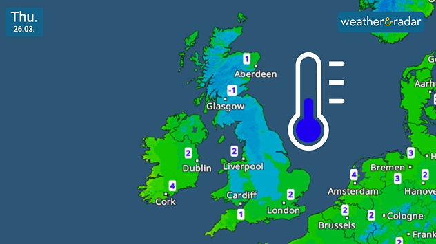
UK and Ireland temperature map dated Thu 26.03 showing widespread low values around −1 to 2 °C, with colder air across Scotland and a blue thermometer icon indicating chilly conditions.
Frosty start for many in the UK on Thursday.

Wrap up warm Thursday morning, the day starts frosty as temperatures drop to and around freezing overnight.

From central England and Wales, and north into Scotland, there will be a chilly bite for the start of the day.

Lows reach around -2 °C in north-west England, including Carlisle, and drop further in more rural areas of Scotland. This follows the return of snow for some on Wednesday.

Though mostly confined to higher ground, there is plenty of pink on the WeatherRadar. For most, this will reach the ground as rain, but particularly over hills wintry showers are expected.

This leads to Thursday morning, a cold start with sunshine which is soon masked by growing cloud cover.

Temperatures across Ireland and southern to eastern England also drop, but remain in the positive as Wednesday's gusting winds also fall away.

Ryan Hathaway
More on the topic
Stormy day in parts of the UK & Ireland. Lightning potential. . . Tuesday 4 August 2026
Satellite and lightning map of Scotland showing widespread rain and thunderstorms across the Highlands and western Scotland, with lightning strikes around the west coast and Hebrides. A thunderstorm icon highlights the active weather, while temperatures range from 15°C in Aberdeen to 24°C in Newcastle.
Tuesday 4 August 2026

Lightning potential

Stormy day in parts of the UK & Ireland
Japan braces itself for Typhoon Dolphin. Landslides feared. . . Wednesday 5 August 2026
Weather map showing a typhoon south of Japan. The centre of the storm is over the Pacific and is moving westwards. The coloured wind fields indicate its high intensity.
Wednesday 5 August 2026

Landslides feared

Japan braces itself for Typhoon Dolphin
Poor harvest expected after drought. Rain remains scarce. . . Thursday 6 August 2026
Split image showing an aerial view of drought-stricken parkland with dry yellow-brown grass surrounding a church on the left, and a temperature map of England and Wales on the right with temperatures reaching 30°C in southeast England.
Thursday 6 August 2026

Rain remains scarce

Poor harvest expected after drought
All weather news
This might also interest you
Seasonal warmth between spring thunder. Your weather - Your shots. . . Sunday 19 April 2026
Split image showing coastal sunset with layered lenticular clouds over rooftops and palm trees on the left, and a green valley with river and hills under soft daylight on the right.
Sunday 19 April 2026

Your weather - Your shots

Seasonal warmth between spring thunder
Flooding, gales, and heavy snow. Storm Chandra. . . Tuesday 27 January 2026
Split image showing aerial flooding in a town with muddy water covering roads on the left, and a rural road on the right blocked by heavy snowfall with vans stopped and a person walking in snow.
Tuesday 27 January 2026

Storm Chandra

Flooding, gales, and heavy snow
Super Typhoon Bavi threatens Taiwan. Up to 1,000 mm of rain. . Weather Videos. Wednesday 8 July 2026
The image shows an intense tropical cyclone over the western Pacific, east of Taiwan and the Philippines. The centre of the system is depicted as a light purple and white vortex with a clearly visible eye, surrounded by a ring of red and orange areas indicating the strongest wind speeds. A white arrow marks the typhoon’s predicted track towards the north-west, in the direction of Taiwan. To the west of the storm lie the Philippines, with the cities of Manila and Cebu; to the north of these lies Taiwan, with Taipei. Further west, the Chinese coast, including Hong Kong, and parts of Vietnam can be seen. The coloured wind map shows predominantly green areas outside the storm’s core, indicating significantly weaker winds. White streamlines illustrate the typhoon’s anti-clockwise circulation in the Northern Hemisphere. The highest wind speeds are concentrated around the eye of the cyclone.
Weather VideosWednesday 8 July 2026

Up to 1,000 mm of rain

Super Typhoon Bavi threatens Taiwan
All articles
Weather & Radar

Weather & Radar is also available on

Google Play StoreApp Store

Company

Contact us Privacy Policy Legal info Accessibility statement

Services

Uploader

Socials

facebooktwitteryouTubelinkList