Home
Weather Dublin
WeatherRadar
RainfallRadar
TemperatureRadar
WindRadar
LightningRadar
Weather News
Editor's Pick
Discover the app
Weather widget
Contact us
Apps
    Home / Editor's Pick /

    Autumn brings the first snow - Scandinavia turns white

08:44
7 October 2026

Scandinavia turns white
Autumn brings the first snow

Warm summer air has characterised large parts of Europe well into October. In many places, there were even a few more summer days. But that’s all over for now: the weather is shifting into autumn mode.

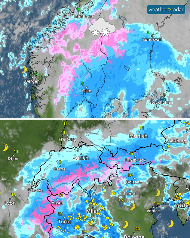
Low-pressure systems are taking hold, bringing rain, wind, and significantly colder air. The Alps will also feel the effects: during the night leading into Friday, the snow line will drop to around 1,500 metres, even in the higher valleys.

WeatherRadar: It’s starting to look like autumn.

Whilst more pleasant autumn weather will soon return to the Alps, the north of Europe will remain wet and unpleasant for longer. One low-pressure system after another is bringing a fair amount of snow, particularly to the mountains of Norway and Sweden.

One low-pressure system over the Bay of Biscay has met a cold front, bringing heavy rain to the south-east of the UK too.

Weather & Radar editorial team
More on the topic
Switch from drought to waterlogged. Ireland's new challenge. . . Thursday 1 October 2026
Split image showing widespread heavy rain across Ireland besid aerial farmland covered by extensive standing floodwater.
Thursday 1 October 2026

Ireland's new challenge

Switch from drought to waterlogged
Turbulence in the eastern Mediterranean. Floods and landslides. . . Friday 2 October 2026
Weather Radar showing a low-pressure system over the eastern Mediterranean
Friday 2 October 2026

Floods and landslides

Turbulence in the eastern Mediterranean
Sunset views mark the start of the month. Your weather - Your shots. . . Sunday 4 October 2026
Split image showing offshore wind turbines beneath a pink-purple sky and a fiery red-orange sunset above silhouetted rooftops.
Sunday 4 October 2026

Your weather - Your shots

Sunset views mark the start of the month
All weather news
This might also interest you
A frozen start to the weekend. Icy conditions. . . Friday 13 February 2026
UK temperature map dated 14.02 showing widespread subzero values in blue shading, with readings such as −4 in Glasgow, −3 in Dublin, and −2 in London, alongside a blue thermometer icon.
Friday 13 February 2026

Icy conditions

A frozen start to the weekend
Historic Storm Éowyn arrives. On this day.... . . Saturday 24 January 2026
Split image showing a person in a yellow jacket struggling against strong winds and heavy rain on a street at night on the left, and an Irish wind forecast map on the right with red and purple shading, gusts up to 75 mph, and a wind warning icon, divided by a curved white line.
Saturday 24 January 2026

On this day...

Historic Storm Éowyn arrives
Bright and warm conditions take hold. Spring-like outlook. . . Thursday 23 April 2026
Split UK map showing warm temperatures up to 21 degrees in orange on the left and clear sunny conditions with temperatures from 12 to 18 degrees on the right, with sun icons across the country.
Thursday 23 April 2026

Spring-like outlook

Bright and warm conditions take hold
All articles
Weather & Radar

Weather & Radar is also available on

Google Play StoreApp Store

Company

Contact us Privacy Policy Legal info Accessibility statement

Services

Uploader

Socials

facebooktwitteryouTubelinkList