Home
Weather Dublin
WeatherRadar
RainfallRadar
TemperatureRadar
WindRadar
LightningRadar
Weather News
Editor's Pick
Discover the app
Weather widget
Contact us
Apps
    Home / Editor's Pick /

    After 2022 devastation: Hurricane names Fiona & Ian retired

08:00
31 March 2023

After 2022 devastation
Hurricane names Fiona & Ian retired

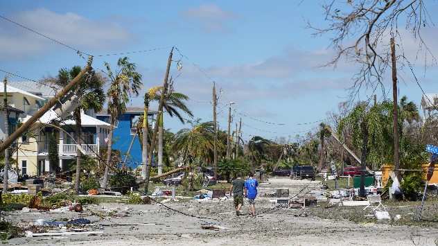
Hurricane damage
A scene of devastation in Fort Myers, Florida following Hurricane Ian. - © picture alliance

Both Fiona and Ian have been retired as hurricane names after causing multiple deaths and extensive damage in the US last year.

The World Meteorological Organisation has announced that the names will no longer be used, joining the 96 previously retired names.

It is common practice to retire the names of hurricanes which resulted in large-scale damages, almost all retired names were withdrawn following events causing billions of dollars in damage and multiple losses of life.

Hurricane Fiona resulted in approximately $3 billion in damages principally across the Caribbean where it impacted Puerto Rico and the Dominican Republic among others, and Canada last September.

Final figures suggest the hurricane was responsible for 29 deaths, peaking as a category 4 hurricane and becoming the most intense post-tropical cyclone to ever hit Canada.

In the system’s aftermath Puerto Rico, still recovering from Hurricane Maria, experienced widespread blackouts and severe flooding.

Extensive coverage of Hurricane Ian by Weather & Radar US

Hurricane Ian formed on September 23rd and would go on to become the deadliest system to hit Florida for over 80 years and the costliest ever.

Before reaching the US, Ian first impacted Cuba before intensifying en-route to Florida. It arrived as a category 4 system with sustained wind speeds of 150 mph leaving a trail of destruction.

At least 150 people were killed by, or as a result of, the system with Florida accounting for the majority of those reported.

Hurricane names are rotated annually and repeat every six years, from 2028 Fiona and Ian will be replaced by Farrah and Idris respectively.

Names are chosen by the World Meteorological Organisation and are used to help deliver information regarding severe events.

This year’s Atlantic hurricane season begins in June and will be kicked off by Hurricane Arlene.

Ryan Hathaway
More on the topic
Europe's storm situation still volatile. Supercell danger. . . Friday 28 August 2026
Split screen. On the left, a weather map of Europe showing thunderstorms, lightning and a warning symbol. On the right, a photograph of a severe thunderstorm
Friday 28 August 2026

Supercell danger

Europe's storm situation still volatile
Heavy showers prompt flash flood risk. Thunder and hail. . . Wednesday 26 August 2026
Weather radar map showing heavy shower around Nottingham and Leicester, with flood warning symbols highlighting areas at risk across the East Midlands.
Wednesday 26 August 2026

Thunder and hail

Heavy showers prompt flash flood risk
Violent thunderstorms mark summer's end. Hail and gusts of wind. . Weather Videos. Thursday 27 August 2026
Severe thunderstorm warning map showing a level 3 red zone from eastern France toward Belgium, surrounded by orange and yellow alerts extending into western Germany.
Weather VideosThursday 27 August 2026

Hail and gusts of wind

Violent thunderstorms mark summer's end
All weather news
This might also interest you
Storm Chandra makes impact. Severe gales & heavy rain. . . Tuesday 27 January 2026
Split image showing strong winds over the UK on a forecast map and widespread rain and snow on a weather radar map.
Tuesday 27 January 2026

Severe gales & heavy rain

Storm Chandra makes impact
Bright and warm conditions take hold. Spring-like outlook. . . Thursday 23 April 2026
Split UK map showing warm temperatures up to 21 degrees in orange on the left and clear sunny conditions with temperatures from 12 to 18 degrees on the right, with sun icons across the country.
Thursday 23 April 2026

Spring-like outlook

Bright and warm conditions take hold
A frozen start to the weekend. Icy conditions. . . Friday 13 February 2026
UK temperature map dated 14.02 showing widespread subzero values in blue shading, with readings such as −4 in Glasgow, −3 in Dublin, and −2 in London, alongside a blue thermometer icon.
Friday 13 February 2026

Icy conditions

A frozen start to the weekend
All articles
Weather & Radar

Weather & Radar is also available on

Google Play StoreApp Store

Company

Contact us Privacy Policy Legal info Accessibility statement

Services

Uploader

Socials

facebooktwitteryouTubelinkList