Home
Weather Dublin
WeatherRadar
RainfallRadar
TemperatureRadar
WindRadar
LightningRadar
Weather News
Editor's Pick
Discover the app
Weather widget
Contact us
Apps
    Home / Editor's Pick /

    Little sun to be seen - Dull start to the week under cloud cover

08:09
12 October 2026

Little sun to be seen
Dull start to the week under cloud cover

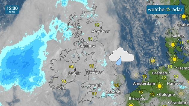
Weather map at 12:00 on 12.10 showing rain approaching western Ireland, scattered showers near eastern England and temperatures of 11–17°C.
The UK and Ireland are obscured by the day's cloud cover on the WeatherRadar.

It's a grey and dreary start to the week across the UK and Ireland with widespread cloud cover sticking around through Monday.

East Anglia will enjoy a sunny start, but quickly sees the clear sky disappear along with the rest of the country.

While there are some light showers around, a larger area of rain in the Atlantic moves mostly north, perhaps brushing the Hebrides.

Ryan Hathaway
More on the topic
Windswept Friday as gusts spread wide. Across the UK and Ireland. . . Thursday 8 October 2026
Wind map showing gusts of 40 mph near Dublin, Liverpool and Cardiff, 35 mph near Glasgow and London, and a strong wind warning symbol.
Thursday 8 October 2026

Across the UK and Ireland

Windswept Friday as gusts spread wide
Hurricane threatens the US coast. First storm of the season. . . Thursday 8 October 2026
The WindRadar shows a powerful hurricane off the US Gulf Coast. Wind speeds of 75 miles per hour are being recorded around the centre of the storm.
Thursday 8 October 2026

First storm of the season

Hurricane threatens the US coast
Autumn weather starting to appear. Your weather - Your shots. . . Sunday 11 October 2026
Split image showing golden sun rays shining through a tree in a misty field and a circular fallstreak hole in a blue sky with textured clouds.
Sunday 11 October 2026

Your weather - Your shots

Autumn weather starting to appear
All weather news
This might also interest you
Super Typhoon Bavi threatens Taiwan. Up to 1,000 mm of rain. . Weather Videos. Wednesday 8 July 2026
The image shows an intense tropical cyclone over the western Pacific, east of Taiwan and the Philippines. The centre of the system is depicted as a light purple and white vortex with a clearly visible eye, surrounded by a ring of red and orange areas indicating the strongest wind speeds. A white arrow marks the typhoon’s predicted track towards the north-west, in the direction of Taiwan. To the west of the storm lie the Philippines, with the cities of Manila and Cebu; to the north of these lies Taiwan, with Taipei. Further west, the Chinese coast, including Hong Kong, and parts of Vietnam can be seen. The coloured wind map shows predominantly green areas outside the storm’s core, indicating significantly weaker winds. White streamlines illustrate the typhoon’s anti-clockwise circulation in the Northern Hemisphere. The highest wind speeds are concentrated around the eye of the cyclone.
Weather VideosWednesday 8 July 2026

Up to 1,000 mm of rain

Super Typhoon Bavi threatens Taiwan
Bright and warm conditions take hold. Spring-like outlook. . . Thursday 23 April 2026
Split UK map showing warm temperatures up to 21 degrees in orange on the left and clear sunny conditions with temperatures from 12 to 18 degrees on the right, with sun icons across the country.
Thursday 23 April 2026

Spring-like outlook

Bright and warm conditions take hold
A stormy week in the skies above. Your weather - Your shots. . . Sunday 30 August 2026
Split image showing lightning branching beneath dark storm clouds above rooftops on the left and an orange-pink sunset over a calm sea on the right.
Sunday 30 August 2026

Your weather - Your shots

A stormy week in the skies above
All articles
Weather & Radar

Weather & Radar is also available on

Google Play StoreApp Store

Company

Contact us Privacy Policy Legal info Accessibility statement

Services

Uploader

Socials

facebooktwitteryouTubelinkList