Home
Weather Dublin
WeatherRadar
RainfallRadar
TemperatureRadar
WindRadar
LightningRadar
Weather News
Editor's Pick
Discover the app
Weather widget
Contact us
Apps
    Home / Editor's Pick /

    Heavy showers prompt flash flood risk

08:51
26 August 2026

Thunder and hail
Heavy showers prompt flash flood risk

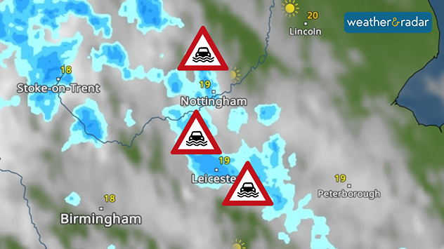
Weather radar map showing heavy shower around Nottingham and Leicester, with flood warning symbols highlightning areas at risk across the East Midlands.
Flood alerts are active across parts of the Midlands.

A number of flood alerts are already live Wednesday morning as heavy showers bring a renewed risk of flash flooding in parts of England and Wales.

Up to 50 mm of rain could fall through day, with heavy showers moving northwards in the morning. More widely accumulations of 20-30 mm are expected. Where the heaviest rain falls, surface flooding may arise.

Currently, five flood alerts cover parts of the Midlands from northern Nottinghamshire's River Maun down to tributaries in Leicester.

Further alerts are expected on Thursday, with another day of heavy rain and potential thunderstorms.

Staying on top of the flood risk

Flood alerts, warnings, and severe warnings are a live service and prone to change during the day. Keep an eye on official sources for the latest in your area.

Again, accumulations of 20 to 30 mm in a few hours are expected across the English Midlands into Wales, but with potentially higher total amounts of up to 75 mm for a few east facing areas at higher altitude.

Alongside the rainfall, the current set-up is also ripe for the outbreak of thunderstorms on both days and large hailstones are possible on Thursday too.

Ryan Hathaway
More on the topic
Widespread thunderstorm risk in the UK. Heavy rain and hail too. . . Tuesday 25 August 2026
Split weather graphic showing a yellow thunderstorm warning across much of England alongside radar with heavy showers and frequent lightning around London and southeast England.
Tuesday 25 August 2026

Heavy rain and hail too

Widespread thunderstorm risk in the UK
Flood alerts after heavy showers. Risk in northern England. . . Thursday 20 August 2026
Weather radar map showing persistent heavy rain across northern England around Liverpool, Manchester and Newcastle, with a flood warning symbol highlighting the risk.
Thursday 20 August 2026

Risk in northern England

Flood alerts after heavy showers
Late-summer views as shooting stars fly. Your weather - Your shots. . . Sunday 23 August 2026
Split image showing a meteor streaking through a star-filled night sky on the left and wispy white cirrus clouds sweeping across a vivid blue daytime sky on the right.
Sunday 23 August 2026

Your weather - Your shots

Late-summer views as shooting stars fly
All weather news
This might also interest you
Seasonal warmth between spring thunder. Your weather - Your shots. . . Sunday 19 April 2026
Split image showing coastal sunset with layered lenticular clouds over rooftops and palm trees on the left, and a green valley with river and hills under soft daylight on the right.
Sunday 19 April 2026

Your weather - Your shots

Seasonal warmth between spring thunder
Super Typhoon Bavi threatens Taiwan. Up to 1,000 mm of rain. . Weather Videos. Wednesday 8 July 2026
The image shows an intense tropical cyclone over the western Pacific, east of Taiwan and the Philippines. The centre of the system is depicted as a light purple and white vortex with a clearly visible eye, surrounded by a ring of red and orange areas indicating the strongest wind speeds. A white arrow marks the typhoon’s predicted track towards the north-west, in the direction of Taiwan. To the west of the storm lie the Philippines, with the cities of Manila and Cebu; to the north of these lies Taiwan, with Taipei. Further west, the Chinese coast, including Hong Kong, and parts of Vietnam can be seen. The coloured wind map shows predominantly green areas outside the storm’s core, indicating significantly weaker winds. White streamlines illustrate the typhoon’s anti-clockwise circulation in the Northern Hemisphere. The highest wind speeds are concentrated around the eye of the cyclone.
Weather VideosWednesday 8 July 2026

Up to 1,000 mm of rain

Super Typhoon Bavi threatens Taiwan
Flooding, gales, and heavy snow. Storm Chandra. . . Tuesday 27 January 2026
Split image showing aerial flooding in a town with muddy water covering roads on the left, and a rural road on the right blocked by heavy snowfall with vans stopped and a person walking in snow.
Tuesday 27 January 2026

Storm Chandra

Flooding, gales, and heavy snow
All articles
Weather & Radar

Weather & Radar is also available on

Google Play StoreApp Store

Company

Contact us Privacy Policy Legal info Accessibility statement

Services

Uploader

Socials

facebooktwitteryouTubelinkList