Home
Weather Dublin
WeatherRadar
RainfallRadar
TemperatureRadar
WindRadar
LightningRadar
Weather News
Editor's Pick
Discover the app
Weather widget
Contact us
Apps
    Home / Editor's Pick /

    Turbulent week ahead - Gales build again for Ireland

09:01
12 October 2026

Turbulent week ahead
Gales build again for Ireland

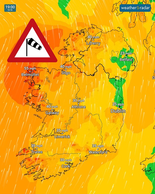
Wind forecast for 19:00 on 12.10 showing gusts up to 55 mph near Belmullet, 40 mph in Sligo and Galway, and a strong wind warning symbol.
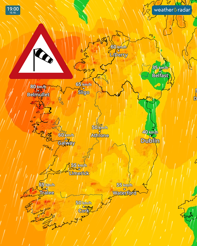
Wind forecast for 19:00 on 12.10 showing 80 km/h near Belmullet, 65 km/h near Sligo and 60 km/h near Galway and Derry, with a wind warning symbol.
1/2
Gusts spread again by Monday evening. (Swipe for km/h).

Conditions are calm across Ireland to start Monday, but by the evening, gusts spread again with gales in parts of the country.

By midday, the winds will start picking up in Co. Kerry and Co. Cork as they spread north through the country.

In the evening, Co. Mayo can expect gales. No land warnings have been issued but a marine weather warning for gales covers the north-western waters.

With rainfall moving in from the Atlantic along with the stronger winds, it will be an unpleasant evening in the west.

Similar conditions will be felt through the week, particularly on Wednesday, with little reprieve until Thursday at the earliest from the gusts.

Ryan Hathaway
More on the topic
Heavy rain builds through the day. Irish warnings issued. . . Thursday 8 October 2026
Weather map showing widespread heavy rain across western and central Ireland, with blue precipitation bands and a red triangular rain warning symbol.
Thursday 8 October 2026

Irish warnings issued

Heavy rain builds through the day
Tornadoes rage across Sicily. Cars sent flying. . Weather Videos. Saturday 10 October 2026
A split image showing a tornado off the coast of Sicily on the left-hand side. A dark cloud funnel extends down to the ground or the water’s surface; houses and palm trees can be seen in the foreground. On the right, a weather map near Marsala shows heavy rainfall in pink and blue, numerous flashes of lightning as yellow dots, and a white whirlwind symbol.
Weather VideosSaturday 10 October 2026

Cars sent flying

Tornadoes rage across Sicily
Hurricane threatens the US coast. First storm of the season. . . Thursday 8 October 2026
The WindRadar shows a powerful hurricane off the US Gulf Coast. Wind speeds of 75 miles per hour are being recorded around the centre of the storm.
Thursday 8 October 2026

First storm of the season

Hurricane threatens the US coast
All weather news
This might also interest you
Seasonal warmth between spring thunder. Your weather - Your shots. . . Sunday 19 April 2026
Split image showing coastal sunset with layered lenticular clouds over rooftops and palm trees on the left, and a green valley with river and hills under soft daylight on the right.
Sunday 19 April 2026

Your weather - Your shots

Seasonal warmth between spring thunder
Super Typhoon Bavi threatens Taiwan. Up to 1,000 mm of rain. . Weather Videos. Wednesday 8 July 2026
The image shows an intense tropical cyclone over the western Pacific, east of Taiwan and the Philippines. The centre of the system is depicted as a light purple and white vortex with a clearly visible eye, surrounded by a ring of red and orange areas indicating the strongest wind speeds. A white arrow marks the typhoon’s predicted track towards the north-west, in the direction of Taiwan. To the west of the storm lie the Philippines, with the cities of Manila and Cebu; to the north of these lies Taiwan, with Taipei. Further west, the Chinese coast, including Hong Kong, and parts of Vietnam can be seen. The coloured wind map shows predominantly green areas outside the storm’s core, indicating significantly weaker winds. White streamlines illustrate the typhoon’s anti-clockwise circulation in the Northern Hemisphere. The highest wind speeds are concentrated around the eye of the cyclone.
Weather VideosWednesday 8 July 2026

Up to 1,000 mm of rain

Super Typhoon Bavi threatens Taiwan
A frozen start to the weekend. Icy conditions. . . Friday 13 February 2026
UK temperature map dated 14.02 showing widespread subzero values in blue shading, with readings such as −4 in Glasgow, −3 in Dublin, and −2 in London, alongside a blue thermometer icon.
Friday 13 February 2026

Icy conditions

A frozen start to the weekend
All articles
Weather & Radar

Weather & Radar is also available on

Google Play StoreApp Store

Company

Contact us Privacy Policy Legal info Accessibility statement

Services

Uploader

Socials

facebooktwitteryouTubelinkList