Home
Weather Dublin
WeatherRadar
RainfallRadar
TemperatureRadar
WindRadar
LightningRadar
Weather News
Editor's Pick
Discover the app
Weather widget
Contact us
Apps
    Home / Editor's Pick /

    Ireland & Scotland - Heavier rainfall over the week for some

16:00
28 July 2026

Ireland & Scotland
Heavier rainfall over the week for some

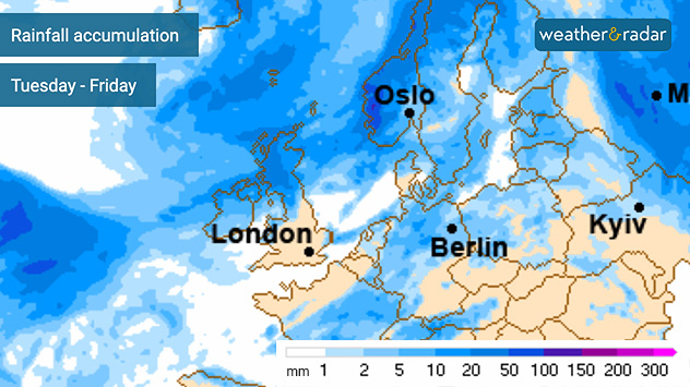
Rainfall accumulation forecast map for Europe from Tuesday to Friday showing the highest totals across the British Isles, Scandinavia, and parts of the North Atlantic in darker blue shades, with lower totals across much of central and southeastern Europe in lighter colours.
Total accumulated rain this week sees Scotland heavily coated by Friday evening.

The next heatwave grips the south-east of the UK, but across Ireland and much of Scotland the week will bring heavier bouts of rainfall.

Across western Scotland, up to 60 mm of rain could fall by the end of the week. With the total spread over three days this is unlikely to cause any significant disruption.

Total rainfall accumulation across Ireland is lower, with Northern Ireland and the north-west of Ireland seeing the most over the coming days.

Further south, the dry spell continues with just coastal East Anglia likely to see any significant rain. Even this is much lower than that seen to the north and west.

A front pushing through the area is responsible for the renewed rainfall and for keeping temperatures cooler with Ireland and Scotland sitting under low pressure. Much of England and Europe remain in the grip of high pressure keeping conditions settled and warm.

Portree

Tu
13
17
We
12
16
Th
11
13
Fr
8
15
Sa
11
16
Su
12
15
Mo
11
17
Tu
11
17
We
12
17
Th
12
17
Fr
12
17
Sa
12
17
Su
12
17
Mo
12
19
Max (°C)
Min (°C)
moreless

Galway

Tu
17
20
We
17
19
Th
11
18
Fr
11
18
Sa
11
19
Su
13
20
Mo
11
19
Tu
13
21
We
13
21
Th
12
20
Fr
11
19
Sa
13
21
Su
13
21
Mo
13
22
Max (°C)
Min (°C)
moreless

Belfast

Tu
19
25
We
17
19
Th
11
18
Fr
10
17
Sa
10
19
Su
12
19
Mo
10
18
Tu
13
21
We
13
20
Th
12
19
Fr
11
18
Sa
13
19
Su
13
21
Mo
13
20
Max (°C)
Min (°C)
moreless

Thurso

Tu
12
21
We
12
18
Th
9
14
Fr
8
16
Sa
10
17
Su
10
17
Mo
10
18
Tu
9
15
We
9
15
Th
8
17
Fr
9
18
Sa
10
18
Su
10
18
Mo
10
18
Max (°C)
Min (°C)
moreless

Glasgow

Tu
15
21
We
16
17
Th
11
17
Fr
10
16
Sa
11
18
Su
9
18
Mo
10
19
Tu
11
19
We
12
19
Th
11
19
Fr
10
18
Sa
12
20
Su
12
20
Mo
12
20
Max (°C)
Min (°C)
moreless
Ryan Hathaway
More on the topic
Fourth heatwave of the year. Peaking Wednesday. . . Tuesday 28 July 2026
Temperature map of England and Wales on Wednesday 29.07 showing widespread hot conditions, with temperatures reaching 33°C near Cambridge, 32°C around London, Norwich, and Southend-on-Sea, and a large heat warning symbol highlighting elevated heat risk.
Tuesday 28 July 2026

Peaking Wednesday

Fourth heatwave of the year
Parts of England inching towards drought. Low rivers & reservoirs. . . Wednesday 22 July 2026
People relaxing in a park during hot weather ,with one person sunbathing on dry yellow grass beneath large leafy trees under a blue sky with scattered fair-weather clouds.
Wednesday 22 July 2026

Low rivers & reservoirs

Parts of England inching towards drought
Forest fires are getting out of control. Spain and France. . . Saturday 25 July 2026
A split-screen image featuring a photograph and a weather map. On the left, thick, dark-grey smoke rises from several fire sites in a wooded coastal area; a calm stretch of water can be seen in the foreground. On the right, a weather map shows south-western France and northern Spain. A red arrow points from the Atlantic towards the French Atlantic coast, symbolising an onshore wind. Sunny weather is forecast for Bordeaux at around 20 degrees, and Bilbao is also expected to be sunny at around 27 degrees. A large warning sign with a flame symbol indicates an increased risk of forest fires.
Saturday 25 July 2026

Spain and France

Forest fires are getting out of control
All weather news
This might also interest you
Storm Chandra makes impact. Severe gales & heavy rain. . . Tuesday 27 January 2026
Split image showing strong winds over the UK on a forecast map and widespread rain and snow on a weather radar map.
Tuesday 27 January 2026

Severe gales & heavy rain

Storm Chandra makes impact
Historic Storm Éowyn arrives. On this day.... . . Saturday 24 January 2026
Split image showing a person in a yellow jacket struggling against strong winds and heavy rain on a street at night on the left, and an Irish wind forecast map on the right with red and purple shading, gusts up to 75 mph, and a wind warning icon, divided by a curved white line.
Saturday 24 January 2026

On this day...

Historic Storm Éowyn arrives
Bright and warm conditions take hold. Spring-like outlook. . . Thursday 23 April 2026
Split UK map showing warm temperatures up to 21 degrees in orange on the left and clear sunny conditions with temperatures from 12 to 18 degrees on the right, with sun icons across the country.
Thursday 23 April 2026

Spring-like outlook

Bright and warm conditions take hold
All articles
Weather & Radar

Weather & Radar is also available on

Google Play StoreApp Store

Company

Contact us Privacy Policy Legal info Accessibility statement

Services

Uploader

Socials

facebooktwitteryouTubelinkList