Home
Weather Dublin
WeatherRadar
RainfallRadar
TemperatureRadar
WindRadar
LightningRadar
Weather News
Editor's Pick
Discover the app
Weather widget
Contact us
Apps
    Home / Editor's Pick /

    Low rivers & reservoirs - Parts of England inching towards drought

16:00
22 July 2026

Low rivers & reservoirs
Parts of England inching towards drought

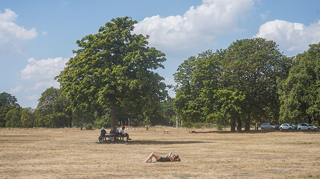
People relaxing in a park during hot weather ,with one person sunbathing on dry yellow grass beneath large leafy trees under a blue sky with scattered fair-weather clouds.
Little rainfall has left grass at Wimbledon Common parched and yellow. - © picture alliance / Visually | amer ghazzal

Numerous areas across England are facing drought amid a dry spell which has left rivers and reservoirs at low levels.

Just 13% of rivers across the UK are at normal levels according to the National Drought Group. This follows a declaration of prolonged dry weather, one step down from an official drought status in 13 areas.

Amid general low levels, the Rivers Avon, Cam, Derwent, Swale, Tone, Wye, and Yare have been singled out as exceptionally low while six reservoirs are "notably low" with Blagdon reservoir denoted as "exceptionally low".

As a result, farmers are warning of potential food shortages in supermarkets for later in the year with some crops failing in the hot and dry weather and an earlier harvest of others with conditions hastening the growth.

Little rainfall means water restrictions also continue to spread. On Tuesday, Thames Water became the latest water company to implement a hosepipe ban for their customers.

Parts of England have gone 30 days without any rainfall, including London where the last rain recorded was on June 23rd, while central England is experiencing the longest dry spell for three decades.

Ryan Hathaway
More on the topic
Drought across large parts of Europe. High fire risk. . . Monday 20 July 2026
Split image showing a Europe rainfall anomaly map on the left with widespread dry conditions across much of the continent, and a cracked, parched field on the right alongside a wildfire warning symbol highlighting elevated fire risk.
Monday 20 July 2026

High fire risk

Drought across large parts of Europe
Severe damage along the Adriatic coast. Huge hail and storms. . . Wednesday 22 July 2026
Two hands are holding huge hailstones; next to them is a weather map showing thunderstorms and frequent lightning over the Adriatic coast and the western Balkans.
Wednesday 22 July 2026

Huge hail and storms

Severe damage along the Adriatic coast
New heatwave in southern Europe. Up to 45 degrees in Spain. . . Tuesday 21 July 2026
Split temperature map showing extreme heat across Spain on the left and Greece on the right, with temperatures reaching 44°C near Murcia, around 40°C in parts of Greece, and a large thermometer icon highlighting dangerous heat.
Tuesday 21 July 2026

Up to 45 degrees in Spain

New heatwave in southern Europe
All weather news
This might also interest you
Turbulent weather in the Canary Islands. Storm and rain. . . Friday 12 December 2025
Weather graphic showing rain and wind fields over the Canary Islands and a central warning symbol.
Friday 12 December 2025

Storm and rain

Turbulent weather in the Canary Islands
Flooding, gales, and heavy snow. Storm Chandra. . . Tuesday 27 January 2026
Split image showing aerial flooding in a town with muddy water covering roads on the left, and a rural road on the right blocked by heavy snowfall with vans stopped and a person walking in snow.
Tuesday 27 January 2026

Storm Chandra

Flooding, gales, and heavy snow
Long-term trends need a pinch of salt. 40 °C in July?. . . Tuesday 30 June 2026
Temperature radar of 2022 heatwave where the all-time temperature record in the UK was set. Warning symbol overlain.
Tuesday 30 June 2026

40 °C in July?

Long-term trends need a pinch of salt
All articles
Weather & Radar

Weather & Radar is also available on

Google Play StoreApp Store

Company

Contact us Privacy Policy Legal info Accessibility statement

Services

Uploader

Socials

facebooktwitteryouTubelinkList