Home
Weather Dublin
WeatherRadar
RainfallRadar
TemperatureRadar
WindRadar
LightningRadar
Weather News
Editor's Pick
Discover the app
Weather widget
Contact us
Apps
    Home / Editor's Pick /

    Severe weather in Turkey and Greece – torrential rain and storms

11:00
15 October 2026

Torrential rain and storms
Severe weather hits Turkey and Greece

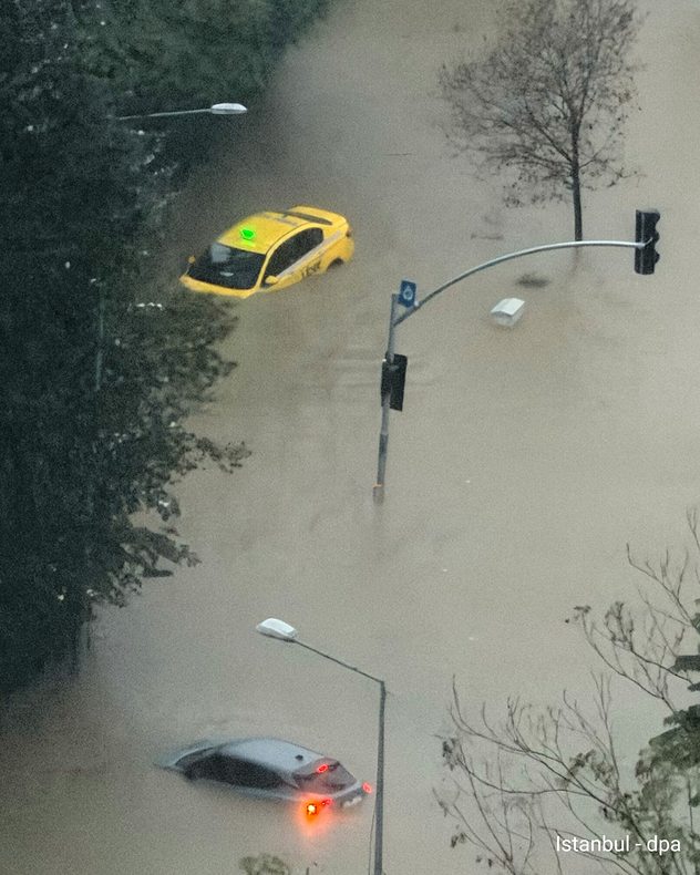
Heavy rain flooded streets and underpasses in Istanbul, Turkey, on Wednesday. Cars and buses became stuck in the floodwaters, and there were landslides in some places. Schools were closed on Thursday.

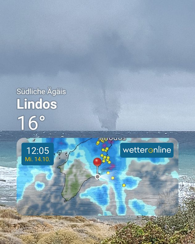
It wasn’t just Turkey that was hit hard. Shortly before that, storms had already caused extensive damage in Greece. Roads and houses were flooded, trees were uprooted, and several islands were left without power.

A flooded road in Istanbul. A yellow taxi and another car are submerged deep in the brown floodwater. The traffic light poles are also sticking out of the floodwater.
A white delivery van is parked on a flooded road under a bridge in Istanbul. The water reaches up to the wheels and reflects the vehicle’s lights.
Brown floodwater has filled the interior of a bus in Istanbul. Several passengers are sitting on raised seats, whilst the central aisle is flooded.
Several men, including emergency services personnel in protective clothing, are standing on the bucket of a wheel loader in Istanbul at night. They are standing above a flooded road.
A waterspout stretches off the coast of Lindos on Rhodes, from dark storm clouds down to the sea surface. In the foreground, the weather radar shows areas of rain and lightning.
1/6

A man lost his life in the floods on Rhodes. Gusts of wind over 60 miles per hour disrupted ferry services, and flights were diverted.

Anyone currently on holiday in the region, particularly with schools breaking up for half-term, should continue to be cautious and heed local warnings. There will be further downpours and thunderstorms until the weekend.

Severe weather risk remains highMore thunderstorms on the WeatherRadar
Tommy Kühnlein
More on the topic
Warnings for a windswept Wednesday. Coastal gales. . . Tuesday 13 October 2026
Wind map showing 45 mph near Aberdeen, 40 mph near Glasgow and Cork, and red strong wind warning symbols across western Scotland and Ireland.
Tuesday 13 October 2026

Coastal gales

Warnings for a windswept Wednesday
Gales build again for Ireland. Turbulent week ahead. . . Monday 12 October 2026
Wind map showing 40 mph winds near Galway, 30 mph near Cork, 25 mph near Dublin and 23 mph near Belfast, with a windsock symbol.
Monday 12 October 2026

Turbulent week ahead

Gales build again for Ireland
Severe storms expected in the Med. Risk of flooding. . . Tuesday 13 October 2026
The weather radar and warning map show severe thunderstorms and heavy rain in Greece and western Turkey.
Tuesday 13 October 2026

Risk of flooding

Severe storms expected in the Med
All weather news
This might also interest you
Bright and warm conditions take hold. Spring-like outlook. . . Thursday 23 April 2026
Split UK map showing warm temperatures up to 21 degrees in orange on the left and clear sunny conditions with temperatures from 12 to 18 degrees on the right, with sun icons across the country.
Thursday 23 April 2026

Spring-like outlook

Bright and warm conditions take hold
Super Typhoon Bavi threatens Taiwan. Up to 1,000 mm of rain. . Weather Videos. Wednesday 8 July 2026
The image shows an intense tropical cyclone over the western Pacific, east of Taiwan and the Philippines. The centre of the system is depicted as a light purple and white vortex with a clearly visible eye, surrounded by a ring of red and orange areas indicating the strongest wind speeds. A white arrow marks the typhoon’s predicted track towards the north-west, in the direction of Taiwan. To the west of the storm lie the Philippines, with the cities of Manila and Cebu; to the north of these lies Taiwan, with Taipei. Further west, the Chinese coast, including Hong Kong, and parts of Vietnam can be seen. The coloured wind map shows predominantly green areas outside the storm’s core, indicating significantly weaker winds. White streamlines illustrate the typhoon’s anti-clockwise circulation in the Northern Hemisphere. The highest wind speeds are concentrated around the eye of the cyclone.
Weather VideosWednesday 8 July 2026

Up to 1,000 mm of rain

Super Typhoon Bavi threatens Taiwan
Storm Chandra makes impact. Severe gales & heavy rain. . . Tuesday 27 January 2026
Split image showing strong winds over the UK on a forecast map and widespread rain and snow on a weather radar map.
Tuesday 27 January 2026

Severe gales & heavy rain

Storm Chandra makes impact
All articles
Weather & Radar

Weather & Radar is also available on

Google Play StoreApp Store

Company

Contact us Privacy Policy Legal info Accessibility statement

Services

Uploader

Socials

facebooktwitteryouTubelinkList