Home
Weather Dublin
WeatherRadar
RainfallRadar
TemperatureRadar
WindRadar
LightningRadar
Weather News
Editor's Pick
Discover the app
Weather widget
Contact us
Apps
    Home / Editor's Pick /

    Your weather - Your shots: The first collection of spring

10:00
8 March 2026

Your weather - Your shots
The first collection of spring

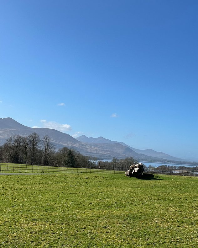
Wide green field with a large tree stump in the foreground, bare trees along a fence line, and distant mountains and a lake under a clear blue sky.
Bright sun setting over calm ocean with a deep golden sky, long shimmering reflection stretching across the water toward the shore.
Silhouetted rooftops at sunset with a small decorative windmill, weather vane, and bird statue on poles, as the low sun shines through bare tree branches.
Silhouetted palm tree with wide fronds against a soft pink and blue sunrise sky, with rooftops and garden structures faintly visible below.
1/4
This spring scene was captured at the Killarney National Park in Co. Kerry. - © Weather & Radar Uploader

The arrival of Saharan dust in southern England added an extra vibrancy to the sunrise and sunsets that ended the week.

No such haze in Ireland, where resplendent blue skies were seen on a chillier week.

Send in your pictures, or use our new video feature to capture the scene complete with WeatherRadar, and use the uploaders for the UK or Ireland to appear here next week.

Capture your moment and your weatherNew in the app
Weather & Radar editorial team
More on the topic
Heat warnings cover much of Ireland. Until the weekend. . . Thursday 16 July 2026
Temperature map of Ireland showing warm to hot conditions nationwide, with temperatures ranging from 27°C in Galway to 23°C in Dublin. A heat warning symbol to the west indicates elevated temperatures.
Thursday 16 July 2026

Until the weekend

Heat warnings cover much of Ireland
Drought across large parts of Europe. High fire risk. . . Monday 20 July 2026
Split image showing a Europe rainfall anomaly map on the left with widespread dry conditions across much of the continent, and a cracked, parched field on the right alongside a wildfire warning symbol highlighting elevated fire risk.
Monday 20 July 2026

High fire risk

Drought across large parts of Europe
Heatwave breaks after remarkable run. Two weeks of heat. . . Monday 20 July 2026
Split image showing the London skyline in hazy golden sunshine on the left and a July temperature anomaly map of Europe on the right, with above-average temperatures across the UK, Ireland, and much of western Europe highlighted in red alongside a thermometer icon.
Monday 20 July 2026

Two weeks of heat

Heatwave breaks after remarkable run
All weather news
This might also interest you
New records for England and Wales. Broken again tomorrow?. . . Thursday 25 June 2026
Temperature map of southwest Britain on 25.06 showing extreme heat across southern Wales and southwest England, with Bute Park in Cardiff highlighted at 34.2°C and Yeovilton at 36.4°C amid widespread deep red heat zones.
Thursday 25 June 2026

Broken again tomorrow?

New records for England and Wales
Historic Storm Éowyn arrives. On this day.... . . Saturday 24 January 2026
Split image showing a person in a yellow jacket struggling against strong winds and heavy rain on a street at night on the left, and an Irish wind forecast map on the right with red and purple shading, gusts up to 75 mph, and a wind warning icon, divided by a curved white line.
Saturday 24 January 2026

On this day...

Historic Storm Éowyn arrives
Super Typhoon Bavi threatens Taiwan. Up to 1,000 mm of rain. . Weather Videos. Wednesday 8 July 2026
The image shows an intense tropical cyclone over the western Pacific, east of Taiwan and the Philippines. The centre of the system is depicted as a light purple and white vortex with a clearly visible eye, surrounded by a ring of red and orange areas indicating the strongest wind speeds. A white arrow marks the typhoon’s predicted track towards the north-west, in the direction of Taiwan. To the west of the storm lie the Philippines, with the cities of Manila and Cebu; to the north of these lies Taiwan, with Taipei. Further west, the Chinese coast, including Hong Kong, and parts of Vietnam can be seen. The coloured wind map shows predominantly green areas outside the storm’s core, indicating significantly weaker winds. White streamlines illustrate the typhoon’s anti-clockwise circulation in the Northern Hemisphere. The highest wind speeds are concentrated around the eye of the cyclone.
Weather VideosWednesday 8 July 2026

Up to 1,000 mm of rain

Super Typhoon Bavi threatens Taiwan
All articles
Weather & Radar

Weather & Radar is also available on

Google Play StoreApp Store

Company

Contact us Privacy Policy Legal info Accessibility statement

Services

Uploader

Socials

facebooktwitteryouTubelinkList