Home
Weather Dublin
WeatherRadar
RainfallRadar
TemperatureRadar
WindRadar
LightningRadar
Weather News
Editor's Pick
Discover the app
Weather widget
Contact us
Apps
    Home / Editor's Pick /

    Weekend weather - Large temperature contrasts in Europe

10:00
19 September 2025

Weekend weather
Large temperature contrasts in Europe

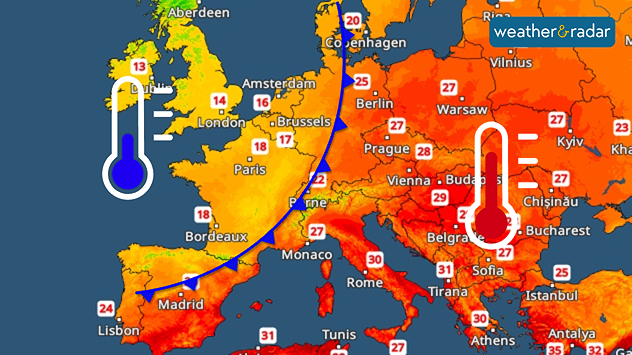
TemperatureRadar: A cold front will bring significantly colder air to Western Europe over the weekend.

A high-pressure system is still bringing perfect late summer weather to many parts of Central Europe, moving east over the weekend, with a pronounced cold front arriving in the west.

This will result in a clear division in the weather across Europe, particularly on Sunday. Behind the front, it will be autumnal and cool, with widespread rain from northern Spain across France to the Benelux countries and the United Kingdom and Ireland.

Meanwhile, there is plenty of sunshine from the Mediterranean region to Eastern Europe and the Baltic States. It is also very warm, with temperatures ranging from 25 degrees in Lithuania to 30 degrees in Greece.

Split on SundayTemperatureRadar forecast
Michael Krucker
Ryan Hathaway
More on the topic
Heavy rain builds through the day. Irish warnings issued. . . Thursday 8 October 2026
Weather map showing widespread heavy rain across western and central Ireland, with blue precipitation bands and a red triangular rain warning symbol.
Thursday 8 October 2026

Irish warnings issued

Heavy rain builds through the day
Much of Europe in storm mode. Twin low-pressure systems. . . Friday 9 October 2026
WindRadar for Europe, showing wind speeds of up to 40 mph and wind socks over particularly windy regions.
Friday 9 October 2026

Twin low-pressure systems

Much of Europe in storm mode
Windswept Friday as gusts spread wide. Across the UK and Ireland. . . Thursday 8 October 2026
Wind map showing gusts of 40 mph near Dublin, Liverpool and Cardiff, 35 mph near Glasgow and London, and a strong wind warning symbol.
Thursday 8 October 2026

Across the UK and Ireland

Windswept Friday as gusts spread wide
All weather news
This might also interest you
Super Typhoon Bavi threatens Taiwan. Up to 1,000 mm of rain. . Weather Videos. Wednesday 8 July 2026
The image shows an intense tropical cyclone over the western Pacific, east of Taiwan and the Philippines. The centre of the system is depicted as a light purple and white vortex with a clearly visible eye, surrounded by a ring of red and orange areas indicating the strongest wind speeds. A white arrow marks the typhoon’s predicted track towards the north-west, in the direction of Taiwan. To the west of the storm lie the Philippines, with the cities of Manila and Cebu; to the north of these lies Taiwan, with Taipei. Further west, the Chinese coast, including Hong Kong, and parts of Vietnam can be seen. The coloured wind map shows predominantly green areas outside the storm’s core, indicating significantly weaker winds. White streamlines illustrate the typhoon’s anti-clockwise circulation in the Northern Hemisphere. The highest wind speeds are concentrated around the eye of the cyclone.
Weather VideosWednesday 8 July 2026

Up to 1,000 mm of rain

Super Typhoon Bavi threatens Taiwan
Storm Chandra makes impact. Severe gales & heavy rain. . . Tuesday 27 January 2026
Split image showing strong winds over the UK on a forecast map and widespread rain and snow on a weather radar map.
Tuesday 27 January 2026

Severe gales & heavy rain

Storm Chandra makes impact
Flooding, gales, and heavy snow. Storm Chandra. . . Tuesday 27 January 2026
Split image showing aerial flooding in a town with muddy water covering roads on the left, and a rural road on the right blocked by heavy snowfall with vans stopped and a person walking in snow.
Tuesday 27 January 2026

Storm Chandra

Flooding, gales, and heavy snow
All articles
Weather & Radar

Weather & Radar is also available on

Google Play StoreApp Store

Company

Contact us Privacy Policy Legal info Accessibility statement

Services

Uploader

Socials

facebooktwitteryouTubelinkList