Home
Weather Dublin
WeatherRadar
RainfallRadar
TemperatureRadar
WindRadar
LightningRadar
Weather News
Editor's Pick
Discover the app
Weather widget
Contact us
Apps
    Home / Editor's Pick /

    Stormy weather in parts of Europe – a low-pressure system is bringing heavy rain and gusts of wind

12:18
21 August 2026

Low-pressure system
Stormy weather in parts of Europe

The system first brings storms around the Alps, before moving to Eastern Europe with gusting winds.

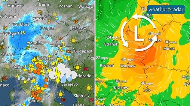
A low-pressure system is bringing heavy rain and thunderstorms from the Alps to Eastern Europe. Initially, the regions from northern Italy through Austria and Slovenia to south-eastern Germany are at risk.

There are currently thunderstorms active hereLightningRadar

By Saturday, the powerful low-pressure system will move across Poland towards the Baltic states, bringing the rain with it. Rainfall will often total between 20 and 50 mm. Locally, up to 100 mm may fall, particularly where thunderstorms break.

With such heavy rainfall, there is a risk of flooded roads, flooded basements, and landslides in the mountains. In addition, the wind is set to pick up considerably. Gusts of storm force are expected around the Alps and, later, in Poland and the Baltic states. Gusts of up to 80 miles per hour are possible.

Low brings gusting windsWindRadar
Weather & Radar editorial team
More on the topic
Lightning strikes in dry conditions. Positive earth flashes. . . Monday 17 August 2026
On the left, massive thunderclouds are gathering at night, with several flashes of lightning streaking from them. On the right, a map shows the Ligurian coast near Genoa and Savona. Numerous coloured dots over the Ligurian Sea and along the coast indicate lightning activity.
Monday 17 August 2026

Positive earth flashes

Lightning strikes in dry conditions
Severe weather risk in holiday spots. Hail and heavy rain. . . Wednesday 19 August 2026
Split weather graphic showing intense thunderstorms and widespread lightning across northern Italy and Switzerland on the left, with severe warning zones from yellow to red around Milan and the southern Alps on the right.
Wednesday 19 August 2026

Hail and heavy rain

Severe weather risk in holiday spots
An eventful week on camera. Your weather - Your shots. . . Sunday 16 August 2026
Split image showing a golden sunset reflecting across calm sea on the left and a rugged mountain rising above green vegetation and water beneath broken clouds on the right.
Sunday 16 August 2026

Your weather - Your shots

An eventful week on camera
All weather news
This might also interest you
Storm Chandra makes impact. Severe gales & heavy rain. . . Tuesday 27 January 2026
Split image showing strong winds over the UK on a forecast map and widespread rain and snow on a weather radar map.
Tuesday 27 January 2026

Severe gales & heavy rain

Storm Chandra makes impact
Bright and warm conditions take hold. Spring-like outlook. . . Thursday 23 April 2026
Split UK map showing warm temperatures up to 21 degrees in orange on the left and clear sunny conditions with temperatures from 12 to 18 degrees on the right, with sun icons across the country.
Thursday 23 April 2026

Spring-like outlook

Bright and warm conditions take hold
Turbulent weather in the Canary Islands. Storm and rain. . . Friday 12 December 2025
Weather graphic showing rain and wind fields over the Canary Islands and a central warning symbol.
Friday 12 December 2025

Storm and rain

Turbulent weather in the Canary Islands
All articles
Weather & Radar

Weather & Radar is also available on

Google Play StoreApp Store

Company

Contact us Privacy Policy Legal info Accessibility statement

Services

Uploader

Socials

facebooktwitteryouTubelinkList