Home
Weather Dublin
WeatherRadar
RainfallRadar
TemperatureRadar
WindRadar
LightningRadar
Weather News
Editor's Pick
Discover the app
Weather widget
Contact us
Apps
    Home / Editor's Pick /

    Storm Goretti hits Europe – hurricane-force winds, power outages and damage

09:09
9 January 2026

Power failures and damage
Storm Goretti hits Europe

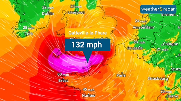
WindRadar: Goretti reached hurricane strength in the English Channel.

Storm Goretti has wreaked havoc across parts of Europe. After passing southern England, north-western France was particularly hard hit on Thursday.

Wind gusts of up to 132 miles per hour were recorded on the English Channel coast at a lighthouse in Gatteville-le-Phare, France.

Hundreds of thousands of households were without electricity, and transport and infrastructure were severely disrupted across the region. In England, Goretti brought hurricane-force winds of up to 99 mph, causing power outages and significant disruptions to rail and air traffic.

Almost 150,000 properties were reported to be without power overnight, around 62,000 still experiencing cuts, with roads also rendered impassable by fallen trees from Longrock to St Erth in Cornwall.

Snow, freezing rain and slippery roads caused traffic problems in the Benelux countries. In Germany, this was the case on Thursday night and Friday morning. In Bavaria alone, there were dozens of accidents, mostly involving minor damage to vehicles and minor injuries.

The situation will worsen during the day, particularly in northern Germany, as snowfall will continue for longer. This will be accompanied by a strong easterly wind, which will cause widespread snow drifts.

As a precautionary measure, schools in many cities and municipalities have been closed. There are also disruptions to rail services, and some buses are not running. A storm surge is threatening the Baltic Sea coast. On Saturday, widespread snowfall is expected in Central Europe.

Saturday: Getting colder from the northTemperatureRadar Europe

Tommy Kühnlein
Ryan Hathaway
More on the topic
The map shows current water temperatures in Europe and the Mediterranean. The water is particularly warm off the coast of Spain and North Africa, and cooler in the North Sea and the Baltic Sea.
Wednesday 20 May 2026

Ideal for half-term

Warming waters in holiday spots
Temperature map of the UK and western Europe showing intense red and orange heat across southern Britain, with temperatures reaching 31°C near London and a large thermometer icon beside the map.
Friday 22 May 2026

Highs over 30 degrees

Unusually warm for the long weekend
Temperature map of the UK and western Europe showing warm orange conditions with temperatures above 20°C, alongside thermometer and UV icons indicating strong sunshine and elevated UV levels.
Wednesday 20 May 2026

Sunday peak

UV levels soar over Bank Holiday weekend
All weather news
This might also interest you
Split image showing strong winds over the UK on a forecast map and widespread rain and snow on a weather radar map.
Tuesday 27 January 2026

Severe gales & heavy rain

Storm Chandra makes impact
Split UK map showing warm temperatures up to 21 degrees in orange on the left and clear sunny conditions with temperatures from 12 to 18 degrees on the right, with sun icons across the country.
Thursday 23 April 2026

Spring-like outlook

Bright and warm conditions take hold
Weather graphic showing rain and wind fields over the Canary Islands and a central warning symbol.
Friday 12 December 2025

Storm and rain

Turbulent weather in the Canary Islands
All articles
Weather & Radar

Weather & Radar is also available on

Google Play StoreApp Store

Company

Contact us Privacy Policy Legal info Accessibility statement

Services

Uploader

Socials

facebooktwitteryouTubelinkList