Home
Weather Dublin
WeatherRadar
RainfallRadar
TemperatureRadar
WindRadar
LightningRadar
Weather News
Editor's Pick
Discover the app
Weather widget
Contact us
Apps
    Home / Editor's Pick /

    More than 150 mm – Heavy rainfall in southern Europe

09:00
12 February 2026

More than 150 mm
Heavy rainfall in southern Europe

WeatherRadar: Heavy rain is expected in south-eastern Europe until the weekend.

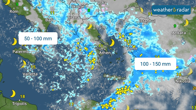
The weather in southern Europe remains turbulent, with heavy rainfall in some regions. Heavy showers and thunderstorms will sweep across southern Italy, Greece and Turkey until Friday.

Particularly on the Turkish Riviera and in the south-west of the country, 100 to 150 mm will fall. In southern Italy and on the Greek mainland, rainfall will total 50 to 100 mm.

Damage and evacuations in Portugal

Damage has already been reported in Portugal. Heavy rainfall has closed the motorway between Lisbon and Porto. A dam burst near the city of Coimbra, causing floodwaters to damage a motorway bridge.

New heavy rainfall is already on the horizon and another dam is at risk of being flooded. The authorities in Coimbra have ordered around 3,000 people to be evacuated to safety.

Dennis Oswald

More on the topic

Autumn is the season for fog. High pressure, but no sun. . . Thursday 5 November 2026
A split-screen image showing the weather radar for Europe and a mountain landscape. On the right, snow-capped peaks rise above a thick blanket of fog against a blue sky.
Thursday 5 November 2026

High pressure, but no sun

Autumn is the season for fog
Foggy mornings and crisp autumn days. Your weather - Your shots. . . Sunday 8 November 2026
Sunday 8 November 2026

Your weather - Your shots

Foggy mornings and crisp autumn days
Gloomy evening with a few spots of rain. Bonfire Night. . . Thursday 5 November 2026
Split image showing a cloudy UK weather map with temperatures of 8–9°C alongside colourful fireworks bursting through smoke in the night sky.
Thursday 5 November 2026

Bonfire Night

Gloomy evening with a few spots of rain
All weather news

This might also interest you

Storm Chandra makes impact. Severe gales & heavy rain. . . Tuesday 27 January 2026
Split image showing strong winds over the UK on a forecast map and widespread rain and snow on a weather radar map.
Tuesday 27 January 2026

Severe gales & heavy rain

Storm Chandra makes impact
Super Typhoon Bavi threatens Taiwan. Up to 1,000 mm of rain. . Weather Videos. Wednesday 8 July 2026
The image shows an intense tropical cyclone over the western Pacific, east of Taiwan and the Philippines. The centre of the system is depicted as a light purple and white vortex with a clearly visible eye, surrounded by a ring of red and orange areas indicating the strongest wind speeds. A white arrow marks the typhoon’s predicted track towards the north-west, in the direction of Taiwan. To the west of the storm lie the Philippines, with the cities of Manila and Cebu; to the north of these lies Taiwan, with Taipei. Further west, the Chinese coast, including Hong Kong, and parts of Vietnam can be seen. The coloured wind map shows predominantly green areas outside the storm’s core, indicating significantly weaker winds. White streamlines illustrate the typhoon’s anti-clockwise circulation in the Northern Hemisphere. The highest wind speeds are concentrated around the eye of the cyclone.
Weather VideosWednesday 8 July 2026

Up to 1,000 mm of rain

Super Typhoon Bavi threatens Taiwan
Seasonal warmth between spring thunder. Your weather - Your shots. . . Sunday 19 April 2026
Split image showing coastal sunset with layered lenticular clouds over rooftops and palm trees on the left, and a green valley with river and hills under soft daylight on the right.
Sunday 19 April 2026

Your weather - Your shots

Seasonal warmth between spring thunder
All articles
Weather & Radar

Weather & Radar is also available on

Google Play StoreApp Store

Company

Contact us Privacy Policy Legal info Accessibility statement

Services

Uploader

Socials

facebooktwitteryouTubelinkList