Home
Weather Dublin
WeatherRadar
RainfallRadar
TemperatureRadar
WindRadar
LightningRadar
Weather News
Editor's Pick
Discover the app
Weather widget
Contact us
Apps
    Home / Editor's Pick /

    Mediterranean bathtub - Warm waters raise severe weather risk

11:13
4 September 2026

Mediterranean bathtub
Warm waters raise severe weather risk

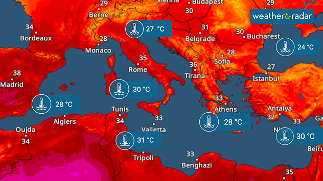
The hot summer has left its mark: the Mediterranean and the Black Sea are both unusually warm.

Particularly around Italy and south of France, the water temperature is 4 to 5 degrees above the long-term average (1991–2020). Only in the far west and east of the Mediterranean are the anomalies significantly smaller.

Extreme heat continues in SpainTemperatureRadar

As autumn approaches, the warm water could become a problem. If low-pressure systems carrying colder air move across the region, severe thunderstorms and heavy rain may develop leading to inevitable flooding.

Between southern Italy and Tunisia, temperatures are reaching 30 to 31°C – almost bathwater temperatures.

Low-pressure systems can absorb a particularly large amount of moisture above very warm water. At the same time, the significant temperature difference between the water and the air provides additional energy, and further fuels severe weather.

Weather & Radar editorial team
More on the topic
A generally gusty Thursday. Moderate but notable wind. . . Wednesday 2 September 2026
Wind forecast showing widespread 25-30 mph winds across the UK and Ireland, including Glasgow, Dublin, Cork, Cardiff, and London, with a windsock symbol.
Wednesday 2 September 2026

Moderate but notable wind

A generally gusty Thursday
Violent thunderstorms mark summer's end. Hail and gusts of wind. . Weather Videos. Thursday 27 August 2026
Severe thunderstorm warning map showing a level 3 red zone from eastern France toward Belgium, surrounded by orange and yellow alerts extending into western Germany.
Weather VideosThursday 27 August 2026

Hail and gusts of wind

Violent thunderstorms mark summer's end
Slow moving rain brings flooding. More alerts live. . . Thursday 27 August 2026
Weather radar at 11:00 on 27.08 showing widespread heavy rain from Liverpool through the Midlands to eastern England, with an arrow indicating rain moving north.
Thursday 27 August 2026

More alerts live

Slow moving rain brings flooding
All weather news
This might also interest you
Storm Chandra makes impact. Severe gales & heavy rain. . . Tuesday 27 January 2026
Split image showing strong winds over the UK on a forecast map and widespread rain and snow on a weather radar map.
Tuesday 27 January 2026

Severe gales & heavy rain

Storm Chandra makes impact
Bright and warm conditions take hold. Spring-like outlook. . . Thursday 23 April 2026
Split UK map showing warm temperatures up to 21 degrees in orange on the left and clear sunny conditions with temperatures from 12 to 18 degrees on the right, with sun icons across the country.
Thursday 23 April 2026

Spring-like outlook

Bright and warm conditions take hold
A stormy week in the skies above. Your weather - Your shots. . . Sunday 30 August 2026
Split image showing lightning branching beneath dark storm clouds above rooftops on the left and an orange-pink sunset over a calm sea on the right.
Sunday 30 August 2026

Your weather - Your shots

A stormy week in the skies above
All articles
Weather & Radar

Weather & Radar is also available on

Google Play StoreApp Store

Company

Contact us Privacy Policy Legal info Accessibility statement

Services

Uploader

Socials

facebooktwitteryouTubelinkList