Home
Weather Dublin
WeatherRadar
RainfallRadar
TemperatureRadar
WindRadar
LightningRadar
Weather News
Editor's Pick
Discover the app
Weather widget
Contact us
Apps
    Home / Editor's Pick /

    Light winds and fireworks - Conditions combine to reduce air quality

12:00
10 November 2026

Light winds and fireworks
Conditions combine to reduce air quality

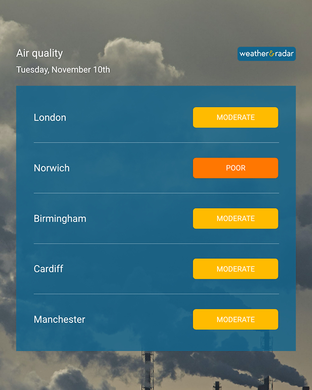
Air quality chart for Tuesday 10 November showing poor air quality in Norwich and moderate levels in London, Birmingham, Cardiff, and Manchester.
Air quality has taken a dip after fireworks and weather ripe to capture pollutants.

Days of celebrations and the current weather setup have combined to reduce air quality across the UK, with London seeing a high air pollution alert issued.

Those in the capital have been asked to reduce driving where possible and to take advantage of public transport in an effort to curb the current situation.

The cause is multifold. After the fireworks of Bonfire Night and Diwali, much of the UK has seen only light winds under high pressure. Trapping particles in the air in the aftermath of the celebrations.

These conditions also contributed to the dense fog seen in recent mornings, while fog itself also worsens air quality by further trapping pollutants.

By Thursday, windier conditions are forecast across much of the UK. This will help to move the particles left in the air away, though also brings a wintry bite to the temperatures.

Ground frost will spread in many areas with overnight temperatures falling below the seasonal average for this time of the year.

A frozen start to FridayTemperatureRadar

Ryan Hathaway

More on the topic

Europe caught between winter and summer. Frost and warmth. . . Friday 6 November 2026
Temperature Radar showing freezing temperatures in northern and eastern Europe and temperatures above 20 degrees in Spain.
Friday 6 November 2026

Frost and warmth

Europe caught between winter and summer
Further fog disruption expected. Growing dense overnight. . . Monday 9 November 2026
Weather map showing widespread fog across the English Midlands, with a red fog warning symbol near Nottingham and temperatures of 4–6°C.
Monday 9 November 2026

Growing dense overnight

Further fog disruption expected
Europe set for a change in the weather. Turning more unsettled. . . Monday 9 November 2026
European weather map showing low pressure over Scandinavia, pink snow bands across Norway and Sweden, blue rain areas and arrows indicating airflow.
Monday 9 November 2026

Turning more unsettled

Europe set for a change in the weather
All weather news

This might also interest you

Historic Storm Éowyn arrives. On this day.... . . Saturday 24 January 2026
Split image showing a person in a yellow jacket struggling against strong winds and heavy rain on a street at night on the left, and an Irish wind forecast map on the right with red and purple shading, gusts up to 75 mph, and a wind warning icon, divided by a curved white line.
Saturday 24 January 2026

On this day...

Historic Storm Éowyn arrives
Bright and warm conditions take hold. Spring-like outlook. . . Thursday 23 April 2026
Split UK map showing warm temperatures up to 21 degrees in orange on the left and clear sunny conditions with temperatures from 12 to 18 degrees on the right, with sun icons across the country.
Thursday 23 April 2026

Spring-like outlook

Bright and warm conditions take hold
A frozen start to the weekend. Icy conditions. . . Friday 13 February 2026
UK temperature map dated 14.02 showing widespread subzero values in blue shading, with readings such as −4 in Glasgow, −3 in Dublin, and −2 in London, alongside a blue thermometer icon.
Friday 13 February 2026

Icy conditions

A frozen start to the weekend
All articles
Weather & Radar

Weather & Radar is also available on

Google Play StoreApp Store

Company

Contact us Privacy Policy Legal info Accessibility statement

Services

Uploader

Socials

facebooktwitteryouTubelinkList