Home
Weather Dublin
WeatherRadar
RainfallRadar
TemperatureRadar
WindRadar
LightningRadar
Weather News
Editor's Pick
Discover the app
Weather widget
Contact us
Apps
    Home / Editor's Pick /

    Lapland ice chamber – Temperatures drop below -40 °C

10:37
13 January 2026

Lapland ice chamber
Temperatures drop below -40 °C

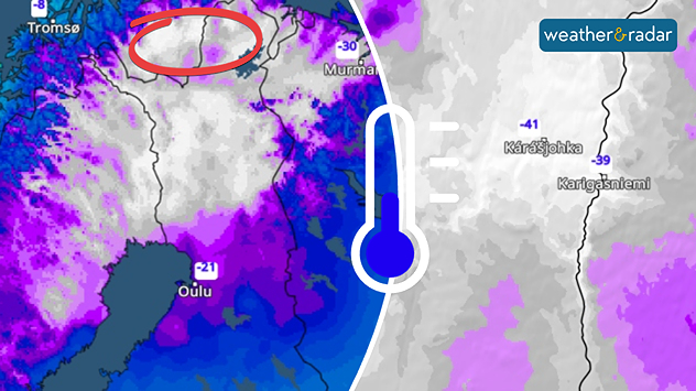
Extreme temperatures of below minus 40 degrees were recorded in Lapland over the weekend.

With lows of below -15 °C in some places, parts of Central Europe experienced the coldest nights of this winter over the weekend. It was even colder in Lapland, with lows below -40 °C recorded.

Scandinavia's lowest temperaturesread also

The coldest temperatures were recorded on Sunday in Karasjok in Finnmark, northern Norway, where the mercury dropped to minus 41.5 degrees early on Sunday morning.

Thousands of travellers were stranded in nearby Kittilä after the airport had to be completely closed due to the persistent cold.

However, the icy cold is now also receding in Lapland: it will become increasingly milder in the coming days, and only light to moderate frost is expected at the weekend – at least temporarily.

Karasjok

Tu
14
16
We
8
16
Th
10
22
Fr
10
16
Sa
6
14
Su
3
12
Mo
4
12
Tu
4
14
We
8
17
Th
9
20
Fr
10
19
Sa
8
17
Su
8
18
Mo
10
15
Max (°C)
Min (°C)
moreless
Jürgen Vollmer
More on the topic
Seeking the cooler scenes. Your weather - Your shots. . . Sunday 12 July 2026
Split image showing a cat silhouetted on a fence at golden hour with the low sun behind it on the left, and a calm marina with boats, reflective water, and thin high clouds under bright sunshine on the right.
Sunday 12 July 2026

Your weather - Your shots

Seeking the cooler scenes
Lee waves flow over the UK and Ireland. On the WeatherRadar. . . Monday 6 July 2026
Satellite weather map of the UK and Ireland showing parallel bands of low cloud highlighted over southern Scotland and northern England, with additional cloud streets over Wales and western England circled in white.
Monday 6 July 2026

On the WeatherRadar

Lee waves flow over the UK and Ireland
Cooler nights and lower dew points. Less oppressive heatwave. . . Thursday 9 July 2026
Split image showing the London skyline in hazy golden sunset light in the left and an overnight temperature map of the UK and Ireland on the right, with minimum temperatures ranging from 13°C in northeast Scotland to 18°C in southern England.
Thursday 9 July 2026

Less oppressive heatwave

Cooler nights and lower dew points
All weather news
This might also interest you
New records for England and Wales. Broken again tomorrow?. . . Thursday 25 June 2026
Temperature map of southwest Britain on 25.06 showing extreme heat across southern Wales and southwest England, with Bute Park in Cardiff highlighted at 34.2°C and Yeovilton at 36.4°C amid widespread deep red heat zones.
Thursday 25 June 2026

Broken again tomorrow?

New records for England and Wales
Historic Storm Éowyn arrives. On this day.... . . Saturday 24 January 2026
Split image showing a person in a yellow jacket struggling against strong winds and heavy rain on a street at night on the left, and an Irish wind forecast map on the right with red and purple shading, gusts up to 75 mph, and a wind warning icon, divided by a curved white line.
Saturday 24 January 2026

On this day...

Historic Storm Éowyn arrives
Super Typhoon Bavi threatens Taiwan. Up to 1,000 mm of rain. . Weather Videos. Wednesday 8 July 2026
The image shows an intense tropical cyclone over the western Pacific, east of Taiwan and the Philippines. The centre of the system is depicted as a light purple and white vortex with a clearly visible eye, surrounded by a ring of red and orange areas indicating the strongest wind speeds. A white arrow marks the typhoon’s predicted track towards the north-west, in the direction of Taiwan. To the west of the storm lie the Philippines, with the cities of Manila and Cebu; to the north of these lies Taiwan, with Taipei. Further west, the Chinese coast, including Hong Kong, and parts of Vietnam can be seen. The coloured wind map shows predominantly green areas outside the storm’s core, indicating significantly weaker winds. White streamlines illustrate the typhoon’s anti-clockwise circulation in the Northern Hemisphere. The highest wind speeds are concentrated around the eye of the cyclone.
Weather VideosWednesday 8 July 2026

Up to 1,000 mm of rain

Super Typhoon Bavi threatens Taiwan
All articles
Weather & Radar

Weather & Radar is also available on

Google Play StoreApp Store

Company

Contact us Privacy Policy Legal info Accessibility statement

Services

Uploader

Socials

facebooktwitteryouTubelinkList