Home
Weather Dublin
WeatherRadar
RainfallRadar
TemperatureRadar
WindRadar
LightningRadar
Weather News
Editor's Pick
Discover the app
Weather widget
Contact us
Apps
    Home / Editor's Pick /

    Ireland & Scotland - Heavier rainfall over the week for some

16:00
28 July 2026

Ireland & Scotland
Heavier rainfall over the week for some

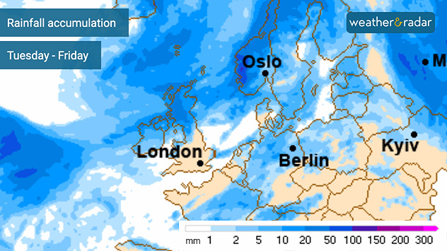
Rainfall accumulation forecast map for Europe from Tuesday to Friday showing the highest totals across the British Isles, Scandinavia, and parts of the North Atlantic in darker blue shades, with lower totals across much of central and southeastern Europe in lighter colours.
Total accumulated rain this week sees Scotland heavily coated by Friday evening.

The next heatwave grips the south-east of the UK, but across Ireland and much of Scotland the week will bring heavier bouts of rainfall.

Across western Scotland, up to 60 mm of rain could fall by the end of the week. With the total spread over three days this is unlikely to cause any significant disruption.

Total rainfall accumulation across Ireland is lower, with Northern Ireland and the north-west of Ireland seeing the most over the coming days.

Further south, the dry spell continues with just coastal East Anglia likely to see any significant rain. Even this is much lower than that seen to the north and west.

A front pushing through the area is responsible for the renewed rainfall and for keeping temperatures cooler with Ireland and Scotland sitting under low pressure. Much of England and Europe remain in the grip of high pressure keeping conditions settled and warm.

Portree

Sa
12
16
Su
10
16
Mo
13
15
Tu
12
15
We
12
13
Th
12
15
Fr
12
15
Sa
12
14
Su
10
14
Mo
10
15
Tu
11
15
We
12
16
Th
12
15
Fr
10
15
Max (°C)
Min (°C)
moreless

Galway

Sa
14
19
Su
15
18
Mo
15
19
Tu
13
17
We
13
17
Th
13
17
Fr
13
18
Sa
12
16
Su
11
17
Mo
11
18
Tu
8
18
We
11
19
Th
11
19
Fr
11
20
Max (°C)
Min (°C)
moreless

Belfast

Sa
13
20
Su
14
19
Mo
14
20
Tu
12
17
We
12
17
Th
12
16
Fr
13
17
Sa
12
16
Su
10
16
Mo
12
17
Tu
9
17
We
12
18
Th
13
18
Fr
12
18
Max (°C)
Min (°C)
moreless

Thurso

Sa
10
17
Su
7
16
Mo
12
15
Tu
10
15
We
9
14
Th
11
16
Fr
10
15
Sa
10
14
Su
7
14
Mo
7
13
Tu
7
14
We
8
16
Th
9
16
Fr
8
16
Max (°C)
Min (°C)
moreless

Glasgow

Sa
11
19
Su
11
18
Mo
15
19
Tu
13
17
We
12
15
Th
12
17
Fr
11
17
Sa
12
16
Su
8
15
Mo
9
17
Tu
9
16
We
10
17
Th
11
18
Fr
10
18
Max (°C)
Min (°C)
moreless
Ryan Hathaway
More on the topic
Severe weather hits Mallorca and Italy. Severe thunderstorms. . Weather Videos. Thursday 10 September 2026
Numerous thunderstorms are sweeping across La Palma. The many lightning symbols on the radar and lightning map show that there is heavy lightning activity across large parts of the island. The thunderstorms are striking particularly in the island’s interior and in the south. On the right, you can see the aftermath: a large fallen tree has buried a car beneath it. Emergency services are clearing up the damage. So, along with the thunderstorms, not only heavy rain but also gusts of wind can become a problem.
Weather VideosThursday 10 September 2026

Severe thunderstorms

Severe weather hits Mallorca and Italy
Autumn arrives with vivid colour. Your weather - Your shots. . . Sunday 6 September 2026
Split image showing peach-lit textured clouds above silhouetted trees and golden cumulus clouds reflected in a calm canal lined with boats.
Sunday 6 September 2026

Your weather - Your shots

Autumn arrives with vivid colour
Warm waters raise severe weather risk. Mediterranean bathtub. . Weather Videos. Friday 4 September 2026
Left: Map showing water temperatures in the Mediterranean; Right: Dark clouds over a stretch of Mediterranean coastline. A bolt of lightning strikes and a curtain of rain can be seen.
Weather VideosFriday 4 September 2026

Mediterranean bathtub

Warm waters raise severe weather risk
All weather news
This might also interest you
Super Typhoon Bavi threatens Taiwan. Up to 1,000 mm of rain. . Weather Videos. Wednesday 8 July 2026
The image shows an intense tropical cyclone over the western Pacific, east of Taiwan and the Philippines. The centre of the system is depicted as a light purple and white vortex with a clearly visible eye, surrounded by a ring of red and orange areas indicating the strongest wind speeds. A white arrow marks the typhoon’s predicted track towards the north-west, in the direction of Taiwan. To the west of the storm lie the Philippines, with the cities of Manila and Cebu; to the north of these lies Taiwan, with Taipei. Further west, the Chinese coast, including Hong Kong, and parts of Vietnam can be seen. The coloured wind map shows predominantly green areas outside the storm’s core, indicating significantly weaker winds. White streamlines illustrate the typhoon’s anti-clockwise circulation in the Northern Hemisphere. The highest wind speeds are concentrated around the eye of the cyclone.
Weather VideosWednesday 8 July 2026

Up to 1,000 mm of rain

Super Typhoon Bavi threatens Taiwan
Flooding, gales, and heavy snow. Storm Chandra. . . Tuesday 27 January 2026
Split image showing aerial flooding in a town with muddy water covering roads on the left, and a rural road on the right blocked by heavy snowfall with vans stopped and a person walking in snow.
Tuesday 27 January 2026

Storm Chandra

Flooding, gales, and heavy snow
A frozen start to the weekend. Icy conditions. . . Friday 13 February 2026
UK temperature map dated 14.02 showing widespread subzero values in blue shading, with readings such as −4 in Glasgow, −3 in Dublin, and −2 in London, alongside a blue thermometer icon.
Friday 13 February 2026

Icy conditions

A frozen start to the weekend
All articles
Weather & Radar

Weather & Radar is also available on

Google Play StoreApp Store

Company

Contact us Privacy Policy Legal info Accessibility statement

Services

Uploader

Socials

facebooktwitteryouTubelinkList